
| Memorials | : | 1 |
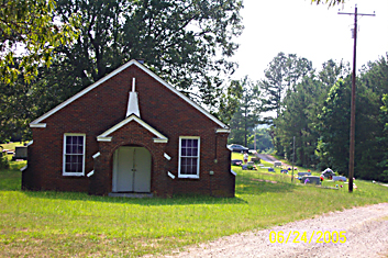
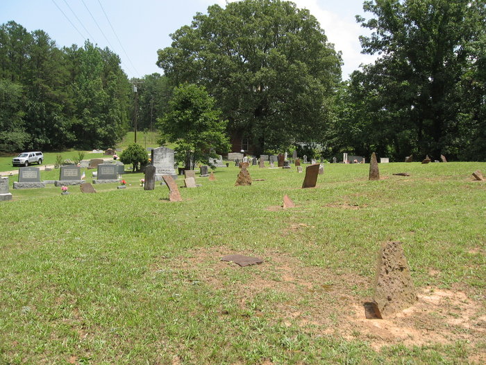
| Location | : | Forty Forks, McNairy County, USA |
| Coordinate | : | 35.2673800, -88.5787980 |
| Description | : | From the intersection of Limon Gage Rd. & Otis Plunk Rd., north of Bethel Springs, travel east on Limon Gage Rd. for 1.5 mi.; turning north (left) into a driveway to the Rose Hill Church & to the cemetery north of the church. |
frequently asked questions (FAQ):
-
Where is Rose Hill Cemetery?
Rose Hill Cemetery is located at 1470Limon Gage Road Forty Forks, McNairy County ,Tennessee ,USA.
-
Rose Hill Cemetery cemetery's updated grave count on graveviews.com?
0 memorials
-
Where are the coordinates of the Rose Hill Cemetery?
Latitude: 35.2673800
Longitude: -88.5787980
Nearby Cemetories:
1. Liberty Church Cemetery
Forty Forks, McNairy County, USA
Coordinate: 35.2770890, -88.5806060
2. Beaty Cemetery
Forty Forks, McNairy County, USA
Coordinate: 35.2901030, -88.5676270
3. Beauty Hill Church Cemetery
Purdy, McNairy County, USA
Coordinate: 35.2621840, -88.5426830
4. Chapel Hill Cemetery
Bethel Springs, McNairy County, USA
Coordinate: 35.2373190, -88.5663610
5. Dunn Cemetery
Bethel Springs, McNairy County, USA
Coordinate: 35.2666290, -88.5355270
6. Bethel Springs Cemetery
Bethel Springs, McNairy County, USA
Coordinate: 35.2332380, -88.6066780
7. Motley Family Cemetery
Bethel Springs, McNairy County, USA
Coordinate: 35.2294220, -88.6108090
8. Purdy Wright Cemetery
Purdy, McNairy County, USA
Coordinate: 35.2306570, -88.5403730
9. Chambers Chapel Cemetery
McNairy, McNairy County, USA
Coordinate: 35.3044180, -88.6185380
10. Purdy Wisdom Cemetery
Purdy, McNairy County, USA
Coordinate: 35.2343230, -88.5341050
11. New Salem Church Cemetery
Bethel Springs, McNairy County, USA
Coordinate: 35.2608980, -88.6389090
12. Wharton Cemetery
Purdy, McNairy County, USA
Coordinate: 35.2898140, -88.5192220
13. Lake Hill Memory Gardens
Bethel Springs, McNairy County, USA
Coordinate: 35.2169810, -88.6048380
14. Mount Zion Baptist Church Cemetery
McNairy, McNairy County, USA
Coordinate: 35.3139000, -88.6235962
15. Hendrix Cemetery
Finger, McNairy County, USA
Coordinate: 35.3189590, -88.5338280
16. Lanes Chapel Cemetery
Finger, McNairy County, USA
Coordinate: 35.3312510, -88.5639110
17. Alexander Cemetery
Finger, McNairy County, USA
Coordinate: 35.3029830, -88.5120090
18. Buena Vista Church Cemetery
Bethel Springs, McNairy County, USA
Coordinate: 35.2394910, -88.6520210
19. Bethesda Memorial Gardens
Selmer, McNairy County, USA
Coordinate: 35.1988880, -88.5709240
20. Brooks Cemetery
Purdy, McNairy County, USA
Coordinate: 35.2082660, -88.5330580
21. Refuge Church Cemetery
Finger, McNairy County, USA
Coordinate: 35.2888985, -88.6616974
22. Good Hope Cemetery
Adamsville, McNairy County, USA
Coordinate: 35.2552986, -88.4888992
23. Gateway Holiness Chapel Cemetery
Bethel Springs, McNairy County, USA
Coordinate: 35.2757390, -88.6718300
24. Mount Carmel Cemetery
Finger, McNairy County, USA
Coordinate: 35.3424988, -88.6003036