
| Memorials | : | 3 |
| Location | : | Kenilworth, Wellington County, Canada |
| Coordinate | : | 43.9067993, -80.6410217 |
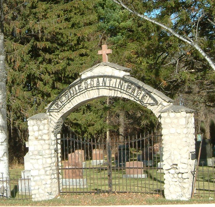
| Description | : | "In 1903, Father Daniel Kehoe had a church built on the existing grounds in Kenilworth, known as Sacred Heart Church. Rev. Kehoe then purchased 6 acres of land north of the church property from Fred O’Donnell and one acre was then surveyed for a cemetery. The first burial in Sacred Heart Cemetery was 24 Aug. 1908 of Mary Ann O'Laughlin, aged 45 years, wife of John Purtell. The stone fence and gateway were erected in 1935. The cemetery records were looked after by the Parish Priest until July of 1944 when a cemetery board was appointed. Since that time more... Read More |
frequently asked questions (FAQ):
-
Where is Sacred Heart Roman Catholic Cemetery?
Sacred Heart Roman Catholic Cemetery is located at 9147 Hwy 6 Kenilworth, Wellington County ,Ontario ,Canada.
-
Sacred Heart Roman Catholic Cemetery cemetery's updated grave count on graveviews.com?
3 memorials
-
Where are the coordinates of the Sacred Heart Roman Catholic Cemetery?
Latitude: 43.9067993
Longitude: -80.6410217
Nearby Cemetories:
1. Kenilworth Pioneer Catholic Cemetery
Kenilworth, Wellington County, Canada
Coordinate: 43.9085900, -80.6464300
2. Kenilworth Methodist Cemetery
Kenilworth, Wellington County, Canada
Coordinate: 43.8926964, -80.6166458
3. Petherton Pioneer Baptist Cemetery
Petherton, Wellington County, Canada
Coordinate: 43.8842850, -80.6084900
4. Farewell Mennonite Cemetery
Farewell, Wellington County, Canada
Coordinate: 43.9053140, -80.7182690
5. Bethel Pioneer Cemetery
Wellington County, Canada
Coordinate: 43.9274480, -80.7271960
6. Riverdale Mennonite Cemetery
Landerkin, Grey County, Canada
Coordinate: 43.9980545, -80.6197205
7. Derryadd Cemetery
Rothsay, Wellington County, Canada
Coordinate: 43.8168200, -80.6848900
8. Greenfield Cemetery
Arthur, Wellington County, Canada
Coordinate: 43.8287070, -80.5598260
9. Saint John the Evangelist Roman Catholic Cemetery
Arthur, Wellington County, Canada
Coordinate: 43.8293300, -80.5559700
10. Holy Cross Roman Catholic Cemetery
Mount Forest, Wellington County, Canada
Coordinate: 43.9679450, -80.7519100
11. Zion United Church Cemetery
Drayton, Wellington County, Canada
Coordinate: 43.7973382, -80.6375023
12. Mount Forest Cemetery
Southgate Township, Grey County, Canada
Coordinate: 44.0039100, -80.7266500
13. Woodland Cemetery
Egremont Township, Grey County, Canada
Coordinate: 44.0238904, -80.6774183
14. Saint Thomas Roman Catholic Cemetery
Wellington County, Canada
Coordinate: 43.9511810, -80.8071900
15. Berea Mennonite Cemetery
Bosworth, Wellington County, Canada
Coordinate: 43.7793980, -80.6300350
16. Cochrane Cemetery
Mount Forest, Wellington County, Canada
Coordinate: 44.0028500, -80.7740300
17. Westdale Mennonite Cemetery
Minto, Wellington County, Canada
Coordinate: 43.9300750, -80.8287760
18. Saint Patricks Roman Catholic Cemetery
Cedarville, Grey County, Canada
Coordinate: 44.0309029, -80.5493546
19. Drayton Victoria Cemetery
Drayton, Wellington County, Canada
Coordinate: 43.7651972, -80.6629083
20. Bethesda Community Cemetery
Moorefield, Wellington County, Canada
Coordinate: 43.7817530, -80.7380320
21. Chilton Cemetery
Normanby Township, Grey County, Canada
Coordinate: 43.9811480, -80.8129810
22. Lymburner Cemetery
Kelvin, Brant County Municipality, Canada
Coordinate: 43.9968000, -80.4688000
23. Drayton Methodist Church and Cemetery
Drayton, Wellington County, Canada
Coordinate: 43.7525000, -80.6641670
24. Hiltz Methodist Cemetery
Southgate Township, Grey County, Canada
Coordinate: 44.0415434, -80.7565276