
| Memorials | : | 0 |
| Location | : | Mateer, Armstrong County, USA |
| Coordinate | : | 40.6394230, -79.4799040 |
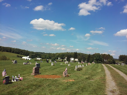
| Description | : | There is bound to be confusion with this cemetery...There is a Shellhammer Cemetery, in Mateer about one half mile as the Crow flies from this place and it is a cemetery that belongs to descendants of this family. There is also a Shellhammer Addition Cemetery about 1/4 mile from that one, consisting of only a very few graves. Then there is this one on the King Sawmill Property and it is known as the Shellhammer-Back Cemetery. All three of these are within one half mile of each other. This one is located on the Homer King Sawmill property... Read More |
frequently asked questions (FAQ):
-
Where is Shellhammer-Beck Cemetery?
Shellhammer-Beck Cemetery is located at Mateer, Armstrong County ,Pennsylvania ,USA.
-
Shellhammer-Beck Cemetery cemetery's updated grave count on graveviews.com?
0 memorials
-
Where are the coordinates of the Shellhammer-Beck Cemetery?
Latitude: 40.6394230
Longitude: -79.4799040
Nearby Cemetories:
1. Shellhammer Cemetery
Mateer, Armstrong County, USA
Coordinate: 40.6420000, -79.4887000
2. Shellhammer Cemetery
Mateer, Armstrong County, USA
Coordinate: 40.6404860, -79.4944850
3. Ramaley Family Cemetery
Cochrans Mills, Armstrong County, USA
Coordinate: 40.6574780, -79.4585220
4. Shoemaker Family Cemetery
Cochrans Mills, Armstrong County, USA
Coordinate: 40.6639400, -79.4665790
5. Dunkard Baptist Christian Bretheren Cemetery
Cochrans Mills, Armstrong County, USA
Coordinate: 40.6697655, -79.4726105
6. Cochrans Mill United Methodist Church Cemetery
Cochrans Mills, Armstrong County, USA
Coordinate: 40.6706000, -79.4700000
7. Fairview Cemetery
Spring Church, Armstrong County, USA
Coordinate: 40.6075000, -79.4899000
8. McDonald Cemetery
Burrell Township, Armstrong County, USA
Coordinate: 40.6603012, -79.4464035
9. Spring Church Joint Cemetery
Spring Church, Armstrong County, USA
Coordinate: 40.6069000, -79.4902000
10. Highfield Lutheran Church Cemetery
North Vandergrift, Armstrong County, USA
Coordinate: 40.6392441, -79.5245590
11. Spring Church Lutheran Church Cemetery
Spring Church, Armstrong County, USA
Coordinate: 40.6067009, -79.4916992
12. Porter Cemetery
Armstrong County, USA
Coordinate: 40.6618996, -79.5147018
13. Saint Michael's Lutheran Church Cemetery
Brick Church, Armstrong County, USA
Coordinate: 40.6831360, -79.4557114
14. Mount Zion United Methodist Church Cemetery
Girty, Armstrong County, USA
Coordinate: 40.6555710, -79.4134674
15. Laurel Point Cemetery
Armstrong County, USA
Coordinate: 40.6203003, -79.5543976
16. Shaeffer Cemetery
Brick Church, Armstrong County, USA
Coordinate: 40.6927986, -79.4441986
17. Rupert Cemetery
Girty, Armstrong County, USA
Coordinate: 40.6596550, -79.4020500
18. Smail Family Cemetery
North Vandergrift, Armstrong County, USA
Coordinate: 40.6781730, -79.5466050
19. Bethel Lutheran Church Cemetery
Ford City, Armstrong County, USA
Coordinate: 40.6969290, -79.5336720
20. Olivet Cemetery
South Bend, Armstrong County, USA
Coordinate: 40.5872000, -79.4106000
21. Parks Family Cemetery
Kiskimere, Armstrong County, USA
Coordinate: 40.6267950, -79.5775470
22. Rowley Cemetery
Elderton, Armstrong County, USA
Coordinate: 40.6889750, -79.4027500
23. Crooked Creek Presbyterian Cemetery
Ford City, Armstrong County, USA
Coordinate: 40.7104000, -79.5197000
24. Shotts Cemetery
Armstrong County, USA
Coordinate: 40.7186012, -79.4753036