
| Memorials | : | 0 |
| Location | : | Cochrans Mills, Armstrong County, USA |
| Coordinate | : | 40.6574780, -79.4585220 |
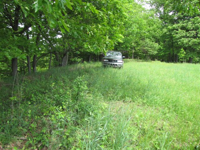
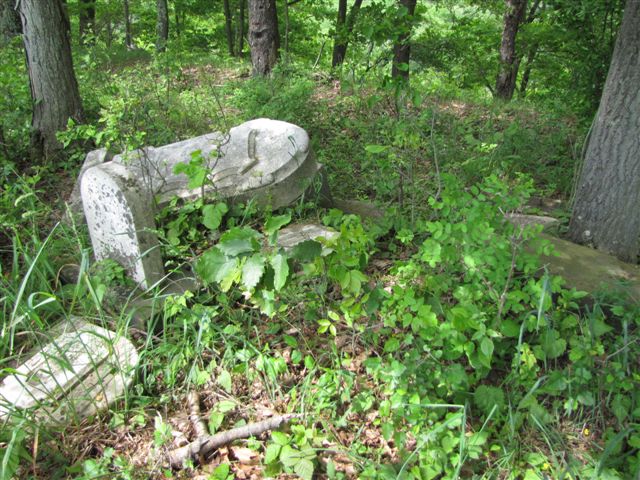
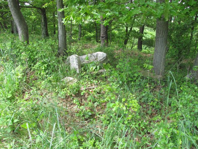
| Description | : | This is a very small family cemetery on what was once the Ramaley Family Farm. They chose a field over by the very steep hillside that drops to the Crooked Creek Valley, below. This place has been a farm field for more then 200 years. The cemetery is in great disrepair and the current owner, Mr. Fulton is crippled and aged but has made a good attempt to keep the place clear. He cannot lift the markers but it is accessable. (Although four wheel drive or foot travel is certainly encouraged.) There are two marked... Read More |
frequently asked questions (FAQ):
-
Where is Ramaley Family Cemetery?
Ramaley Family Cemetery is located at Cochrans Mills, Armstrong County ,Pennsylvania ,USA.
-
Ramaley Family Cemetery cemetery's updated grave count on graveviews.com?
0 memorials
-
Where are the coordinates of the Ramaley Family Cemetery?
Latitude: 40.6574780
Longitude: -79.4585220
Nearby Cemetories:
1. Shoemaker Family Cemetery
Cochrans Mills, Armstrong County, USA
Coordinate: 40.6639400, -79.4665790
2. McDonald Cemetery
Burrell Township, Armstrong County, USA
Coordinate: 40.6603012, -79.4464035
3. Cochrans Mill United Methodist Church Cemetery
Cochrans Mills, Armstrong County, USA
Coordinate: 40.6706000, -79.4700000
4. Dunkard Baptist Christian Bretheren Cemetery
Cochrans Mills, Armstrong County, USA
Coordinate: 40.6697655, -79.4726105
5. Shellhammer-Beck Cemetery
Mateer, Armstrong County, USA
Coordinate: 40.6394230, -79.4799040
6. Saint Michael's Lutheran Church Cemetery
Brick Church, Armstrong County, USA
Coordinate: 40.6831360, -79.4557114
7. Shellhammer Cemetery
Mateer, Armstrong County, USA
Coordinate: 40.6420000, -79.4887000
8. Shellhammer Cemetery
Mateer, Armstrong County, USA
Coordinate: 40.6404860, -79.4944850
9. Mount Zion United Methodist Church Cemetery
Girty, Armstrong County, USA
Coordinate: 40.6555710, -79.4134674
10. Shaeffer Cemetery
Brick Church, Armstrong County, USA
Coordinate: 40.6927986, -79.4441986
11. Porter Cemetery
Armstrong County, USA
Coordinate: 40.6618996, -79.5147018
12. Rupert Cemetery
Girty, Armstrong County, USA
Coordinate: 40.6596550, -79.4020500
13. Rowley Cemetery
Elderton, Armstrong County, USA
Coordinate: 40.6889750, -79.4027500
14. Highfield Lutheran Church Cemetery
North Vandergrift, Armstrong County, USA
Coordinate: 40.6392441, -79.5245590
15. Fairview Cemetery
Spring Church, Armstrong County, USA
Coordinate: 40.6075000, -79.4899000
16. Spring Church Joint Cemetery
Spring Church, Armstrong County, USA
Coordinate: 40.6069000, -79.4902000
17. Spring Church Lutheran Church Cemetery
Spring Church, Armstrong County, USA
Coordinate: 40.6067009, -79.4916992
18. Saint John's Lutheran Church Cemetery
Ford City, Armstrong County, USA
Coordinate: 40.7197037, -79.4614410
19. Shotts Cemetery
Armstrong County, USA
Coordinate: 40.7186012, -79.4753036
20. Montgomery Family Cemetery
South Bend, Armstrong County, USA
Coordinate: 40.6597000, -79.3714000
21. Mount Union Lutheran Church Cemetery
Elderton, Armstrong County, USA
Coordinate: 40.6876678, -79.3781967
22. Bethel Lutheran Church Cemetery
Ford City, Armstrong County, USA
Coordinate: 40.6969290, -79.5336720
23. Smail Family Cemetery
North Vandergrift, Armstrong County, USA
Coordinate: 40.6781730, -79.5466050
24. South Bend Cemetery
Elderton, Armstrong County, USA
Coordinate: 40.6370087, -79.3699417