
| Memorials | : | 2 |
| Location | : | Wyddial, East Hertfordshire District, England |
| Coordinate | : | 51.9673270, -0.0010730 |
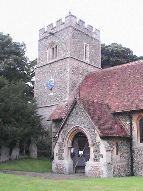
| Description | : | The church is a grade I listed building of 14th century origin. Of special interest are the north chancel and chapel, both built of brick and dated by a brass inscription 1532. The triumphant entry of brick into church buildings is a significant sign of the Tudor age. Of particular interest also are the two 16th century stained glass windows of Flemish origin showing scenes from the passion. The church itself occupies a unique position, in that it sits astride the meridian line - probably the only church in England to do so |
frequently asked questions (FAQ):
-
Where is St Giles Churchyard?
St Giles Churchyard is located at Vicarage Road Wyddial, East Hertfordshire District ,Hertfordshire , SG9 ONTEngland.
-
St Giles Churchyard cemetery's updated grave count on graveviews.com?
2 memorials
-
Where are the coordinates of the St Giles Churchyard?
Latitude: 51.9673270
Longitude: -0.0010730

Nearby Cemetories:
1. St Bartholomew's Church Churchyard
Buntingford, East Hertfordshire District, England
Coordinate: 51.9525530, -0.0089720
2. Hare Street Benson Grounds
Buntingford, East Hertfordshire District, England
Coordinate: 51.9492640, 0.0221120
3. St Andrew Churchyard
Buckland, East Hertfordshire District, England
Coordinate: 51.9866510, -0.0230880
4. St George Churchyard
Anstey, East Hertfordshire District, England
Coordinate: 51.9766990, 0.0431300
5. Great Hormead St Nicholas Churchyard
Hormead, East Hertfordshire District, England
Coordinate: 51.9469500, 0.0353300
6. Little Hormead St Mary Churchyard
Hormead, East Hertfordshire District, England
Coordinate: 51.9428430, 0.0331630
7. Holy Trinity Churchyard
Buntingford, East Hertfordshire District, England
Coordinate: 51.9540854, -0.0541753
8. St Mary Magdalene Churchyard
Barkway, North Hertfordshire District, England
Coordinate: 52.0015793, 0.0129600
9. St Mary Churchyard
Reed, North Hertfordshire District, England
Coordinate: 52.0034714, -0.0183250
10. Barkway Chapel Cemetery
Barkway, North Hertfordshire District, England
Coordinate: 52.0047910, 0.0151040
11. St. Mary the Virgin-Westmill
St Albans, St Albans District, England
Coordinate: 51.9262000, -0.0098000
12. All Saints Churchyard
Sandon, North Hertfordshire District, England
Coordinate: 51.9934160, -0.0756170
13. St John the Baptist Churchyard
Cottered, East Hertfordshire District, England
Coordinate: 51.9458000, -0.0846000
14. St Faiths Churchyard
Kelshall, North Hertfordshire District, England
Coordinate: 52.0084230, -0.0656070
15. Saint Mary Churchyard
Meesden, East Hertfordshire District, England
Coordinate: 51.9728000, 0.0934270
16. St Mary the Virgin Churchyard
Therfield, North Hertfordshire District, England
Coordinate: 52.0162060, -0.0568230
17. St Mary Churchyard
Rushden, North Hertfordshire District, England
Coordinate: 51.9689930, -0.1012800
18. St Mary the Virgin Churchyard
Furneux Pelham, East Hertfordshire District, England
Coordinate: 51.9316710, 0.0808950
19. St Mary the Virgin Churchyard
Braughing, East Hertfordshire District, England
Coordinate: 51.9078420, 0.0282310
20. St Nicholas Churchyard
Little Chishill, South Cambridgeshire District, England
Coordinate: 52.0154690, 0.0654890
21. St. Margaret of Antioch Churchyard
Barley, North Hertfordshire District, England
Coordinate: 52.0264390, 0.0416390
22. St. John The Evangelist Churchyard
Langley, Uttlesford District, England
Coordinate: 51.9969356, 0.0995640
23. St. Nicholas' Churchyard
Great Munden, East Hertfordshire District, England
Coordinate: 51.8996010, -0.0316180
24. St Lawrence Churchyard
Ardeley, East Hertfordshire District, England
Coordinate: 51.9274000, -0.0989000