
| Memorials | : | 0 |
| Location | : | Horsham, Horsham District, England |
| Coordinate | : | 50.9730110, -0.2827360 |
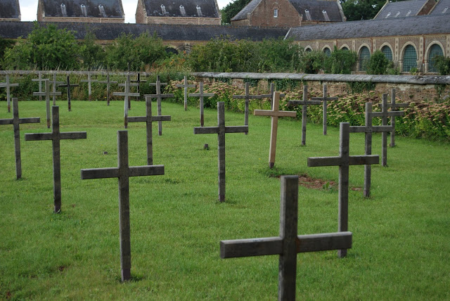
| Description | : | St. Hugh's Charterhouse, Parkminster is the only post-Reformation Carthusian monastery in the United Kingdom. It is located in the parish of Cowfold, West Sussex, England. The monastery was founded in 1873, when the property formerly known as Picknoll was acquired for its construction in order to accommodate two houses of continental Carthusians in exile. Building took place between 1876 to 1883 to designs by a French architect, Clovis Normand, who had at his disposal a generous budget. The number of monks has varied: 30 in 1883, 70 in 1928, 22 in 1984. The buildings are in a French Gothic Revival style. The... Read More |
frequently asked questions (FAQ):
-
Where is St Hugh's Charterhouse?
St Hugh's Charterhouse is located at Horsham, Horsham District ,West Sussex , RH13 8EBEngland.
-
St Hugh's Charterhouse cemetery's updated grave count on graveviews.com?
0 memorials
-
Where are the coordinates of the St Hugh's Charterhouse?
Latitude: 50.9730110
Longitude: -0.2827360

Nearby Cemetories:
1. St Peter Churchyard
Cowfold, Horsham District, England
Coordinate: 50.9898500, -0.2740200
2. St Giles Churchyard
Shermanbury, Horsham District, England
Coordinate: 50.9561320, -0.2726010
3. St Michael and All Angels Churchyard
West Grinstead, Horsham District, England
Coordinate: 50.9619680, -0.3081750
4. St Michael & All Angels Churchyard
Partridge Green, Horsham District, England
Coordinate: 50.9618600, -0.3081540
5. Our Lady Of Consolation and St Francis Churchyard
West Grinstead, Horsham District, England
Coordinate: 50.9779220, -0.3245590
6. St George Churchyard
West Grinstead, Horsham District, England
Coordinate: 50.9736360, -0.3336990
7. Henfield Cemetery
Henfield, Horsham District, England
Coordinate: 50.9342000, -0.2764400
8. St Peter's Churchyard
Henfield, Horsham District, England
Coordinate: 50.9323340, -0.2762030
9. St Peters Churchyard
Twineham, Mid Sussex District, England
Coordinate: 50.9657310, -0.2174410
10. St James Churchyard
Ashurst, Horsham District, England
Coordinate: 50.9347992, -0.3273070
11. St Andrew Churchyard
Nuthurst, Horsham District, England
Coordinate: 51.0222790, -0.3010080
12. St. Mary Magdalene Churchyard
Bolney, Mid Sussex District, England
Coordinate: 50.9898000, -0.2035200
13. St Peter's Churchyard
Woodmancote, Horsham District, England
Coordinate: 50.9213180, -0.2497350
14. St Mary the Virgin Churchyard
Shipley, Horsham District, England
Coordinate: 50.9842530, -0.3701900
15. Holy Trinity Churchyard
Lower Beeding, Horsham District, England
Coordinate: 51.0331850, -0.2610280
16. Southwater Parish Cemetery
Southwater, Horsham District, England
Coordinate: 51.0245167, -0.3574486
17. The Church of the Holy Innocents Cemetery
Southwater, Horsham District, England
Coordinate: 51.0244290, -0.3576390
18. Holy Innocents Churchyard
Southwater, Horsham District, England
Coordinate: 51.0252410, -0.3584748
19. Holy Trinity Churchyard
Hurstpierpoint, Mid Sussex District, England
Coordinate: 50.9337020, -0.1804460
20. Hurstpierpoint South Avenue Cemetery
Hurstpierpoint, Mid Sussex District, England
Coordinate: 50.9300110, -0.1753150
21. Burgess Hill Burial Ground
Burgess Hill, Mid Sussex District, England
Coordinate: 50.9542794, -0.1583567
22. St Mary Churchyard
Slaugham, Mid Sussex District, England
Coordinate: 51.0385470, -0.2081720
23. St John The Evangelist Churchyard
Lower Beeding, Horsham District, England
Coordinate: 51.0552500, -0.2889280
24. All Saints Churchyard
Wiston, Horsham District, England
Coordinate: 50.9132350, -0.3725910