
| Memorials | : | 13 |
| Location | : | Hempsted, City of Gloucester, England |
| Coordinate | : | 51.8602130, -2.2572640 |
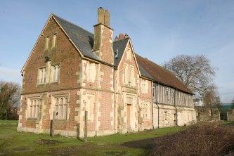
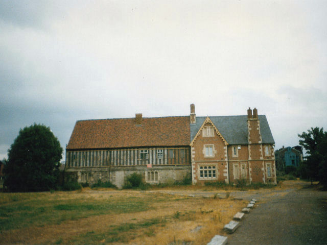
| Description | : | This is a ruined former Augustinian priory in Hempsted, Gloucester, England, founded in 1136 by Miles FitzWalter of Gloucester, the 1st Earl of Hereford, for the monks of Llanthony Priory, Vale of Ewyas. The monks of Llanthony Priory in the Black Mountains retreated from Wales to the new Llanthony Secunda Priory in Gloucester, due to attacks from the locals. During the Dissolution of the Monasteries in 1538, and the priory and lands were granted to Arthur Porter. |
frequently asked questions (FAQ):
-
Where is Llanthony Secunda Priory?
Llanthony Secunda Priory is located at Hempsted, City of Gloucester ,Gloucestershire ,England.
-
Llanthony Secunda Priory cemetery's updated grave count on graveviews.com?
13 memorials
-
Where are the coordinates of the Llanthony Secunda Priory?
Latitude: 51.8602130
Longitude: -2.2572640
Nearby Cemetories:
1. St Nicholas' Church
Gloucester, City of Gloucester, England
Coordinate: 51.8672800, -2.2496760
2. Gloucester Cathedral
Gloucester, City of Gloucester, England
Coordinate: 51.8675920, -2.2467670
3. Saint Oswald's Priory
Gloucester, City of Gloucester, England
Coordinate: 51.8694000, -2.2478000
4. St. Swithun's Churchyard
Hempsted, City of Gloucester, England
Coordinate: 51.8515740, -2.2719420
5. St Margaret's Chapel
Gloucester, City of Gloucester, England
Coordinate: 51.8686720, -2.2321530
6. Chapel of St Mary Magdalen
Gloucester, City of Gloucester, England
Coordinate: 51.8693000, -2.2291000
7. Horton Road Cemetery
Gloucester, City of Gloucester, England
Coordinate: 51.8666900, -2.2268300
8. Saint Catharine's
Gloucester, City of Gloucester, England
Coordinate: 51.8691700, -2.2273500
9. Gloucester Old Cemetery
Gloucester, City of Gloucester, England
Coordinate: 51.8482100, -2.2276700
10. Gloucester Crematorium
Gloucester, City of Gloucester, England
Coordinate: 51.8538180, -2.2219260
11. Holy Innocents Churchyard
Highnam, Tewkesbury Borough, England
Coordinate: 51.8740890, -2.2970050
12. St Lawrence Churchyard
Barnwood, City of Gloucester, England
Coordinate: 51.8580470, -2.2069750
13. St. Giles Churchyard
Maisemore, Tewkesbury Borough, England
Coordinate: 51.8931690, -2.2719540
14. St. Matthew's Cemetery
Twigworth, Tewkesbury Borough, England
Coordinate: 51.8936090, -2.2307820
15. St. James' Churchyard
Quedgeley, City of Gloucester, England
Coordinate: 51.8257770, -2.2811150
16. St. Oswald Churchyard
Lassington, Tewkesbury Borough, England
Coordinate: 51.8884700, -2.2978000
17. St Margaret Church
Whaddon, Stroud District, England
Coordinate: 51.8214600, -2.2433000
18. Ss Philip and James Churchyard
Hucclecote, Tewkesbury Borough, England
Coordinate: 51.8573040, -2.1876440
19. St. Peter's Churchyard
Minsterworth, Tewkesbury Borough, England
Coordinate: 51.8511500, -2.3307800
20. St Lawrence Churchyard
Sandhurst, Tewkesbury Borough, England
Coordinate: 51.9083260, -2.2489570
21. St. Andrew's Churchyard
Churcham, Forest of Dean District, England
Coordinate: 51.8618970, -2.3375000
22. St. Mary the Virgin Cemetery
Rudford, Forest of Dean District, England
Coordinate: 51.8936272, -2.3213976
23. St. Swithun Churchyard
Brookthorpe, Stroud District, England
Coordinate: 51.8087500, -2.2402900
24. St Nicholas Churchyard
Hardwicke, Stroud District, England
Coordinate: 51.8101200, -2.3007300