
| Memorials | : | 1 |
| Location | : | Buckden, Huntingdonshire District, England |
| Website | : | www.stmarysbuckden.org.uk |
| Coordinate | : | 52.2941000, -0.2526000 |
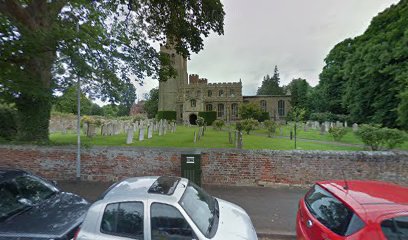
| Description | : | St Mary's church dates back to the 15th century, in it's current form, but there would have been a much earlier building dating back to the 13th century. There are some brass memorials inside the church to Bishops in the Chancel and beneath the altar in addition to one at the east end of the north aisle. According to the illustrated guide-booklet, there are 383 gravestones in the churchyard most notable of which is a medieval table top tomb said to contain the remains of the young Dukes of Suffolk. The churchyard closed in 1883 at... Read More |
frequently asked questions (FAQ):
-
Where is St Mary's Churchyard?
St Mary's Churchyard is located at Church Street Buckden, Huntingdonshire District ,Cambridgeshire , PE19 5TLEngland.
-
St Mary's Churchyard cemetery's updated grave count on graveviews.com?
1 memorials
-
Where are the coordinates of the St Mary's Churchyard?
Latitude: 52.2941000
Longitude: -0.2526000
Nearby Cemetories:
1. Lucks Lane Cemetery
Buckden, Huntingdonshire District, England
Coordinate: 52.2910048, -0.2530740
2. St. Lawrence's Churchyard
Diddington, Huntingdonshire District, England
Coordinate: 52.2784800, -0.2578000
3. All Saints Churchyard
Offord Cluny, Huntingdonshire District, England
Coordinate: 52.2878400, -0.2144120
4. St Peter's Churchyard
Offord d'Arcy, Huntingdonshire District, England
Coordinate: 52.2824000, -0.2178000
5. St Leonard Churchyard
Southoe, Huntingdonshire District, England
Coordinate: 52.2654070, -0.2679460
6. Brampton Cemetery
Brampton, Huntingdonshire District, England
Coordinate: 52.3212480, -0.2177190
7. Holy Trinity Churchyard
Great Paxton, Huntingdonshire District, England
Coordinate: 52.2620300, -0.2291600
8. Little Paxton Cemetery
Little Paxton, Huntingdonshire District, England
Coordinate: 52.2548800, -0.2764600
9. St. Mary the Virgin Churchyard
Godmanchester, Huntingdonshire District, England
Coordinate: 52.3202190, -0.1744400
10. Godmanchester War Memorial
Godmanchester, Huntingdonshire District, England
Coordinate: 52.3225780, -0.1759580
11. All Saints Parish Churchyard
Huntingdon, Huntingdonshire District, England
Coordinate: 52.3307170, -0.1849760
12. GODMANCHESTER LAWN CEMETERY
Godmanchester, Huntingdonshire District, England
Coordinate: 52.3091902, -0.1655030
13. St Nicholas Churchyard
Hail Weston, Huntingdonshire District, England
Coordinate: 52.2447100, -0.2945500
14. St Marys Churchyard
Huntingdon, Huntingdonshire District, England
Coordinate: 52.3289548, -0.1799861
15. Priory Road Cemetery
Huntingdon, Huntingdonshire District, England
Coordinate: 52.3334320, -0.1796500
16. St Botolph Churchyard
Graveley, South Cambridgeshire District, England
Coordinate: 52.2605200, -0.1701700
17. Primrose Lane Lawn Cemetery
Huntingdonshire District, England
Coordinate: 52.3334666, -0.1760611
18. St Andrew Churchyard
Great Staughton, Huntingdonshire District, England
Coordinate: 52.2691765, -0.3504967
19. New Street Baptist Church St Neots
St Neots, Huntingdonshire District, England
Coordinate: 52.2290700, -0.2686400
20. St. Neots Priory
St Neots, Huntingdonshire District, England
Coordinate: 52.2281710, -0.2705280
21. Old Cemetery
Great Staughton, Huntingdonshire District, England
Coordinate: 52.2694189, -0.3546817
22. Parish Church of St. Mary the Virgin
St Neots, Huntingdonshire District, England
Coordinate: 52.2268700, -0.2671700
23. St. Neots Cemetery
St Neots, Huntingdonshire District, England
Coordinate: 52.2253680, -0.2641010
24. St. Andrew's Church Cemetery
Great Staughton, Huntingdonshire District, England
Coordinate: 52.2677700, -0.3573400