
| Memorials | : | 3 |
| Location | : | Stratton Audley, Cherwell District, England |
| Coordinate | : | 51.9294810, -1.1164160 |
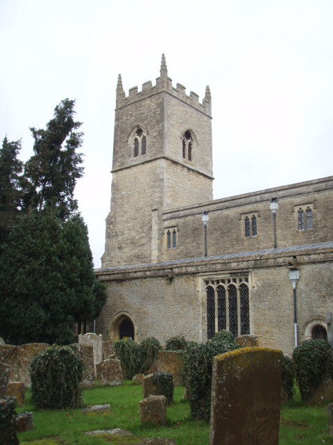
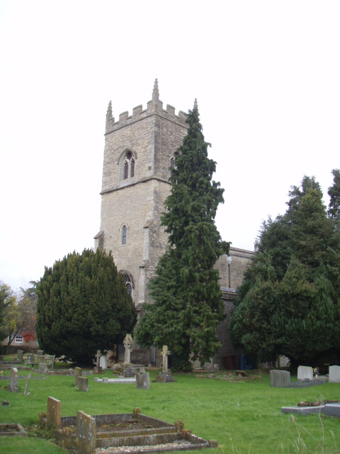
| Description | : | The Church of England parish church of Saint Mary and Saint Edburga dates from the 12th century but was largely rebuilt in the 13th and 14th centuries. The Decorated Gothic bell tower was added late in the 14th century.The tower has a peal of six bells, three of which were cast in 1693 St Mary & St Edburga's is now part of the benefice of Stratton Audley with Godington, Fringford with Hethe and Stoke Lyne. The benefice is part of the Shelswell group of parishes. Added by wertypop. |
frequently asked questions (FAQ):
-
Where is SS Mary & Edburga Churchyard?
SS Mary & Edburga Churchyard is located at Church Street Stratton Audley, Cherwell District ,Oxfordshire ,England.
-
SS Mary & Edburga Churchyard cemetery's updated grave count on graveviews.com?
3 memorials
-
Where are the coordinates of the SS Mary & Edburga Churchyard?
Latitude: 51.9294810
Longitude: -1.1164160
Nearby Cemetories:
1. St Laurence Churchyard
Caversfield, Cherwell District, England
Coordinate: 51.9223030, -1.1571690
2. St Michaels and All Angels Churchyard
Fringford, Cherwell District, England
Coordinate: 51.9573680, -1.1189880
3. St Marys Churchyard
Launton, Cherwell District, England
Coordinate: 51.9006740, -1.1230300
4. Bethel Congregational Church
Launton, Cherwell District, England
Coordinate: 51.8979200, -1.1151020
5. St. Edmund and St. George Churchyard
Hethe, Cherwell District, England
Coordinate: 51.9604830, -1.1384690
6. Holy Trinity
Godington, Cherwell District, England
Coordinate: 51.9452700, -1.0667470
7. Bicester Priory
Bicester, Cherwell District, England
Coordinate: 51.9000000, -1.1500000
8. Holy Trinity Churchyard
Hethe, Cherwell District, England
Coordinate: 51.9615600, -1.1452100
9. Independent Chapel Cemetery
Bicester, Cherwell District, England
Coordinate: 51.8960550, -1.1514940
10. St Edburg Churchyard
Bicester, Cherwell District, England
Coordinate: 51.8960060, -1.1541930
11. Bicester Town Cemetery
Bicester, Cherwell District, England
Coordinate: 51.8945880, -1.1553730
12. St Mary the Virgin Churchyard
Hardwick, Cherwell District, England
Coordinate: 51.9616750, -1.1615570
13. St Peters Churchyard
Stoke Lyne, Cherwell District, England
Coordinate: 51.9505340, -1.1771680
14. St Peter's Churchyard
Bucknell, Cherwell District, England
Coordinate: 51.9263400, -1.1861700
15. St Mary the Virgin Churchyard
Marsh Gibbon, Aylesbury Vale District, England
Coordinate: 51.9038310, -1.0601060
16. Ss Mary and Nicholas Churchyard
Chetwode, Aylesbury Vale District, England
Coordinate: 51.9630520, -1.0694610
17. Marsh Gibbon Cemetery
Bicester, Cherwell District, England
Coordinate: 51.9000250, -1.0607810
18. St Michael & All Angels Churchyard
Newton Purcell, Cherwell District, England
Coordinate: 51.9723110, -1.0915630
19. St. Mary's Churchyard
Cottisford, Cherwell District, England
Coordinate: 51.9749070, -1.1464410
20. Assumption of BVM Churchyard
Twyford, Aylesbury Vale District, England
Coordinate: 51.9345860, -1.0341060
21. St James Churchyard
Barton Harthshorn, Aylesbury Vale District, England
Coordinate: 51.9730300, -1.0686650
22. St. John the Baptist Churchyard
Preston Bissett, Aylesbury Vale District, England
Coordinate: 51.9637380, -1.0440980
23. St Mary Churchyard
Chesterton, Cherwell District, England
Coordinate: 51.8879880, -1.1851540
24. St Marys Churchyard
Ambrosden, Cherwell District, England
Coordinate: 51.8699990, -1.1255190