
| Memorials | : | 1489 |
| Location | : | Chislet, City of Canterbury, England |
| Coordinate | : | 51.3343610, 1.1921020 |
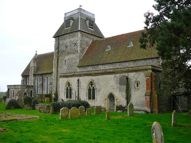
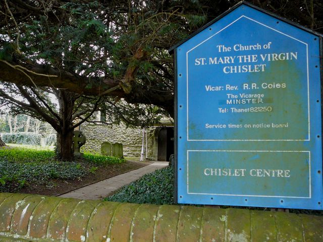
| Description | : | The Church of St Mary the Virgin at Chislet is a well-known local landmark, situated on a low rise above the surrounding marshland. The church is very large relative to the size of Chislet village, and has an unusual truncated spire on the central tower, with a flat, walled top, which suggests at first glance a French chateau. Originally mediaeval, the church was rebuilt in the 13th century; the tower is Norman. Inside the nave has been completely cleared, and is used as a social centre for the surrounding area. The restoration of 1866 swept away a rare west end... Read More |
frequently asked questions (FAQ):
-
Where is St Mary The Virgin Churchyard?
St Mary The Virgin Churchyard is located at Church Lane Chislet, City of Canterbury ,Kent , CT3 4DUEngland.
-
St Mary The Virgin Churchyard cemetery's updated grave count on graveviews.com?
84 memorials
-
Where are the coordinates of the St Mary The Virgin Churchyard?
Latitude: 51.3343610
Longitude: 1.1921020
Nearby Cemetories:
1. All Saints Churchyard
Stourmouth, Dover District, England
Coordinate: 51.3202600, 1.2365520
2. Stodmarsh St Marys Churchyard
Wickhambreaux, City of Canterbury, England
Coordinate: 51.3009500, 1.1836900
3. St Mary the Virgin Churchyard
Reculver, City of Canterbury, England
Coordinate: 51.3684750, 1.1766050
4. St Mildred Churchyard
Preston, Dover District, England
Coordinate: 51.2985000, 1.2173980
5. St Martin's Churchyard
Herne, City of Canterbury, England
Coordinate: 51.3497060, 1.1334370
6. St Martins
Herne, City of Canterbury, England
Coordinate: 51.3500600, 1.1333200
7. All Saints Churchyard
Westbere, City of Canterbury, England
Coordinate: 51.3065380, 1.1437670
8. St. Nicholas' Churchyard
St Nicholas at Wade, Thanet District, England
Coordinate: 51.3542160, 1.2517980
9. Herne Bay Cemetery
Herne Bay, City of Canterbury, England
Coordinate: 51.3571810, 1.1304820
10. St Nicholas-at-Wade Cemetery
St Nicholas at Wade, Thanet District, England
Coordinate: 51.3578344, 1.2534168
11. St Mary's Abbey
Reculver, City of Canterbury, England
Coordinate: 51.3795360, 1.1993770
12. Elmstone Churchyard
Preston, Dover District, England
Coordinate: 51.2967160, 1.2424980
13. Sturry Cemetery
Sturry, City of Canterbury, England
Coordinate: 51.3058100, 1.1277700
14. St Andrew Churchyard
Wickhambreaux, City of Canterbury, England
Coordinate: 51.2844400, 1.1822300
15. St Mary the Virgin Churchyard
Fordwich, City of Canterbury, England
Coordinate: 51.2958300, 1.1270530
16. St Nicholas Churchyard
Sturry, City of Canterbury, England
Coordinate: 51.2984830, 1.1201330
17. St Mary the Virgin Churchyard
Wingham, Dover District, England
Coordinate: 51.2721220, 1.2128950
18. St Mary the Virgin Church
Minster-in-Thanet, Thanet District, England
Coordinate: 51.3305810, 1.3156720
19. St. Nicholas Churchyard
Ash, Dover District, England
Coordinate: 51.2786800, 1.2786400
20. Minster Cemetery
Minster-in-Thanet, Thanet District, England
Coordinate: 51.3423100, 1.3160550
21. St James the Great Churchyard
Staple, Dover District, England
Coordinate: 51.2636300, 1.2515200
22. All Saints Churchyard
Birchington, Thanet District, England
Coordinate: 51.3736580, 1.3059360
23. St Gregory Churchyard
Canterbury, City of Canterbury, England
Coordinate: 51.2816050, 1.0887840
24. St Martin Churchyard
Canterbury, City of Canterbury, England
Coordinate: 51.2780170, 1.0937160