
| Memorials | : | 1 |
| Location | : | Charlton Musgrove, South Somerset District, England |
| Coordinate | : | 51.0870410, -2.3778130 |
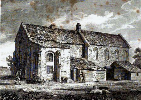
| Description | : | Built about 1243, the bell tower existed by 1374, the church was refitted and rebuilt in 1439, by John Stourton, the church being dedicated in 1443. The Priory was merged with Taunton in 1533, and the buildings became a residence soon afterwards. The remains consist of the nave and chancel. The nave has rich wagon roofs and the chapel a good fan vault. Some of the windows have been altered but those of the chapel are virtually complete. A blocked arch on South of nave may have led to a tower. The conventual buildings were on the North, and the... Read More |
frequently asked questions (FAQ):
-
Where is Stavordale Priory?
Stavordale Priory is located at Charlton Musgrove, South Somerset District ,Somerset ,England.
-
Stavordale Priory cemetery's updated grave count on graveviews.com?
1 memorials
-
Where are the coordinates of the Stavordale Priory?
Latitude: 51.0870410
Longitude: -2.3778130
Nearby Cemetories:
1. Saint John's Churchyard
Charlton Musgrove, South Somerset District, England
Coordinate: 51.0840723, -2.3869787
2. St. Michael Churchyard
Pen Selwood, South Somerset District, England
Coordinate: 51.0816300, -2.3499200
3. Saint Stephen Churchyard
Charlton Musgrove, South Somerset District, England
Coordinate: 51.0678630, -2.4008550
4. Bourton Village Cemetery
Bourton, North Dorset District, England
Coordinate: 51.0715890, -2.3337900
5. St George's Churchyard
Bourton, North Dorset District, England
Coordinate: 51.0715490, -2.3321690
6. St Peter Churchyard
Redlynch, South Somerset District, England
Coordinate: 51.0983279, -2.4299457
7. Church of St John the Baptist
Brewham, South Somerset District, England
Coordinate: 51.1236330, -2.4017130
8. St Lawrence Churchyard
Cucklington, South Somerset District, England
Coordinate: 51.0487190, -2.3507950
9. St Nicholas Churchyard
Silton, North Dorset District, England
Coordinate: 51.0630170, -2.3123390
10. Blessed Virgin Mary Churchyard
Bruton, South Somerset District, England
Coordinate: 51.1115790, -2.4520520
11. Bruton Abbey
Bruton, South Somerset District, England
Coordinate: 51.1114890, -2.4530300
12. Bruton Cemetery
Bruton, South Somerset District, England
Coordinate: 51.1208280, -2.4464270
13. St. Nicholas' Churchyard
Bratton Seymour, South Somerset District, England
Coordinate: 51.0679406, -2.4625400
14. St Leonard Churchyard and Extension
Pitcombe, South Somerset District, England
Coordinate: 51.0925600, -2.4684600
15. Saint Nicholas Churchyard
Holton, South Somerset District, England
Coordinate: 51.0401280, -2.4502641
16. St. Simon & St Jude Church Milton on Stour
Gillingham, North Dorset District, England
Coordinate: 51.0569980, -2.2843840
17. Civic Cemetery
Buckhorn Weston, North Dorset District, England
Coordinate: 51.0212440, -2.3484600
18. St John The Baptist Churchyard
Buckhorn Weston, North Dorset District, England
Coordinate: 51.0212870, -2.3481780
19. Church of the Holy Trinity
Bruton, South Somerset District, England
Coordinate: 51.1070450, -2.4843710
20. North Cheriton Cemetery
North Cheriton, South Somerset District, England
Coordinate: 51.0284840, -2.4389150
21. Saint John the Baptist Churchyard
North Cheriton, South Somerset District, England
Coordinate: 51.0309000, -2.4474000
22. Saint Mary The Virgin
Batcombe, Mendip District, England
Coordinate: 51.1495900, -2.4433900
23. Gillingham New Cemetery
Gillingham, North Dorset District, England
Coordinate: 51.0408540, -2.2811650
24. Gillingham Garden of Rememberance
Gillingham, North Dorset District, England
Coordinate: 51.0393211, -2.2795574