
| Memorials | : | 0 |
| Location | : | West Lulworth, Purbeck District, England |
| Coordinate | : | 50.6261650, -2.2468550 |
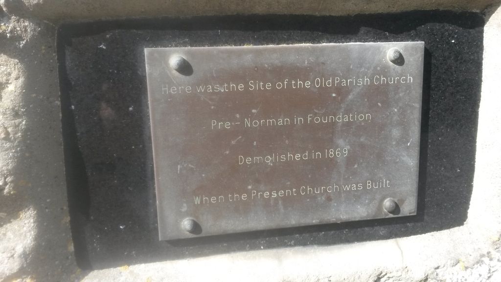
| Description | : | The original parish church on this site was very small and was demolished in 1869 when the new church was built on a larger site elsewhere in the village. However the old churchyard continued to be used for burials until at least 1927. |
frequently asked questions (FAQ):
-
Where is West Lulworth Old Churchyard?
West Lulworth Old Churchyard is located at West Lulworth, Purbeck District ,Dorset ,England.
-
West Lulworth Old Churchyard cemetery's updated grave count on graveviews.com?
0 memorials
-
Where are the coordinates of the West Lulworth Old Churchyard?
Latitude: 50.6261650
Longitude: -2.2468550
Nearby Cemetories:
1. Holy Trinity Churchyard
West Lulworth, Purbeck District, England
Coordinate: 50.6263000, -2.2515000
2. Lulworth Castle Chapel
East Lulworth, Purbeck District, England
Coordinate: 50.6399070, -2.2099960
3. St. Andrew's Parish Church
East Lulworth, Purbeck District, England
Coordinate: 50.6381750, -2.2081720
4. St. Christopher's Churchyard
Winfrith Newburgh, Purbeck District, England
Coordinate: 50.6585210, -2.2768930
5. St Nicholas Churchyard
Chaldon Herring, Purbeck District, England
Coordinate: 50.6473100, -2.2983330
6. St Mary's Churchyard
Tyneham, Purbeck District, England
Coordinate: 50.6230090, -2.1689980
7. Holy Rood Churchyard
Wool, Purbeck District, England
Coordinate: 50.6774970, -2.2169630
8. St Catherine-by-the-Sea
Weymouth, Weymouth and Portland Borough, England
Coordinate: 50.6342230, -2.3370640
9. Bindon Abbey Graveyard
Wool, Purbeck District, England
Coordinate: 50.6802430, -2.2097550
10. St. Michael's Church
Owermoigne, West Dorset District, England
Coordinate: 50.6671120, -2.3284310
11. St. Mary's Churchyard
East Stoke, Purbeck District, England
Coordinate: 50.6830000, -2.1818000
12. Monkey World
Bovington Camp, Purbeck District, England
Coordinate: 50.6994813, -2.2169029
13. St. Michael's and All Angels Churchyard
Steeple, Purbeck District, England
Coordinate: 50.6277090, -2.1267040
14. St Nicholas Churchyard
Moreton, Purbeck District, England
Coordinate: 50.7023040, -2.2786470
15. Moreton Cemetery
Moreton, Purbeck District, England
Coordinate: 50.7024300, -2.2790900
16. St. John the Evangelist
East Holme, Purbeck District, England
Coordinate: 50.6730910, -2.1440880
17. St John the Evangelist Churchyard
Poxwell, West Dorset District, England
Coordinate: 50.6555000, -2.3663000
18. Kimmeridge Churchyard
Kimmeridge, Purbeck District, England
Coordinate: 50.6192291, -2.1187155
19. St Osmund's Churchyard
Osmington, West Dorset District, England
Coordinate: 50.6459250, -2.3909880
20. Hill View Cemetery
Wareham, Purbeck District, England
Coordinate: 50.6828550, -2.1266310
21. Swyre Head
Chaldon Herring, Purbeck District, England
Coordinate: 50.6058320, -2.0944380
22. St. Martin's Churchyard
Broadmayne, West Dorset District, England
Coordinate: 50.6787530, -2.3856840
23. St Peter's Churchyard Church Knowle
Church Knowle, Purbeck District, England
Coordinate: 50.6370800, -2.0851140
24. Lady St Mary Churchyard
Wareham, Purbeck District, England
Coordinate: 50.6843130, -2.1077420