
| Memorials | : | 0 |
| Location | : | Wool, Purbeck District, England |
| Coordinate | : | 50.6802430, -2.2097550 |
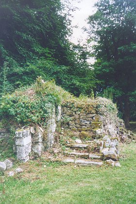
| Description | : | Ruins of Bindon Abbey Near Wool village Parish of Wool Dorset, England Originally founded in 1149 by William de Glastonia and known as Little Bindon being located near West Lulworth. A medieval Cistercian Abbey of Bindon was colonized by monks from Forde Abbey. In 1172, Roger de Newburgh and his wife, Matilda de Glastonia founded the Cistercian Abbey of Bindon in Dorsetshire, which they endowed with lands, as shown by their charter of that year. The abbey then sometimes called Great Bidon moved to this new location near Wool village. Matilda's grandfather, William de Glastonia contemplated and took steps toward founding Bindon Abby. His... Read More |
frequently asked questions (FAQ):
-
Where is Bindon Abbey Graveyard?
Bindon Abbey Graveyard is located at Wool, Purbeck District ,Dorset ,England.
-
Bindon Abbey Graveyard cemetery's updated grave count on graveviews.com?
0 memorials
-
Where are the coordinates of the Bindon Abbey Graveyard?
Latitude: 50.6802430
Longitude: -2.2097550
Nearby Cemetories:
1. Holy Rood Churchyard
Wool, Purbeck District, England
Coordinate: 50.6774970, -2.2169630
2. St. Mary's Churchyard
East Stoke, Purbeck District, England
Coordinate: 50.6830000, -2.1818000
3. Monkey World
Bovington Camp, Purbeck District, England
Coordinate: 50.6994813, -2.2169029
4. Lulworth Castle Chapel
East Lulworth, Purbeck District, England
Coordinate: 50.6399070, -2.2099960
5. St. Andrew's Parish Church
East Lulworth, Purbeck District, England
Coordinate: 50.6381750, -2.2081720
6. St. John the Evangelist
East Holme, Purbeck District, England
Coordinate: 50.6730910, -2.1440880
7. St. Christopher's Churchyard
Winfrith Newburgh, Purbeck District, England
Coordinate: 50.6585210, -2.2768930
8. St Nicholas Churchyard
Moreton, Purbeck District, England
Coordinate: 50.7023040, -2.2786470
9. Moreton Cemetery
Moreton, Purbeck District, England
Coordinate: 50.7024300, -2.2790900
10. Hill View Cemetery
Wareham, Purbeck District, England
Coordinate: 50.6828550, -2.1266310
11. West Lulworth Old Churchyard
West Lulworth, Purbeck District, England
Coordinate: 50.6261650, -2.2468550
12. Holy Trinity Churchyard
West Lulworth, Purbeck District, England
Coordinate: 50.6263000, -2.2515000
13. St Mary's Churchyard
Tyneham, Purbeck District, England
Coordinate: 50.6230090, -2.1689980
14. St Martin-on-the-Walls
Wareham, Purbeck District, England
Coordinate: 50.6888000, -2.1115000
15. Lady St Mary Churchyard
Wareham, Purbeck District, England
Coordinate: 50.6843130, -2.1077420
16. United Reformed Churchyard
Wareham, Purbeck District, England
Coordinate: 50.6860338, -2.1078591
17. St Nicholas Churchyard
Chaldon Herring, Purbeck District, England
Coordinate: 50.6473100, -2.2983330
18. Wareham Cemetery
Wareham, Purbeck District, England
Coordinate: 50.6848600, -2.1066320
19. St. John The Baptist Churchyard
Bere Regis, Purbeck District, England
Coordinate: 50.7521368, -2.2177036
20. St. Michael's and All Angels Churchyard
Steeple, Purbeck District, England
Coordinate: 50.6277090, -2.1267040
21. St. Laurence's Churchyard
Affpuddle, Purbeck District, England
Coordinate: 50.7426680, -2.2772280
22. St. Andrew's Churchyard
Bloxworth, Purbeck District, England
Coordinate: 50.7518333, -2.1706073
23. St. Michael's Church
Owermoigne, West Dorset District, England
Coordinate: 50.6671120, -2.3284310
24. Kimmeridge Churchyard
Kimmeridge, Purbeck District, England
Coordinate: 50.6192291, -2.1187155