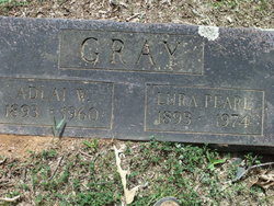
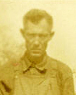
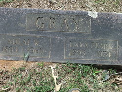
Adlai Wallace Gray
| Birth | : | 13 Jan 1893 Horatio, Sevier County, Arkansas, USA |
| Death | : | 5 Dec 1960 Broken Bow, McCurtain County, Oklahoma, USA |
| Burial | : | St. Mary Churchyard, Wedmore, Sedgemoor District, England |
| Coordinate | : | 51.2276790, -2.8110360 |
| Description | : | Funeral services were held at 2 p.m. Tuesday at the Broken Bow First Presbyterian Church for Adlai Wallace Gray, 67, long time Broken Bow barber. Rev. William R. Michell, assisted by Rev. Lawrence Langley, officiated. Mr. Gray died at 12:30 a.m. Monday at his home following an illness of several months duration. Born January 13, 1893 at Horatio, Ark., he had resided here since 1926. He owned the Palaco Barber Shop and had retired recently. He was a member of the Presbyterian Church. He is survived by his widow; one daughter, Mrs. Earl Taylor, Tulsa; one brother, C.B. Gray, Ariz; three sisters, Mrs.... Read More |
frequently asked questions (FAQ):
-
Where is Adlai Wallace Gray's memorial?
Adlai Wallace Gray's memorial is located at: St. Mary Churchyard, Wedmore, Sedgemoor District, England.
-
When did Adlai Wallace Gray death?
Adlai Wallace Gray death on 5 Dec 1960 in Broken Bow, McCurtain County, Oklahoma, USA
-
Where are the coordinates of the Adlai Wallace Gray's memorial?
Latitude: 51.2276790
Longitude: -2.8110360
Family Members:
Parent
Spouse
Siblings
Nearby Cemetories:
1. St. Mary Churchyard
Wedmore, Sedgemoor District, England
Coordinate: 51.2276790, -2.8110360
2. Baptist Churchyard
Wedmore, Sedgemoor District, England
Coordinate: 51.2260400, -2.8099800
3. St. Mary Magdalene Churchyard Extension
Wedmore, Sedgemoor District, England
Coordinate: 51.2327583, -2.8065246
4. Holy Trinity Churchyard
Blackford, Sedgemoor District, England
Coordinate: 51.2257800, -2.8483000
5. Allerton Churchyard
Chapel Allerton, Sedgemoor District, England
Coordinate: 51.2479860, -2.8482400
6. Christ Church Theale
Wedmore, Sedgemoor District, England
Coordinate: 51.2113720, -2.7631570
7. St. Leonard's Churchyard
Rodney Stoke, Mendip District, England
Coordinate: 51.2455140, -2.7431800
8. St Gregory Churchyard
Weare, Sedgemoor District, England
Coordinate: 51.2699900, -2.8408600
9. Holy Cross Churchyard
Mark, Sedgemoor District, England
Coordinate: 51.2269640, -2.8860140
10. St. Peter's Churchyard
Draycott, Mendip District, England
Coordinate: 51.2580900, -2.7523800
11. St. Andrew's Churchyard
Cheddar, Sedgemoor District, England
Coordinate: 51.2736740, -2.7761330
12. Cheddar Baptist Burial Ground
Cheddar, Sedgemoor District, England
Coordinate: 51.2767330, -2.7792010
13. St. Philip and St. James Churchyard
Burtle, Sedgemoor District, England
Coordinate: 51.1856232, -2.8665409
14. St Congar Churchyard
Badgworth, Sedgemoor District, England
Coordinate: 51.2699300, -2.8674000
15. Christ Church Churchyard
Henton, Mendip District, England
Coordinate: 51.2056460, -2.7256380
16. St Lawrence Churchyard
Westbury, Mendip District, England
Coordinate: 51.2354140, -2.7182630
17. St. Mary & All Saints Churchyard
Meare, Mendip District, England
Coordinate: 51.1715900, -2.7804100
18. St. John the Baptist Churchyard
Axbridge, Sedgemoor District, England
Coordinate: 51.2876300, -2.8162900
19. St. Michael Sanatorium Cemetery
Axbridge, Sedgemoor District, England
Coordinate: 51.2904100, -2.8056900
20. Holy Trinity Church
Godney, Mendip District, England
Coordinate: 51.1793400, -2.7377400
21. St. John the Baptist Churchyard
Biddisham, Sedgemoor District, England
Coordinate: 51.2764090, -2.8878950
22. Saint Andrew Churchyard
Compton Bishop, Sedgemoor District, England
Coordinate: 51.2943290, -2.8678900
23. St. Matthew Churchyard
Wookey, Mendip District, England
Coordinate: 51.2093000, -2.6893000
24. St. James the Great Churchyard
Winscombe, North Somerset Unitary Authority, England
Coordinate: 51.3059750, -2.8456900


