
Alice Alene Matheney Robbins
| Birth | : | 31 Mar 1902 Benton County, Tennessee, USA |
| Death | : | 25 Aug 1999 McKenzie, Carroll County, Tennessee, USA |
| Burial | : | St. Mary's Churchyard, Aston, East Hertfordshire District, England |
| Coordinate | : | 51.8875600, -0.1536200 |
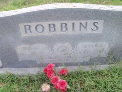
| Description | : | Married Willie B. Robbins 1916 The Camden Chronicle 2 Sep 1999 Obituary - "Funeral services for Alice Alene Robbins, age 97 of Big Sandy, were held Saturday, August 28, 1999 at 2 p.m. at Stockdale-Malin Chapel in Big Sandy with Bro. Larry Vine officiating. Burial was in Crooked Creek Cemetery. Mrs. Robbins died at McKenzie Methodist Hospital on Wednesday, August 25, 1999. She was born March 31, 1902 in Houston County, TN to the late James W. and Belle Triplett Smith Matheny. She was married to Willie Bee Robbins, who died in 1977. She was a homemaker and... Read More |
frequently asked questions (FAQ):
-
Where is Alice Alene Matheney Robbins's memorial?
Alice Alene Matheney Robbins's memorial is located at: St. Mary's Churchyard, Aston, East Hertfordshire District, England.
-
When did Alice Alene Matheney Robbins death?
Alice Alene Matheney Robbins death on 25 Aug 1999 in McKenzie, Carroll County, Tennessee, USA
-
Where are the coordinates of the Alice Alene Matheney Robbins's memorial?
Latitude: 51.8875600
Longitude: -0.1536200
Family Members:
Parent
Spouse

Siblings
Children
Flowers:


Nearby Cemetories:
1. St. Mary's Churchyard
Aston, East Hertfordshire District, England
Coordinate: 51.8875600, -0.1536200
2. Harwood Park Crematorium
Stevenage, Stevenage Borough, England
Coordinate: 51.8717680, -0.1698410
3. St Peter Churchyard
Benington, East Hertfordshire District, England
Coordinate: 51.8956030, -0.1167310
4. St Martin
Knebworth, North Hertfordshire District, England
Coordinate: 51.8654900, -0.1820500
5. All Saints Churchyard
Datchworth, East Hertfordshire District, England
Coordinate: 51.8575577, -0.1609916
6. Knebworth Cemetery
Knebworth, North Hertfordshire District, England
Coordinate: 51.8595280, -0.1867730
7. High Street Methodist Church
Stevenage, Stevenage Borough, England
Coordinate: 51.9080740, -0.2061550
8. Almond Lane Cemetery
Stevenage, Stevenage Borough, England
Coordinate: 51.9161780, -0.1954710
9. St. Mary the Virgin Churchyard
Walkern, East Hertfordshire District, England
Coordinate: 51.9226300, -0.1211300
10. St. Mary's Churchyard
Knebworth, North Hertfordshire District, England
Coordinate: 51.8723580, -0.2160890
11. Weston Road Cemetery
Stevenage, Stevenage Borough, England
Coordinate: 51.9217860, -0.1935160
12. St Nicholas Churchyard
Stevenage, Stevenage Borough, England
Coordinate: 51.9201590, -0.1974750
13. Ss Mary and Andrew Churchyard
Watton-at-Stone, East Hertfordshire District, England
Coordinate: 51.8533290, -0.1102500
14. St Lawrence Churchyard
Ardeley, East Hertfordshire District, England
Coordinate: 51.9274000, -0.0989000
15. All Saints Churchyard
Little Munden, East Hertfordshire District, England
Coordinate: 51.8795770, -0.0625920
16. St Mary the Virgin Churchyard
Stapleford, East Hertfordshire District, England
Coordinate: 51.8349710, -0.0973140
17. St Andrew Church
Bramfield, East Hertfordshire District, England
Coordinate: 51.8241000, -0.1266000
18. St. Mary's Churchyard
Welwyn, Welwyn Hatfield District, England
Coordinate: 51.8311660, -0.2151400
19. Welwyn Cemetery
Welwyn, Welwyn Hatfield District, England
Coordinate: 51.8331340, -0.2199520
20. Minsden Chapel
Hitchin, North Hertfordshire District, England
Coordinate: 51.9069200, -0.2595700
21. All Saints Churchyard
St Pauls Walden, North Hertfordshire District, England
Coordinate: 51.8865400, -0.2689200
22. St John the Baptist Churchyard
Cottered, East Hertfordshire District, England
Coordinate: 51.9458000, -0.0846000
23. St John the Evangelist Churchyard
Digswell, Welwyn Hatfield District, England
Coordinate: 51.8186190, -0.2051940
24. St. Nicholas' Churchyard
Great Munden, East Hertfordshire District, England
Coordinate: 51.8996010, -0.0316180