
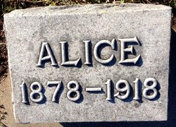

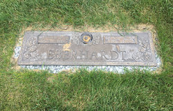
Alice Carey Abbott Eberhardt
| Birth | : | 28 Oct 1878 Glasco, Cloud County, Kansas, USA |
| Death | : | 28 Dec 1918 Glasco, Cloud County, Kansas, USA |
| Burial | : | St Mary's Churchyard, Burford, Shropshire Unitary Authority, England |
| Coordinate | : | 52.3087670, -2.6126000 |
| Description | : | Glasco Sun, Cloud County, Kansas, Jan. 2, 1919, page 4: Alice Carey Abbott was born near Glasco, October 28, 1878 and died at her home December 28, 1918, aged 40 years, 2 months. She grew to womanhood in this community where she was loved by all who knew her. She was left an orphan at the age of nine years after which she made her home with her grandmother Teasley. At the age of seventeen she began teaching school and taught seven successful terms in the rural schools of Cloud County, where she was always endeavoring to implant... Read More |
frequently asked questions (FAQ):
-
Where is Alice Carey Abbott Eberhardt's memorial?
Alice Carey Abbott Eberhardt's memorial is located at: St Mary's Churchyard, Burford, Shropshire Unitary Authority, England.
-
When did Alice Carey Abbott Eberhardt death?
Alice Carey Abbott Eberhardt death on 28 Dec 1918 in Glasco, Cloud County, Kansas, USA
-
Where are the coordinates of the Alice Carey Abbott Eberhardt's memorial?
Latitude: 52.3087670
Longitude: -2.6126000
Family Members:
Parent
Spouse
Siblings

Children
Flowers:


Nearby Cemetories:
1. St Mary's Churchyard
Burford, Shropshire Unitary Authority, England
Coordinate: 52.3087670, -2.6126000
2. St. Mary's Churchyard
Tenbury Wells, Malvern Hills District, England
Coordinate: 52.3120500, -2.5962400
3. St Michael's Churchyard Extension
Tenbury Wells, Malvern Hills District, England
Coordinate: 52.2941032, -2.6183906
4. St Michael and All Angels Churchyard
Tenbury Wells, Malvern Hills District, England
Coordinate: 52.2882600, -2.6137900
5. St. Mary Magdalene Churchyard
Little Hereford, Herefordshire Unitary Authority, England
Coordinate: 52.3112129, -2.6572039
6. St Michael and All Angels Churchyard
Rochford, Malvern Hills District, England
Coordinate: 52.3134240, -2.5454090
7. St Michael & All Angels Churchyard
Knighton-on-Teme, Malvern Hills District, England
Coordinate: 52.3260900, -2.5393500
8. St. Mary's Churchyard
Caynham, Shropshire Unitary Authority, England
Coordinate: 52.3558260, -2.6564540
9. St Marys Churchyard
Kyre, Malvern Hills District, England
Coordinate: 52.2685140, -2.5488360
10. St. Peter's Churchyard
Coreley, Shropshire Unitary Authority, England
Coordinate: 52.3627780, -2.5694950
11. St. Andrew, Ashford Bowdler.
Ashford Bowdler, Shropshire Unitary Authority, England
Coordinate: 52.3308770, -2.7065930
12. Knowbury, St Paul
Caynham, Shropshire Unitary Authority, England
Coordinate: 52.3734750, -2.6300130
13. St Peter & St Paul Churchyard
Eastham, Malvern Hills District, England
Coordinate: 52.3156100, -2.5046000
14. St. Peter's Churchyard
Stoke Bliss, Malvern Hills District, England
Coordinate: 52.2627200, -2.5121300
15. St. James the Less Churchyard
Kimbolton, Herefordshire Unitary Authority, England
Coordinate: 52.2507757, -2.6957349
16. St. John the Baptist Churchyard
Doddington, Cheshire East Unitary Authority, England
Coordinate: 52.3822068, -2.5651644
17. St Lawrence Churchyard
Lindridge, Malvern Hills District, England
Coordinate: 52.3180700, -2.4779300
18. St. Mary's Churchyard
Bitterley, Shropshire Unitary Authority, England
Coordinate: 52.3922280, -2.6319790
19. Hopton Bank Methodist Church Burial Ground
Hopton Wafers, Shropshire Unitary Authority, England
Coordinate: 52.3872950, -2.5584430
20. St. Peter and St. Paul
Leominster, Herefordshire Unitary Authority, England
Coordinate: 52.2704100, -2.7398260
21. St. Michael & All Angels Churchyard
Hopton Wafers, Shropshire Unitary Authority, England
Coordinate: 52.3857100, -2.5343700
22. St John the Baptist Churchyard
Mamble, Malvern Hills District, England
Coordinate: 52.3416520, -2.4586520
23. St Mary the Virgin
Cleobury Mortimer, Shropshire Unitary Authority, England
Coordinate: 52.3792280, -2.4803610
24. St Bartholomews Churchyard
Bayton, Malvern Hills District, England
Coordinate: 52.3562100, -2.4548200