

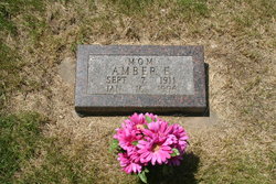
Amber Esther Fotheringham Paulson
| Birth | : | 7 Sep 1911 Academy, Charles Mix County, South Dakota, USA |
| Death | : | 16 Jan 1996 Platte Colony, Charles Mix County, South Dakota, USA |
| Burial | : | St. Nicholas' Churchyard, Rotherfield Greys, South Oxfordshire District, England |
| Coordinate | : | 51.5351017, -0.9541395 |
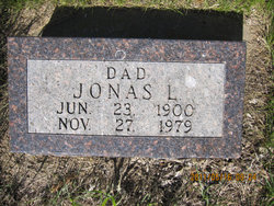
| Description | : | Amber Esther Fotheringham was born September 7, 1911 on a farm west of Academy to George and Elsie (Veale) Fotheringham. Amber attended Ward Academy before her marriage to Jonas Paulson on August 29, 1928 in Platte. After her marriage she moved to a farm 10 miles west and 1 1/2 miles south of Platte. Amber's husband, Jonas, passed away on November 27, 1979. In October of 1980 Amber moved to town and in 1993 became a resident of the Platte Nursing Home. Amber was a charter member of the Bethel Lutheran Brethren Church and was... Read More |
frequently asked questions (FAQ):
-
Where is Amber Esther Fotheringham Paulson's memorial?
Amber Esther Fotheringham Paulson's memorial is located at: St. Nicholas' Churchyard, Rotherfield Greys, South Oxfordshire District, England.
-
When did Amber Esther Fotheringham Paulson death?
Amber Esther Fotheringham Paulson death on 16 Jan 1996 in Platte Colony, Charles Mix County, South Dakota, USA
-
Where are the coordinates of the Amber Esther Fotheringham Paulson's memorial?
Latitude: 51.5351017
Longitude: -0.9541395
Family Members:
Parent
Spouse
Siblings

Children
Flowers:


Nearby Cemetories:
1. St. Nicholas' Churchyard
Rotherfield Greys, South Oxfordshire District, England
Coordinate: 51.5351017, -0.9541395
2. All Saints Churchyard
Rotherfield Peppard, South Oxfordshire District, England
Coordinate: 51.5280531, -0.9725009
3. Henley-on-Thames Cemetery
Henley-on-Thames, South Oxfordshire District, England
Coordinate: 51.5543570, -0.9271320
4. St. James's Churchyard
Bix and Assendon, South Oxfordshire District, England
Coordinate: 51.5610070, -0.9511270
5. St. Pauls Highmoor Cross
Highmoor, South Oxfordshire District, England
Coordinate: 51.5532740, -0.9910110
6. Holy Trinity Churchyard
Henley-on-Thames, South Oxfordshire District, England
Coordinate: 51.5338500, -0.9066600
7. Christ Church
Henley-on-Thames, South Oxfordshire District, England
Coordinate: 51.5347880, -0.9032820
8. St. Mary the Virgin Churchyard
Henley-on-Thames, South Oxfordshire District, England
Coordinate: 51.5377790, -0.9017520
9. St Margaret's Churchyard
Harpsden, South Oxfordshire District, England
Coordinate: 51.5219160, -0.9012270
10. St. John the Baptist Churchyard
Kidmore End, South Oxfordshire District, England
Coordinate: 51.5085170, -0.9951240
11. Kidmore End Cemetery
Kidmore End, South Oxfordshire District, England
Coordinate: 51.5071600, -0.9942160
12. St. James' Old Churchyard
South Oxfordshire District, England
Coordinate: 51.5769360, -0.9532550
13. All Saints Churchyard
Dunsden Green, South Oxfordshire District, England
Coordinate: 51.4917730, -0.9461650
14. St. John the Evangalist Churchyard
Stoke Row, South Oxfordshire District, England
Coordinate: 51.5510570, -1.0226630
15. Stoke Row Independant Chapel
Stoke Row, South Oxfordshire District, England
Coordinate: 51.5510570, -1.0226630
16. Stoke Row Independent Chapel Cemetery
Stoke Row, South Oxfordshire District, England
Coordinate: 51.5510570, -1.0226630
17. St. Mary the Virgin Churchyard
Fawley, Wycombe District, England
Coordinate: 51.5743000, -0.9140000
18. St. Bartholomew's Churchyard
Nettlebed, South Oxfordshire District, England
Coordinate: 51.5752360, -0.9936230
19. St. Peter and St. Paul Churchyard
Shiplake, South Oxfordshire District, England
Coordinate: 51.4980750, -0.8963940
20. Checkendon Churchyard
Checkendon, South Oxfordshire District, England
Coordinate: 51.5424461, -1.0449720
21. St. Mary's Churchyard
Wargrave, Wokingham Borough, England
Coordinate: 51.4998329, -0.8735808
22. Reading Cemetery and Crematorium
Caversham, Reading Borough, England
Coordinate: 51.4737690, -0.9546570
23. Caversham Cemetery
Caversham, Reading Borough, England
Coordinate: 51.4745850, -0.9758020
24. Stonor Park Cemetery
Henley-on-Thames, South Oxfordshire District, England
Coordinate: 51.5967370, -0.9289660