
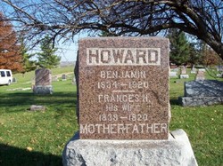


Benjamin Neal Howard
| Birth | : | 16 Nov 1834 Roane County, Tennessee, USA |
| Death | : | 26 May 1920 Maryville, Nodaway County, Missouri, USA |
| Burial | : | Zinnamon Cemetery, West Fork, Washington County, USA |
| Coordinate | : | 35.8230000, -94.2682000 |
| Plot | : | Sec 7, Row 18, S-N |
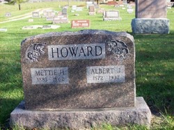
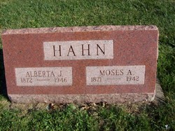
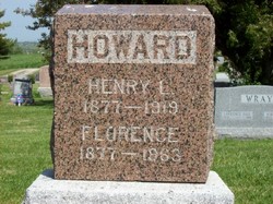
| Description | : | Son of John and Margaret Ramsour Howard. He married Frances Hawkins on October 18, 1857 in Nodaway County. Their children: Ida, Mag, Rosa who died in infancy, Sadie, Charles, Alberta, Albert, Henry, Harry and an infant who died in 1883. Benjamin Howard, sixty years a resident of Nodaway, dead. Was 85 years old--Passes away this morning at home of his daughter, Mrs. M. A. Hahn. Benjamin Howard, for over sixty years a resident of Nodaway county, died at 10 o'clock this morning at the home of his daughter, Mrs. M. A. Hahn, 1039 Dewey Avenue. Mr. Howard was past Eighty-five years... Read More |
frequently asked questions (FAQ):
-
Where is Benjamin Neal Howard's memorial?
Benjamin Neal Howard's memorial is located at: Zinnamon Cemetery, West Fork, Washington County, USA.
-
When did Benjamin Neal Howard death?
Benjamin Neal Howard death on 26 May 1920 in Maryville, Nodaway County, Missouri, USA
-
Where are the coordinates of the Benjamin Neal Howard's memorial?
Latitude: 35.8230000
Longitude: -94.2682000
Family Members:
Parent
Spouse

Siblings
Children


Nearby Cemetories:
1. Serenity Place Cemetery
Washington County, USA
Coordinate: 35.8312100, -94.2665000
2. Fall Creek Cemetery
Strickler, Washington County, USA
Coordinate: 35.8344110, -94.3098330
3. English Cemetery
Strickler, Washington County, USA
Coordinate: 35.7970000, -94.3015770
4. Dripping Springs Cemetery
Onda, Washington County, USA
Coordinate: 35.8584310, -94.2932080
5. Liberty 86 Cemetery
Strickler, Washington County, USA
Coordinate: 35.7844009, -94.2910995
6. Old Bethlehem Baptist Church Cemetery
Washington County, USA
Coordinate: 35.8481865, -94.2252731
7. McClelland Cemetery
Washington County, USA
Coordinate: 35.8635950, -94.2410980
8. Baker Cemetery
Onda, Washington County, USA
Coordinate: 35.8680992, -94.2910995
9. McDonald Cemetery
Onda, Washington County, USA
Coordinate: 35.8806000, -94.2799988
10. Morrow Cemetery
Washington County, USA
Coordinate: 35.8492012, -94.3380966
11. Dunkard Cemetery
Strickler, Washington County, USA
Coordinate: 35.7775002, -94.3217010
12. Low Gap Cemetery
West Fork, Washington County, USA
Coordinate: 35.8658218, -94.2063904
13. Brewster Simpson Cemetery
Washington County, USA
Coordinate: 35.8609620, -94.3390260
14. Choate Cemetery
Onda, Washington County, USA
Coordinate: 35.8938200, -94.2732500
15. Bugscuffle Cemetery
Strickler, Washington County, USA
Coordinate: 35.7841500, -94.3419460
16. Burris Cemetery
Washington County, USA
Coordinate: 35.8935000, -94.2482650
17. Scott Cemetery
Prairie Grove, Washington County, USA
Coordinate: 35.8591995, -94.3460999
18. Holcomb Cemetery
West Fork, Washington County, USA
Coordinate: 35.8954065, -94.2519087
19. Parks Cemetery
Hogeye, Washington County, USA
Coordinate: 35.8988991, -94.2906036
20. Clanton Cemetery
Floss, Washington County, USA
Coordinate: 35.7935110, -94.3619370
21. Howell Cemetery
Prairie Grove, Washington County, USA
Coordinate: 35.9056015, -94.2835999
22. Oak Grove Cemetery
Crawford County, USA
Coordinate: 35.7504005, -94.3262787
23. Union Star Cemetery
West Fork, Washington County, USA
Coordinate: 35.8922005, -94.2031021
24. Phillips Cemetery
Hogeye, Washington County, USA
Coordinate: 35.9119760, -94.2556360