
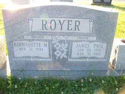
Bernadette M. Willard Royer
| Birth | : | 22 Apr 1924 USA |
| Death | : | 6 Jul 2013 Sabillasville, Frederick County, Maryland, USA |
| Burial | : | Cedar Grove Cemetery, Henderson County, USA |
| Coordinate | : | 35.4799600, -88.2678900 |
| Description | : | OBITUARY : BERNADETTE MARIE WILLARD ROYER, 89, of Sabillasville, Md., died Saturday, July 6, 2013, at the home of her granddaughter, Rebecca Smith. Born April 22, 1924, she was the daughter of the late Kenneth and Pauline (Kuhn) Willard. She was the wife of the late James Paul Royer, who died in 1988. She lived in the Highfield/Sabillasville area all her life. She was a dedicated homemaker, and in her younger years, she loved to bake. She was especially known for her good cooking, homemade cakes and bread. She was a member of St. John's United Church of Christ and read... Read More |
frequently asked questions (FAQ):
-
Where is Bernadette M. Willard Royer's memorial?
Bernadette M. Willard Royer's memorial is located at: Cedar Grove Cemetery, Henderson County, USA.
-
When did Bernadette M. Willard Royer death?
Bernadette M. Willard Royer death on 6 Jul 2013 in Sabillasville, Frederick County, Maryland, USA
-
Where are the coordinates of the Bernadette M. Willard Royer's memorial?
Latitude: 35.4799600
Longitude: -88.2678900
Family Members:
Parent

Spouse
Siblings
Flowers:


Nearby Cemetories:
1. Cedar Grove Cemetery
Henderson County, USA
Coordinate: 35.4799600, -88.2678900
2. Cedar Grove Pentecostal Cemetery
Sardis, Henderson County, USA
Coordinate: 35.4829530, -88.2698440
3. Granny Austin Cemetery
Scotts Hill, Henderson County, USA
Coordinate: 35.4949850, -88.2734300
4. Fellowship Church Cemetery
Scotts Hill, Henderson County, USA
Coordinate: 35.4965940, -88.2602540
5. Doe Creek Cemetery
Scotts Hill, Henderson County, USA
Coordinate: 35.4692990, -88.2474350
6. Prospect Church Cemetery
Sardis, Henderson County, USA
Coordinate: 35.4584950, -88.2683120
7. Pleasant View Cemetery
Sardis, Henderson County, USA
Coordinate: 35.4639730, -88.3019970
8. Bethel Cemetery
Scotts Hill, Decatur County, USA
Coordinate: 35.4963690, -88.2320790
9. Lowery-Doe Creek Cemetery
Decatur County, USA
Coordinate: 35.4483120, -88.2468900
10. Grandsire Holmes Cemetery
Scotts Hill, Henderson County, USA
Coordinate: 35.5140820, -88.2483620
11. Scotts Hill Pentecostal Church Cemetery
Scotts Hill, Decatur County, USA
Coordinate: 35.5065610, -88.2336080
12. Scotts Hill Church Cemetery
Scotts Hill, Henderson County, USA
Coordinate: 35.5189480, -88.2463960
13. Sardis Cemetery
Sardis, Henderson County, USA
Coordinate: 35.4366020, -88.2833100
14. Pafford - Scotts Hill Cemetery
Scotts Hill, Henderson County, USA
Coordinate: 35.5265450, -88.2515290
15. McBride Cemetery
Sardis, Henderson County, USA
Coordinate: 35.4406013, -88.3106003
16. Little Hurricane Cemetery
Sardis, Henderson County, USA
Coordinate: 35.4605060, -88.3302360
17. Liberty Church Cemetery
Scotts Hill, Decatur County, USA
Coordinate: 35.4466050, -88.2146570
18. Peace Chapel Cemetery
Scotts Hill, Decatur County, USA
Coordinate: 35.5214060, -88.2206280
19. Murphy Cemetery
Lick Skillet, Decatur County, USA
Coordinate: 35.4806930, -88.1983720
20. Ebenezer Cemetery
Henderson County, USA
Coordinate: 35.5353940, -88.2887670
21. Spring Hill Cemetery
Sardis, Henderson County, USA
Coordinate: 35.4277992, -88.3091965
22. Chumney Cemetery
Scotts Hill, Henderson County, USA
Coordinate: 35.5423140, -88.2460590
23. Decatur County Farm Cemetery
Scotts Hill, Decatur County, USA
Coordinate: 35.5078697, -88.1940994
24. Ridley Chapel Cemetery
Reagan, Henderson County, USA
Coordinate: 35.5026110, -88.3454170