
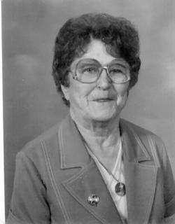
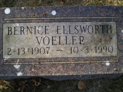
Bernice Marie Wylie Ellsworth Voeller
| Birth | : | 13 Feb 1907 Saunemin, Livingston County, Illinois, USA |
| Death | : | 3 Oct 1990 Aberdeen, Brown County, South Dakota, USA |
| Burial | : | Groby Village Cemetery, Groby, Hinckley and Bosworth Borough, England |
| Coordinate | : | 52.6542170, -1.2348310 |
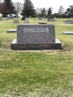
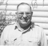
| Description | : | Bernice was married to William Ellsworth in Nov 7, 1925, he died in 1952. Bernice and William had four children, Ruth, Gary, Rita and Teddi. In 1960 she married George Voeller, he died in 1975. Both of her husbands are buried here at Wayside Cemetery, Frederick, S.D. BIOGRAPHY: Bernice Marie was born February 13, 1907 in Saunemin, Ill. to Fred and Ida (McCormick) Wylie, the only daughter of seven children. Fred and Ida moved their family, household, farm equipment, and livestock to Brown County March 10, 1910. They arrived with seven or eight other families on an "Immigrant... Read More |
frequently asked questions (FAQ):
-
Where is Bernice Marie Wylie Ellsworth Voeller's memorial?
Bernice Marie Wylie Ellsworth Voeller's memorial is located at: Groby Village Cemetery, Groby, Hinckley and Bosworth Borough, England.
-
When did Bernice Marie Wylie Ellsworth Voeller death?
Bernice Marie Wylie Ellsworth Voeller death on 3 Oct 1990 in Aberdeen, Brown County, South Dakota, USA
-
Where are the coordinates of the Bernice Marie Wylie Ellsworth Voeller's memorial?
Latitude: 52.6542170
Longitude: -1.2348310
Family Members:
Parent
Spouse
Siblings

Children

Flowers:


Nearby Cemetories:
1. Groby Village Cemetery
Groby, Hinckley and Bosworth Borough, England
Coordinate: 52.6542170, -1.2348310
2. St Philip and St James Churchyard
Ratby, Hinckley and Bosworth Borough, England
Coordinate: 52.6489370, -1.2433610
3. St. Philip and St. James Churchyard
Groby, Hinckley and Bosworth Borough, England
Coordinate: 52.6639220, -1.2278540
4. Kirby Muxloe Cemetery
Kirby Muxloe, Blaby District, England
Coordinate: 52.6373740, -1.2337780
5. St Bartholomew Churchyard
Kirby Muxloe, Blaby District, England
Coordinate: 52.6371750, -1.2320940
6. St Peter's Church
Glenfield, Blaby District, England
Coordinate: 52.6490490, -1.2063180
7. Newtown Linford Parish Cemetery
Newtown Linford, Charnwood Borough, England
Coordinate: 52.6812092, -1.2308014
8. Anstey Cemetery
Anstey, Charnwood Borough, England
Coordinate: 52.6680480, -1.1955570
9. All Saints Churchyard
Newtown Linford, Charnwood Borough, England
Coordinate: 52.6832010, -1.2292860
10. St Mary's Church
Anstey, Charnwood Borough, England
Coordinate: 52.6720090, -1.1888250
11. Bradgate House Chapelyard
Leicester, Leicester Unitary Authority, England
Coordinate: 52.6867020, -1.2110290
12. Gilroes Cemetery and Crematorium
Leicester, Leicester Unitary Authority, England
Coordinate: 52.6514359, -1.1721700
13. Markfield Cemetery
Markfield, Hinckley and Bosworth Borough, England
Coordinate: 52.6878983, -1.2707406
14. Saint Michael and All Angels Churchyard
Markfield, Hinckley and Bosworth Borough, England
Coordinate: 52.6869930, -1.2793315
15. St Martin Churchyard
Desford, Hinckley and Bosworth Borough, England
Coordinate: 52.6268250, -1.2943410
16. St. Peter's Churchyard
Thornton Abbey, North Lincolnshire Unitary Authority, England
Coordinate: 52.6646972, -1.3089069
17. St Peter's Churchyard
Bagworth, Hinckley and Bosworth Borough, England
Coordinate: 52.6646520, -1.3091920
18. St Peter's Churchyard
Braunstone, Blaby District, England
Coordinate: 52.6208940, -1.1812900
19. Desford Cemetery
Desford, Hinckley and Bosworth Borough, England
Coordinate: 52.6278100, -1.3068590
20. All Saints Churchyard
Thurcaston, Charnwood Borough, England
Coordinate: 52.6906870, -1.1647320
21. St Mary's Priory
Ulverscroft, Charnwood Borough, England
Coordinate: 52.7098890, -1.2598610
22. All Saints Church
Leicester, Leicester Unitary Authority, England
Coordinate: 52.6381940, -1.1403170
23. Leicester Abbey
Leicester, Leicester Unitary Authority, England
Coordinate: 52.6489600, -1.1369470
24. St. Nicholas Church
Leicester, Leicester Unitary Authority, England
Coordinate: 52.6351400, -1.1408940