
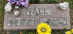
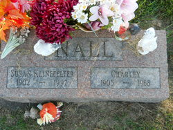
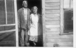
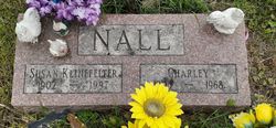
Charles Aron “Charley” Nall
| Birth | : | 26 Jul 1905 Chandlerville, Cass County, Illinois, USA |
| Death | : | 8 Aug 1968 |
| Burial | : | St Mary the Virgin Churchyard, Broughton, Cherwell District, England |
| Coordinate | : | 52.0417020, -1.3912030 |
| Plot | : | new 24 |
| Description | : | Charles Aron Nall was born in Chandlerville, Cass County, IL.. Charles "Charley"or"Chuck" as some knew him was the only child born to William Wilby and Mary "Molly" Cordelia Harbison Lewis Nall. Charles Aron and his parents moved to Anamosa Iowa when he was a young man, Charles Married Susan Marguerite Jones Klinfelter in Anamosa Iowa and they spent the rest of their life there and had no children. |
frequently asked questions (FAQ):
-
Where is Charles Aron “Charley” Nall's memorial?
Charles Aron “Charley” Nall's memorial is located at: St Mary the Virgin Churchyard, Broughton, Cherwell District, England.
-
When did Charles Aron “Charley” Nall death?
Charles Aron “Charley” Nall death on 8 Aug 1968 in
-
Where are the coordinates of the Charles Aron “Charley” Nall's memorial?
Latitude: 52.0417020
Longitude: -1.3912030
Family Members:
Parent

Spouse
Flowers:


Nearby Cemetories:
1. St Mary the Virgin Churchyard
Broughton, Cherwell District, England
Coordinate: 52.0417020, -1.3912030
2. St Nicholas Churchyard
Tadmarton, Cherwell District, England
Coordinate: 52.0377060, -1.4295690
3. St Mary's Churchyard
Bloxham, Cherwell District, England
Coordinate: 52.0181100, -1.3748900
4. St Peter's Churchyard
Drayton, Cherwell District, England
Coordinate: 52.0707360, -1.3764670
5. All Saints Churchyard
Wroxton, Cherwell District, England
Coordinate: 52.0726220, -1.3925790
6. Bodicote Cemetery
Bodicote, Cherwell District, England
Coordinate: 52.0391710, -1.3397380
7. Saint Laurence Churchyard
Milcombe, Cherwell District, England
Coordinate: 52.0083060, -1.4033990
8. St. Peter and St. Paul Churchyard
Swalcliffe, Cherwell District, England
Coordinate: 52.0380790, -1.4497340
9. St. John the Evangelist Churchyard
Banbury, Cherwell District, England
Coordinate: 52.0598790, -1.3400100
10. St. Mary the Virgin Churchyard
Banbury, Cherwell District, England
Coordinate: 52.0614620, -1.3391870
11. Saint John the Baptist Churchyard
Bodicote, Cherwell District, England
Coordinate: 52.0356100, -1.3305700
12. Southam Road Cemetery
Banbury, Cherwell District, England
Coordinate: 52.0679120, -1.3405760
13. St John the Evangelist
Milton, Cherwell District, England
Coordinate: 52.0117900, -1.3452510
14. South Newington St Peter ad Vincula
South Newington, Cherwell District, England
Coordinate: 51.9970000, -1.4082300
15. Adderbury Parish Cemetery
Adderbury, Cherwell District, England
Coordinate: 52.0139537, -1.3246874
16. St John's Churchyard
Barford St John, Cherwell District, England
Coordinate: 51.9955050, -1.3620350
17. St. Peters Churchyard
Hanwell, Cherwell District, England
Coordinate: 52.0887920, -1.3657000
18. St Etheldreda Churchyard
Horley, Cherwell District, England
Coordinate: 52.0924610, -1.3930320
19. Saint Giles
Wigginton, Cherwell District, England
Coordinate: 51.9966400, -1.4324000
20. Barford St. Michael Churchyard
Barford St Michael, Cherwell District, England
Coordinate: 51.9903200, -1.3711500
21. St Mary the Virgin Churchyard
Adderbury, Cherwell District, England
Coordinate: 52.0148420, -1.3152270
22. Banbury Crematorium
Banbury, Cherwell District, England
Coordinate: 52.0865540, -1.3406860
23. Hardwick Hill Cemetery
Banbury, Cherwell District, England
Coordinate: 52.0864530, -1.3381430
24. St Michael and All Angels Churchyard
Alkerton, Cherwell District, England
Coordinate: 52.0834080, -1.4509680