| Memorials | : | 0 |
| Location | : | Milcombe, Cherwell District, England |
| Coordinate | : | 52.0083060, -1.4033990 |
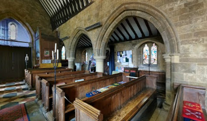
| Description | : | St Laurence, Milcombe In the center of the village is St. Laurence Church which was built in the 13 Century although little except the west tower survives from that period. Milcombe is just off the A361 Banbury to Chiping Norton Road about 5 miles southwest of Banbury. Grade II listed building with a modified Norman Tower and stained glass windows. Evidence of a 14th Century building over the entrance. The font is 15th Centu ry. A decorated rood screen and three bells hung for Ellacombe chiming. Re-ordered by GE Street, the Gothic Revival Architect, in the 1850s. In... Read More |
frequently asked questions (FAQ):
-
Where is Saint Laurence Churchyard?
Saint Laurence Churchyard is located at Main Road Milcombe, Cherwell District ,Oxfordshire , OX15 4RSEngland.
-
Saint Laurence Churchyard cemetery's updated grave count on graveviews.com?
0 memorials
-
Where are the coordinates of the Saint Laurence Churchyard?
Latitude: 52.0083060
Longitude: -1.4033990
Nearby Cemetories:
1. South Newington St Peter ad Vincula
South Newington, Cherwell District, England
Coordinate: 51.9970000, -1.4082300
2. St Mary's Churchyard
Bloxham, Cherwell District, England
Coordinate: 52.0181100, -1.3748900
3. Saint Giles
Wigginton, Cherwell District, England
Coordinate: 51.9966400, -1.4324000
4. Barford St. Michael Churchyard
Barford St Michael, Cherwell District, England
Coordinate: 51.9903200, -1.3711500
5. St John's Churchyard
Barford St John, Cherwell District, England
Coordinate: 51.9955050, -1.3620350
6. St Nicholas Churchyard
Tadmarton, Cherwell District, England
Coordinate: 52.0377060, -1.4295690
7. St Mary the Virgin Churchyard
Broughton, Cherwell District, England
Coordinate: 52.0417020, -1.3912030
8. St John the Evangelist
Milton, Cherwell District, England
Coordinate: 52.0117900, -1.3452510
9. St. Peter and St. Paul Churchyard
Swalcliffe, Cherwell District, England
Coordinate: 52.0380790, -1.4497340
10. St James Churchyard
Nether Worton, West Oxfordshire District, England
Coordinate: 51.9678100, -1.3807900
11. St Mary Churchyard
Swerford, West Oxfordshire District, England
Coordinate: 51.9773470, -1.4593150
12. Hook Norton Cemetery
Hook Norton, Cherwell District, England
Coordinate: 51.9969440, -1.4787690
13. Adderbury Parish Cemetery
Adderbury, Cherwell District, England
Coordinate: 52.0139537, -1.3246874
14. Bodicote Cemetery
Bodicote, Cherwell District, England
Coordinate: 52.0391710, -1.3397380
15. Deddington Cemetery
Deddington, Cherwell District, England
Coordinate: 51.9824490, -1.3338930
16. St Peters Churchyard
Hook Norton, Cherwell District, England
Coordinate: 51.9954200, -1.4842490
17. Holy Trinity Churchyard
Over Worton, West Oxfordshire District, England
Coordinate: 51.9598240, -1.3753620
18. St Michael and All Angels Churchyard
Great Tew, West Oxfordshire District, England
Coordinate: 51.9569280, -1.4205150
19. Saint John the Baptist Churchyard
Bodicote, Cherwell District, England
Coordinate: 52.0356100, -1.3305700
20. Hook Norton Baptist Burial Ground
Hook Norton, Cherwell District, England
Coordinate: 51.9953000, -1.4860900
21. St Mary the Virgin Churchyard
Adderbury, Cherwell District, England
Coordinate: 52.0148420, -1.3152270
22. Holy Trinity Churchyard
Sibford Gower, Cherwell District, England
Coordinate: 52.0374300, -1.4822670
23. Ss Peter and Paul Churchyard
Deddington, Cherwell District, England
Coordinate: 51.9817680, -1.3207470
24. St Johns Churchyard
Little Tew, West Oxfordshire District, England
Coordinate: 51.9540390, -1.4419230

