
Charles “Charlie” Minturn
| Birth | : | 2 Jan 1869 Sarpy County, Nebraska, USA |
| Death | : | 13 Jan 1880 Sarpy County, Nebraska, USA |
| Burial | : | Cheddar Baptist Burial Ground, Cheddar, Sedgemoor District, England |
| Coordinate | : | 51.2767330, -2.7792010 |
| Plot | : | Lot 66 Space 6 |
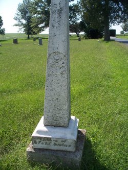
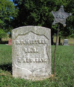
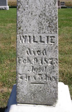
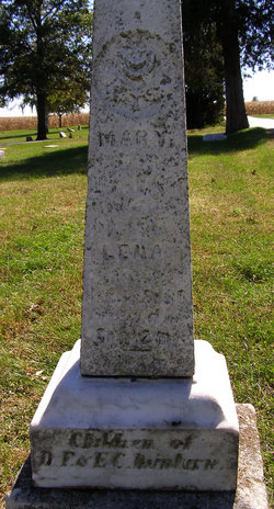
| Description | : | Charles was the son of Daniel Franklin Minturn, a veteran of the Civil War, and Emma Caroline Wood. Charles was one of seven children; four dying at a young age. Charles and sisters Mary and Lena died within a week of each other in Jan 1880 from diphtheria. An older brother, William, died in 1873. |
frequently asked questions (FAQ):
-
Where is Charles “Charlie” Minturn's memorial?
Charles “Charlie” Minturn's memorial is located at: Cheddar Baptist Burial Ground, Cheddar, Sedgemoor District, England.
-
When did Charles “Charlie” Minturn death?
Charles “Charlie” Minturn death on 13 Jan 1880 in Sarpy County, Nebraska, USA
-
Where are the coordinates of the Charles “Charlie” Minturn's memorial?
Latitude: 51.2767330
Longitude: -2.7792010
Family Members:
Parent
Siblings

Flowers:


Nearby Cemetories:
1. Cheddar Baptist Burial Ground
Cheddar, Sedgemoor District, England
Coordinate: 51.2767330, -2.7792010
2. St. Andrew's Churchyard
Cheddar, Sedgemoor District, England
Coordinate: 51.2736740, -2.7761330
3. St. Michael Sanatorium Cemetery
Axbridge, Sedgemoor District, England
Coordinate: 51.2904100, -2.8056900
4. St. Peter's Churchyard
Draycott, Mendip District, England
Coordinate: 51.2580900, -2.7523800
5. St. John the Baptist Churchyard
Axbridge, Sedgemoor District, England
Coordinate: 51.2876300, -2.8162900
6. St. Leonard's Churchyard
Rodney Stoke, Mendip District, England
Coordinate: 51.2455140, -2.7431800
7. St Leonard's Churchyard
Shipham, Sedgemoor District, England
Coordinate: 51.3130980, -2.8001830
8. St Gregory Churchyard
Weare, Sedgemoor District, England
Coordinate: 51.2699900, -2.8408600
9. Shipham Cemetery
Shipham, Sedgemoor District, England
Coordinate: 51.3201930, -2.7992390
10. St. Mary Magdalene Churchyard Extension
Wedmore, Sedgemoor District, England
Coordinate: 51.2327583, -2.8065246
11. St Michael and All Angels
Rowberrow, North Somerset Unitary Authority, England
Coordinate: 51.3240000, -2.7915000
12. St. James the Great Churchyard
Winscombe, North Somerset Unitary Authority, England
Coordinate: 51.3059750, -2.8456900
13. Allerton Churchyard
Chapel Allerton, Sedgemoor District, England
Coordinate: 51.2479860, -2.8482400
14. St. Mary Churchyard
Wedmore, Sedgemoor District, England
Coordinate: 51.2276790, -2.8110360
15. Baptist Churchyard
Wedmore, Sedgemoor District, England
Coordinate: 51.2260400, -2.8099800
16. St Congar Churchyard
Badgworth, Sedgemoor District, England
Coordinate: 51.2699300, -2.8674000
17. St Lawrence Churchyard
Westbury, Mendip District, England
Coordinate: 51.2354140, -2.7182630
18. Holy Trinity Churchyard
Burrington, North Somerset Unitary Authority, England
Coordinate: 51.3307830, -2.7496010
19. Saint Andrew Churchyard
Compton Bishop, Sedgemoor District, England
Coordinate: 51.2943290, -2.8678900
20. Winscombe and Sandford Cemetery
Winscombe, North Somerset Unitary Authority, England
Coordinate: 51.3223861, -2.8386889
21. Methodist Church Burial Ground
Churchill, North Somerset Unitary Authority, England
Coordinate: 51.3344140, -2.8000610
22. St Mary's Church
Lower Langford, North Somerset Unitary Authority, England
Coordinate: 51.3399805, -2.7813469
23. Saint John the Baptist Churchyard
Churchill, North Somerset Unitary Authority, England
Coordinate: 51.3384750, -2.8092710
24. St Andrew Churchyard
Blagdon, North Somerset Unitary Authority, England
Coordinate: 51.3275610, -2.7127710