
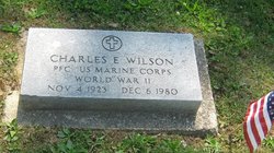
Charles Edward Wilson
| Birth | : | 4 Nov 1923 Vigo County, Indiana, USA |
| Death | : | 6 Dec 1980 Sullivan, Sullivan County, Indiana, USA |
| Burial | : | St. Mary Churchyard, Wedmore, Sedgemoor District, England |
| Coordinate | : | 51.2276790, -2.8110360 |
| Plot | : | Section L |
| Inscription | : | PFC US Marine Corps / World War II |
frequently asked questions (FAQ):
-
Where is Charles Edward Wilson's memorial?
Charles Edward Wilson's memorial is located at: St. Mary Churchyard, Wedmore, Sedgemoor District, England.
-
When did Charles Edward Wilson death?
Charles Edward Wilson death on 6 Dec 1980 in Sullivan, Sullivan County, Indiana, USA
-
Where are the coordinates of the Charles Edward Wilson's memorial?
Latitude: 51.2276790
Longitude: -2.8110360
Family Members:
Parent

Spouse

Siblings
Flowers:


Nearby Cemetories:
1. St. Mary Churchyard
Wedmore, Sedgemoor District, England
Coordinate: 51.2276790, -2.8110360
2. Baptist Churchyard
Wedmore, Sedgemoor District, England
Coordinate: 51.2260400, -2.8099800
3. St. Mary Magdalene Churchyard Extension
Wedmore, Sedgemoor District, England
Coordinate: 51.2327583, -2.8065246
4. Holy Trinity Churchyard
Blackford, Sedgemoor District, England
Coordinate: 51.2257800, -2.8483000
5. Allerton Churchyard
Chapel Allerton, Sedgemoor District, England
Coordinate: 51.2479860, -2.8482400
6. Christ Church Theale
Wedmore, Sedgemoor District, England
Coordinate: 51.2113720, -2.7631570
7. St. Leonard's Churchyard
Rodney Stoke, Mendip District, England
Coordinate: 51.2455140, -2.7431800
8. St Gregory Churchyard
Weare, Sedgemoor District, England
Coordinate: 51.2699900, -2.8408600
9. Holy Cross Churchyard
Mark, Sedgemoor District, England
Coordinate: 51.2269640, -2.8860140
10. St. Peter's Churchyard
Draycott, Mendip District, England
Coordinate: 51.2580900, -2.7523800
11. St. Andrew's Churchyard
Cheddar, Sedgemoor District, England
Coordinate: 51.2736740, -2.7761330
12. Cheddar Baptist Burial Ground
Cheddar, Sedgemoor District, England
Coordinate: 51.2767330, -2.7792010
13. St. Philip and St. James Churchyard
Burtle, Sedgemoor District, England
Coordinate: 51.1856232, -2.8665409
14. St Congar Churchyard
Badgworth, Sedgemoor District, England
Coordinate: 51.2699300, -2.8674000
15. Christ Church Churchyard
Henton, Mendip District, England
Coordinate: 51.2056460, -2.7256380
16. St Lawrence Churchyard
Westbury, Mendip District, England
Coordinate: 51.2354140, -2.7182630
17. St. Mary & All Saints Churchyard
Meare, Mendip District, England
Coordinate: 51.1715900, -2.7804100
18. St. John the Baptist Churchyard
Axbridge, Sedgemoor District, England
Coordinate: 51.2876300, -2.8162900
19. St. Michael Sanatorium Cemetery
Axbridge, Sedgemoor District, England
Coordinate: 51.2904100, -2.8056900
20. Holy Trinity Church
Godney, Mendip District, England
Coordinate: 51.1793400, -2.7377400
21. St. John the Baptist Churchyard
Biddisham, Sedgemoor District, England
Coordinate: 51.2764090, -2.8878950
22. Saint Andrew Churchyard
Compton Bishop, Sedgemoor District, England
Coordinate: 51.2943290, -2.8678900
23. St. Matthew Churchyard
Wookey, Mendip District, England
Coordinate: 51.2093000, -2.6893000
24. St. James the Great Churchyard
Winscombe, North Somerset Unitary Authority, England
Coordinate: 51.3059750, -2.8456900