
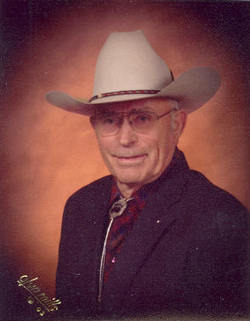

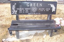
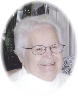
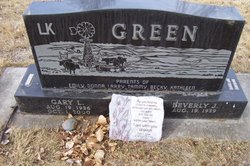
Charles Robert “Sonny” Green
| Birth | : | 19 Nov 1929 Miles City, Custer County, Montana, USA |
| Death | : | 16 Jul 2006 Miles City, Custer County, Montana, USA |
| Burial | : | Herne Bay Cemetery, Herne Bay, City of Canterbury, England |
| Coordinate | : | 51.3571810, 1.1304820 |
| Description | : | Sonny was born in Miles City, Montana on November 19, 1929, the son of Loy and Evelyn (Beckman) Green. He attended Loesch School near Volborg then went to high school at Custer County District High School in Miles City. After high school, Sonny ranched and worked as an apprentice Blacksmith on the Milwaukee shops in Milwaukee, Wisconsin. He was drafted into the United States Army in September of 1951. Sonny married Jeanne Hough on February 24, 1952 in Miles City, Montana. Two weeks later, Sonny left for a 14 month tour in Korea... Read More |
frequently asked questions (FAQ):
-
Where is Charles Robert “Sonny” Green's memorial?
Charles Robert “Sonny” Green's memorial is located at: Herne Bay Cemetery, Herne Bay, City of Canterbury, England.
-
When did Charles Robert “Sonny” Green death?
Charles Robert “Sonny” Green death on 16 Jul 2006 in Miles City, Custer County, Montana, USA
-
Where are the coordinates of the Charles Robert “Sonny” Green's memorial?
Latitude: 51.3571810
Longitude: 1.1304820
Family Members:
Parent


Siblings
Flowers:


Nearby Cemetories:
1. Herne Bay Cemetery
Herne Bay, City of Canterbury, England
Coordinate: 51.3571810, 1.1304820
2. St Martins
Herne, City of Canterbury, England
Coordinate: 51.3500600, 1.1333200
3. St Martin's Churchyard
Herne, City of Canterbury, England
Coordinate: 51.3497060, 1.1334370
4. St Mary the Virgin Churchyard
Reculver, City of Canterbury, England
Coordinate: 51.3684750, 1.1766050
5. St John the Baptist Churchyard
Swalecliffe, City of Canterbury, England
Coordinate: 51.3645500, 1.0667200
6. St Mary The Virgin Churchyard
Chislet, City of Canterbury, England
Coordinate: 51.3343610, 1.1921020
7. St Mary's Abbey
Reculver, City of Canterbury, England
Coordinate: 51.3795360, 1.1993770
8. All Saints Churchyard
Westbere, City of Canterbury, England
Coordinate: 51.3065380, 1.1437670
9. Sturry Cemetery
Sturry, City of Canterbury, England
Coordinate: 51.3058100, 1.1277700
10. All Saints Churchyard
Whitstable, City of Canterbury, England
Coordinate: 51.3558090, 1.0396670
11. St Nicholas Churchyard
Sturry, City of Canterbury, England
Coordinate: 51.2984830, 1.1201330
12. Whitstable Cemetery
Whitstable, City of Canterbury, England
Coordinate: 51.3529870, 1.0338530
13. St Mary the Virgin Churchyard
Fordwich, City of Canterbury, England
Coordinate: 51.2958300, 1.1270530
14. Stodmarsh St Marys Churchyard
Wickhambreaux, City of Canterbury, England
Coordinate: 51.3009500, 1.1836900
15. St Alphege Churchyard
Whitstable, City of Canterbury, England
Coordinate: 51.3576330, 1.0251080
16. St Cosmus and St Damian Churchyard
Blean, City of Canterbury, England
Coordinate: 51.3052720, 1.0530480
17. St. Nicholas' Churchyard
St Nicholas at Wade, Thanet District, England
Coordinate: 51.3542160, 1.2517980
18. All Saints Churchyard
Stourmouth, Dover District, England
Coordinate: 51.3202600, 1.2365520
19. St Nicholas-at-Wade Cemetery
St Nicholas at Wade, Thanet District, England
Coordinate: 51.3578344, 1.2534168
20. St Gregory's Priory (defunct)
Canterbury, City of Canterbury, England
Coordinate: 51.2831127, 1.0855358
21. St. John the Baptist Hospital Chapelyard
Canterbury, City of Canterbury, England
Coordinate: 51.2832713, 1.0837677
22. St Andrew Churchyard
Wickhambreaux, City of Canterbury, England
Coordinate: 51.2844400, 1.1822300
23. St Gregory Churchyard
Canterbury, City of Canterbury, England
Coordinate: 51.2816050, 1.0887840
24. St Mildred Churchyard
Preston, Dover District, England
Coordinate: 51.2985000, 1.2173980