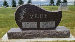
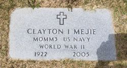
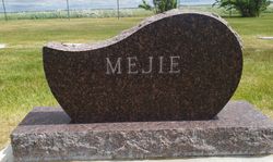
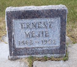
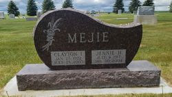
Clayton Irwin “Clayt” Mejie
| Birth | : | 25 Jan 1922 Montana, USA |
| Death | : | 25 Jul 2005 Libby, Lincoln County, Montana, USA |
| Burial | : | St George's Anglican Churchyard, Kirwee, Selwyn District, New Zealand |
| Coordinate | : | -43.4940826, 172.2182446 |
| Description | : | LIBBY - Clayton "Clayt" Irwin Mejie, 83, of Libby, formerly of Hogeland, died Monday, July 25, 2005, at a Libby care center of natural causes. A memorial service was held at American Lutheran Church in Turner. Inurnment with military honors was held at Wing Cemetery. Clayt was born Jan. 25, 1922, in a squatter's shack in Tweet to Lottie Mae (Davis) Ward and Ernest Mejie. From the time he was 3, Clayt lived with his Aunt Rose and Uncle Clayt on the family farm near Hogeland. He was baptized and confirmed at American Lutheran Church in Turner. He attended Wing School and... Read More |
frequently asked questions (FAQ):
-
Where is Clayton Irwin “Clayt” Mejie's memorial?
Clayton Irwin “Clayt” Mejie's memorial is located at: St George's Anglican Churchyard, Kirwee, Selwyn District, New Zealand.
-
When did Clayton Irwin “Clayt” Mejie death?
Clayton Irwin “Clayt” Mejie death on 25 Jul 2005 in Libby, Lincoln County, Montana, USA
-
Where are the coordinates of the Clayton Irwin “Clayt” Mejie's memorial?
Latitude: -43.4940826
Longitude: 172.2182446
Family Members:
Parent
Spouse
Flowers:
Nearby Cemetories:
1. St George's Anglican Churchyard
Kirwee, Selwyn District, New Zealand
Coordinate: -43.4940826, 172.2182446
2. Kirwee Cemetery
Kirwee, Selwyn District, New Zealand
Coordinate: -43.4935800, 172.2118100
3. St Matthew's Churchyard
Courtenay, Selwyn District, New Zealand
Coordinate: -43.4819060, 172.2792350
4. Halkett Presbyterian Churchyard
Halkett, Selwyn District, New Zealand
Coordinate: -43.5011000, 172.3220900
5. St Joseph's Catholic Cemetery
Darfield, Selwyn District, New Zealand
Coordinate: -43.4918030, 172.1081060
6. Trinity Church Columbarium
Darfield, Selwyn District, New Zealand
Coordinate: -43.4888350, 172.1052750
7. Kimberley Cemetery
Darfield, Selwyn District, New Zealand
Coordinate: -43.4485800, 172.1208100
8. Greendale Cemetery
Greendale, Selwyn District, New Zealand
Coordinate: -43.5447560, 172.0772460
9. St Paul's Anglican Church Cemetery
West Melton, Selwyn District, New Zealand
Coordinate: -43.5261700, 172.3701800
10. Weedons Cemetery
Weedons, Selwyn District, New Zealand
Coordinate: -43.5670010, 172.4015870
11. Waddington Cemetery
Waddington, Selwyn District, New Zealand
Coordinate: -43.4001830, 172.0424870
12. Brookside Cemetery
Brookside, Selwyn District, New Zealand
Coordinate: -43.6751800, 172.2683700
13. Dunsandel Cemetery
Dunsandel, Selwyn District, New Zealand
Coordinate: -43.6710940, 172.1382620
14. Yaldhurst Cemetery
Yaldhurst, Christchurch City, New Zealand
Coordinate: -43.5109640, 172.4765980
15. St Saviours Churchyard
Templeton, Christchurch City, New Zealand
Coordinate: -43.5501420, 172.4714620
16. Oxford Cemetery
Oxford, Waimakariri District, New Zealand
Coordinate: -43.2976980, 172.2000500
17. South Malvern Cemetery
Glentunnel, Selwyn District, New Zealand
Coordinate: -43.4807300, 171.9475200
18. Hororata Cemetery
Hororata, Selwyn District, New Zealand
Coordinate: -43.5196600, 171.9461100
19. St Johns Churchyard
Hororata, Selwyn District, New Zealand
Coordinate: -43.5189100, 171.9457550
20. St Luke's Anglican Churchyard
Brookside, Selwyn District, New Zealand
Coordinate: -43.6903100, 172.3029000
21. Cust Anglican Cemetery
Cust, Waimakariri District, New Zealand
Coordinate: -43.3103410, 172.3545810
22. St Mary's Churchyard
Springston, Selwyn District, New Zealand
Coordinate: -43.6446560, 172.4263590
23. Shands Road Cemetery
Prebbleton, Selwyn District, New Zealand
Coordinate: -43.5792540, 172.4888630
24. Cust-West Eyreton Cemetery
Cust, Waimakariri District, New Zealand
Coordinate: -43.3183330, 172.3877170

