
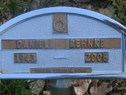
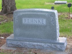
Daniel K Rehnke
| Birth | : | 18 Oct 1943 Sioux Falls, Minnehaha County, South Dakota, USA |
| Death | : | 19 Jan 2006 Redfield, Spink County, South Dakota, USA |
| Burial | : | St Mary Churchyard, Stelling Minnis, Shepway District, England |
| Coordinate | : | 51.1963830, 1.0644830 |
| Plot | : | Div F, Blk 043, Lot 001, Grave 003 |
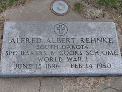
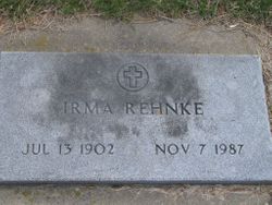
| Description | : | Redfield - Daniel K. Rehnke, 62, of Redfield, S.D., died Thursday, Jan. 19, 2006, at his home. His funeral will be Tuesday, Jan. 24, 2006, at 10:30 a.m. at Messiah Lutheran Church in Redfield. Rev. Peter M. Utecht will officiate. Burial will be in Greenlawn Cemetery in Redfield. Visitation will be Monday from 2-8 p.m. at Thelen Funeral Home in Redfield. Dan was born Oct. 18, 1943, in Sioux Falls, S.D., to Alfred and Irma (Green) Rehnke. He graduated from Redfield High School and lived most of his life in Redfield. He worked at Redfield Sales, Wagner Motors, Schroeder Motors,... Read More |
frequently asked questions (FAQ):
-
Where is Daniel K Rehnke's memorial?
Daniel K Rehnke's memorial is located at: St Mary Churchyard, Stelling Minnis, Shepway District, England.
-
When did Daniel K Rehnke death?
Daniel K Rehnke death on 19 Jan 2006 in Redfield, Spink County, South Dakota, USA
-
Where are the coordinates of the Daniel K Rehnke's memorial?
Latitude: 51.1963830
Longitude: 1.0644830
Family Members:
Parent
Flowers:


Nearby Cemetories:
1. St Mary Churchyard
Stelling Minnis, Shepway District, England
Coordinate: 51.1963830, 1.0644830
2. St Peter and St Paul Churchyard
Upper Hardres, City of Canterbury, England
Coordinate: 51.2152380, 1.0811020
3. All Saints Churchyard
Petham, City of Canterbury, England
Coordinate: 51.2206030, 1.0496330
4. St Bartholomew Churchyard
Waltham, City of Canterbury, England
Coordinate: 51.1961680, 1.0223940
5. St Mary's Churchyard
Lower Hardres, City of Canterbury, England
Coordinate: 51.2371410, 1.0821320
6. St Mary the Blessed Virgin Churchyard
Crundale, Ashford Borough, England
Coordinate: 51.1985000, 0.9842100
7. Elham Methodist Church
Elham, Shepway District, England
Coordinate: 51.1542930, 1.1113970
8. St. Mary the Virgin Churchyard
Hastingleigh, Ashford Borough, England
Coordinate: 51.1610820, 1.0047880
9. St. Mary the Virgin Churchyard
Elham, Shepway District, England
Coordinate: 51.1521870, 1.1118610
10. St Mary Churchyard
Bishopsbourne, City of Canterbury, England
Coordinate: 51.2307620, 1.1323170
11. St Augustine Hospital Burial Ground
Chartham, City of Canterbury, England
Coordinate: 51.2480170, 1.0342770
12. Elham Burial Ground
Elham, Shepway District, England
Coordinate: 51.1497940, 1.1115020
13. St. Mary's Churchyard
Nackington, City of Canterbury, England
Coordinate: 51.2498670, 1.0892370
14. St. Giles Churchyard
Kingston, City of Canterbury, England
Coordinate: 51.2181750, 1.1463980
15. St Peter Churchyard
Bridge, City of Canterbury, England
Coordinate: 51.2443730, 1.1271000
16. St John the Baptist Churchyard
Barham, City of Canterbury, England
Coordinate: 51.2065410, 1.1620830
17. St John the Baptist Church Cemetery
Barham, City of Canterbury, England
Coordinate: 51.2056600, 1.1629900
18. St. Mary the Virgin Churchyard
Chartham, City of Canterbury, England
Coordinate: 51.2558720, 1.0180810
19. St Mary Magdalene Churchyard
Denton, Dover District, England
Coordinate: 51.1767118, 1.1694535
20. St Mary the Blessed Virgin Churchyard
Brabourne, Ashford Borough, England
Coordinate: 51.1358410, 1.0054050
21. St Mary and St Ethelburga Churchyard
Lyminge, Shepway District, England
Coordinate: 51.1262670, 1.0869770
22. Barham Crematorium
Barham, City of Canterbury, England
Coordinate: 51.1972610, 1.1800310
23. St Mary Churchyard
Patrixbourne, City of Canterbury, England
Coordinate: 51.2534430, 1.1364840
24. Aylesham Cemetery
Aylesham, Dover District, England
Coordinate: 51.2126910, 1.1781980