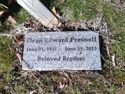
Dean Edward Presnell
| Birth | : | 21 Jun 1931 Washington, USA |
| Death | : | 14 Jun 2013 Auburn, Placer County, California, USA |
| Burial | : | Georgetown-Renke Cemetery Annex, Georgetown, El Dorado County, USA |
| Coordinate | : | 38.8964610, -120.9116240 |
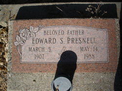
| Description | : | In extreme pain from recent surgery and having had macular degenerate eye disease for years and was almost blind, two days after his second wife Rosa Lee Presnell, died of cancer, Dean Presnell took his own life by shooting himself in the head. He leaves behind a daughter Shirley Ann Kekow of Woodland, California, three grandchildren, Brian Serb, Ken Kekow, and Kimberly Kekow, and a niece Deborah Cowden. He was proceeded in death by his father Edward Presnell, mother Irene Tracy and his first wife Joyce Ann Beasley Presnell. |
frequently asked questions (FAQ):
-
Where is Dean Edward Presnell's memorial?
Dean Edward Presnell's memorial is located at: Georgetown-Renke Cemetery Annex, Georgetown, El Dorado County, USA.
-
When did Dean Edward Presnell death?
Dean Edward Presnell death on 14 Jun 2013 in Auburn, Placer County, California, USA
-
Where are the coordinates of the Dean Edward Presnell's memorial?
Latitude: 38.8964610
Longitude: -120.9116240
Family Members:
Flowers:
Nearby Cemetories:
1. Georgetown-Renke Cemetery Annex
Georgetown, El Dorado County, USA
Coordinate: 38.8964610, -120.9116240
2. Greenwood Pioneer Cemetery
Greenwood, El Dorado County, USA
Coordinate: 38.8985786, -120.9099274
3. Spanish Dry Diggings Cemetery
Greenwood, El Dorado County, USA
Coordinate: 38.9431600, -120.9158000
4. Georgetown Pioneer Cemetery
Georgetown, El Dorado County, USA
Coordinate: 38.9068108, -120.8430862
5. Alabama Flat Cemetery
Garden Valley, El Dorado County, USA
Coordinate: 38.8413660, -120.8770510
6. Georgia Slide Cemetery
Georgetown, El Dorado County, USA
Coordinate: 38.9218063, -120.8377838
7. Carmelite Monastery Cemetery
Georgetown, El Dorado County, USA
Coordinate: 38.9273300, -120.8173840
8. Bayley Family Cemetery
Pilot Hill, El Dorado County, USA
Coordinate: 38.8438800, -121.0148900
9. Uniontown Cemetery
Lotus, El Dorado County, USA
Coordinate: 38.7994003, -120.9111023
10. Indian Creek Cemetery
Coloma, El Dorado County, USA
Coordinate: 38.7974230, -120.9104530
11. Saint John's Catholic Churchyard
Coloma, El Dorado County, USA
Coordinate: 38.7975311, -120.8919678
12. James Marshall Monument and Gravesite
Coloma, El Dorado County, USA
Coordinate: 38.7963104, -120.8953781
13. Pilot Hill Cemetery
Pilot Hill, El Dorado County, USA
Coordinate: 38.8301010, -121.0093307
14. Spring Garden Indian Cemetery
Foresthill, Placer County, USA
Coordinate: 38.9998620, -120.9049310
15. Pioneer Cemetery
Coloma, El Dorado County, USA
Coordinate: 38.7943192, -120.8894577
16. Esoteric Fraternity Cemetery
Applegate, Placer County, USA
Coordinate: 38.9946190, -120.9687490
17. Todd Valley Cemetery
Placer County, USA
Coordinate: 38.9970900, -120.8541000
18. Clipper Gap Cemetery
Clipper Gap, Placer County, USA
Coordinate: 38.9784880, -121.0256590
19. Kelsey Cemetery
Kelsey, El Dorado County, USA
Coordinate: 38.7949791, -120.8200073
20. First Congregational Church Memorial Garden
Auburn, Placer County, USA
Coordinate: 38.9118660, -121.0711770
21. Placer County Hospital Cemetery
Auburn, Placer County, USA
Coordinate: 38.9045120, -121.0721320
22. Josephine Mine Cemetery
Volcanoville, El Dorado County, USA
Coordinate: 38.9798000, -120.7892170
23. Bethlehem Lutheran Church Columbarium
Auburn, Placer County, USA
Coordinate: 38.8932350, -121.0749690
24. Clark Ashton Smith Gravesite
Auburn, Placer County, USA
Coordinate: 38.8952100, -121.0770500


