
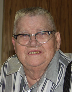

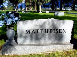
Donald G. Mattheisen
| Birth | : | 2 Mar 1928 |
| Death | : | 8 May 2003 |
| Burial | : | Bishops Corner Cemetery, Southbridge, Selwyn District, New Zealand |
| Coordinate | : | -43.7824100, 172.2422900 |
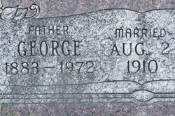
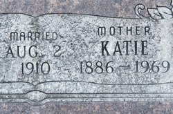
| Inscription | : | "Married May 2, 1954" |
| Description | : | Donald “Don” G. Mattheisen, 75, of Columbia Falls passed away Thursday, May 8th, 2003 at the Kalispell Regional Medical Center after a long battle with lung problems. Donald was born to George and Katherine Lee Mattheisen on March 2, 1928 at his home near Columbia Falls. He attended the Badrock Grade School and then graduated from Columbia Falls High School in 1946. In 1952 Donald joined the Army and was given an honorable discharge in 1954 after serving time in the Korean War. During his service to our country he met Doris Jean Weinantz of Flat Rock, Indiana who became... Read More |
frequently asked questions (FAQ):
-
Where is Donald G. Mattheisen's memorial?
Donald G. Mattheisen's memorial is located at: Bishops Corner Cemetery, Southbridge, Selwyn District, New Zealand.
-
When did Donald G. Mattheisen death?
Donald G. Mattheisen death on 8 May 2003 in
-
Where are the coordinates of the Donald G. Mattheisen's memorial?
Latitude: -43.7824100
Longitude: 172.2422900
Family Members:
Parent
Spouse
Siblings


Nearby Cemetories:
1. Ellesmere Public Cemetery
Leeston, Selwyn District, New Zealand
Coordinate: -43.7775690, 172.2599220
2. Ellesmere Catholic Cemetery
Leeston, Selwyn District, New Zealand
Coordinate: -43.7845860, 172.2690990
3. St James Churchyard
Southbridge, Selwyn District, New Zealand
Coordinate: -43.8092360, 172.2502680
4. Killinchy Cemetery
Leeston, Selwyn District, New Zealand
Coordinate: -43.7325610, 172.2411540
5. Sedgemere Cemetery
Sedgemere, Selwyn District, New Zealand
Coordinate: -43.8366600, 172.3149500
6. St Luke's Anglican Churchyard
Brookside, Selwyn District, New Zealand
Coordinate: -43.6903100, 172.3029000
7. Brookside Cemetery
Brookside, Selwyn District, New Zealand
Coordinate: -43.6751800, 172.2683700
8. Hone Wetere Churchyard
Taumutu, Selwyn District, New Zealand
Coordinate: -43.8567680, 172.3586330
9. Dunsandel Cemetery
Dunsandel, Selwyn District, New Zealand
Coordinate: -43.6710940, 172.1382620
10. Dorie Cemetery
Dorie, Ashburton District, New Zealand
Coordinate: -43.8772900, 172.0862500
11. Kyle Cemetery
Dorie, Ashburton District, New Zealand
Coordinate: -43.9193236, 172.0979192
12. Rakaia Cemetery
Rakaia, Ashburton District, New Zealand
Coordinate: -43.7548910, 171.9939270
13. St Mary's Churchyard
Springston, Selwyn District, New Zealand
Coordinate: -43.6446560, 172.4263590
14. Springston Cemetery
Lincoln, Selwyn District, New Zealand
Coordinate: -43.6404360, 172.4509420
15. Chertsey Cemetery
Chertsey, Ashburton District, New Zealand
Coordinate: -43.8030500, 171.9319400
16. Lincoln Cemetery
Lincoln, Selwyn District, New Zealand
Coordinate: -43.6311790, 172.4862570
17. Weedons Cemetery
Weedons, Selwyn District, New Zealand
Coordinate: -43.5670010, 172.4015870
18. Greendale Cemetery
Greendale, Selwyn District, New Zealand
Coordinate: -43.5447560, 172.0772460
19. Shands Road Cemetery
Prebbleton, Selwyn District, New Zealand
Coordinate: -43.5792540, 172.4888630
20. Prebbleton Cemetery
Prebbleton, Selwyn District, New Zealand
Coordinate: -43.5887200, 172.5053500
21. St Paul's Anglican Church Cemetery
West Melton, Selwyn District, New Zealand
Coordinate: -43.5261700, 172.3701800
22. All Saint's Churchyard
Prebbleton, Selwyn District, New Zealand
Coordinate: -43.5781040, 172.5131430
23. Church of the Epiphany Churchyard
Teddington, Christchurch City, New Zealand
Coordinate: -43.7016200, 172.6182200
24. St Saviours Churchyard
Templeton, Christchurch City, New Zealand
Coordinate: -43.5501420, 172.4714620