
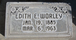
Edith Emoline Wright Worley
| Birth | : | 19 Jan 1885 Council Bluffs, Pottawattamie County, Iowa, USA |
| Death | : | 6 Mar 1963 Alliance, Box Butte County, Nebraska, USA |
| Burial | : | Maple Hill Cemetery, Stoutsville, Fairfield County, USA |
| Coordinate | : | 39.6006012, -82.8227997 |
| Plot | : | Block 8, Section 1, Lot 3, Space 6 |
| Description | : | OBITUARY ALLIANCE TIMES HERALD, MARCH 7, 1963 "Mrs. Ralph Worley, Resident of Alliance Since 1888, Dies Here" Mrs. Edith Emoline Worley 78, died Wednesday afternoon at her home, 424 Cheyenne. Mrs. Worley, who had lived in the Alliance area since 1888, had been in failing health the past several months. She was born January 19, 1885, in Pottawatomie County, IA. She went with her parents in 1888 to Hay Springs on the railroad and then came by covered wagon to the family homestead west of Alliance. The family lived in a dugout until their sod house was built.... Read More |
frequently asked questions (FAQ):
-
Where is Edith Emoline Wright Worley's memorial?
Edith Emoline Wright Worley's memorial is located at: Maple Hill Cemetery, Stoutsville, Fairfield County, USA.
-
When did Edith Emoline Wright Worley death?
Edith Emoline Wright Worley death on 6 Mar 1963 in Alliance, Box Butte County, Nebraska, USA
-
Where are the coordinates of the Edith Emoline Wright Worley's memorial?
Latitude: 39.6006012
Longitude: -82.8227997
Family Members:
Parent

Spouse
Siblings
Children
Flowers:


Nearby Cemetories:
1. Maple Hill Cemetery
Stoutsville, Fairfield County, USA
Coordinate: 39.6006012, -82.8227997
2. Heidelberg Reformed Church Cemetery
Stoutsville, Fairfield County, USA
Coordinate: 39.6047783, -82.8269348
3. Wolf Cemetery
Stoutsville, Fairfield County, USA
Coordinate: 39.5901600, -82.8070200
4. Bunker Hill Cemetery
Stoutsville, Fairfield County, USA
Coordinate: 39.5855100, -82.8308600
5. Neff Cemetery
Stoutsville, Fairfield County, USA
Coordinate: 39.5821991, -82.8106003
6. Stout Family Cemetery
Washington Township, Pickaway County, USA
Coordinate: 39.6241989, -82.8439026
7. Spengler Cemetery
Stoutsville, Fairfield County, USA
Coordinate: 39.5653290, -82.8241650
8. Zion Cemetery
Circleville, Pickaway County, USA
Coordinate: 39.6119003, -82.8688965
9. Saint Pauls Evangelical Church Cemetery
Pickaway County, USA
Coordinate: 39.5925600, -82.8718400
10. Infirmary Cemetery
Pickaway County, USA
Coordinate: 39.6183014, -82.8675003
11. Dresbach Cemetery
Stoutsville, Fairfield County, USA
Coordinate: 39.5608978, -82.8262863
12. Mace Cemetery
Amanda, Fairfield County, USA
Coordinate: 39.6474710, -82.7978680
13. Old Conrad Cemetery
Amanda, Fairfield County, USA
Coordinate: 39.6153720, -82.7594120
14. Old Dutch Hollow Cemetery
Amanda, Fairfield County, USA
Coordinate: 39.6466410, -82.7908450
15. Conrad Cemetery
Amanda, Fairfield County, USA
Coordinate: 39.6156006, -82.7568970
16. Dutch Hollow Cemetery
Amanda, Fairfield County, USA
Coordinate: 39.6478004, -82.7897034
17. Bethany Cemetery
Circleville, Pickaway County, USA
Coordinate: 39.6437700, -82.8643000
18. Pontius Chapel Cemetery
Pickaway County, USA
Coordinate: 39.6009000, -82.8932300
19. Tarlton United Brethren Cemetery
Stoutsville, Fairfield County, USA
Coordinate: 39.5576530, -82.7792140
20. Walter Leist Farm Cemetery
Circleville, Pickaway County, USA
Coordinate: 39.6384060, -82.8743330
21. John Graffis Farm Cemetery
Circleville, Pickaway County, USA
Coordinate: 39.6280070, -82.8891730
22. Tarlton Cemetery
Tarlton, Pickaway County, USA
Coordinate: 39.5550630, -82.7737820
23. Emanuel Mennonite Church Cemetery
Amanda, Fairfield County, USA
Coordinate: 39.6171580, -82.7471100
24. Zinser Cemetery
Circleville, Pickaway County, USA
Coordinate: 39.6513090, -82.8660930