
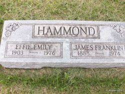
Effie Emily Adams Hammond
| Birth | : | 1 Jul 1903 Appanoose County, Iowa, USA |
| Death | : | 23 Jul 1976 Iowa, USA |
| Burial | : | Nativity of the Blessed Virgin Mary Churchyard, Ringstead, East Northamptonshire Borough, England |
| Coordinate | : | 52.3652660, -0.5533620 |
| Plot | : | Row 3 |
| Description | : | S/S as James Franklin |
frequently asked questions (FAQ):
-
Where is Effie Emily Adams Hammond's memorial?
Effie Emily Adams Hammond's memorial is located at: Nativity of the Blessed Virgin Mary Churchyard, Ringstead, East Northamptonshire Borough, England.
-
When did Effie Emily Adams Hammond death?
Effie Emily Adams Hammond death on 23 Jul 1976 in Iowa, USA
-
Where are the coordinates of the Effie Emily Adams Hammond's memorial?
Latitude: 52.3652660
Longitude: -0.5533620
Family Members:
Parent

Spouse

Siblings

Children
Flowers:


Nearby Cemetories:
1. Nativity of the Blessed Virgin Mary Churchyard
Ringstead, East Northamptonshire Borough, England
Coordinate: 52.3652660, -0.5533620
2. Station Street Cemetery
Ringstead, East Northamptonshire Borough, England
Coordinate: 52.3654427, -0.5538628
3. Station Road Cemetery
Ringsted Kommune, Denmark
Coordinate: 52.3638126, -0.5592430
4. Holy Trinity Church
Denford, East Northamptonshire Borough, England
Coordinate: 52.3787353, -0.5450568
5. Raunds Cemetery
Raunds, East Northamptonshire Borough, England
Coordinate: 52.3494100, -0.5467400
6. All Saints Churchyard
Great Addington, East Northamptonshire Borough, England
Coordinate: 52.3657660, -0.5937010
7. St. Laurence Churchyard Stanwick
Stanwick, East Northamptonshire Borough, England
Coordinate: 52.3324970, -0.5628585
8. St. Nicholas Churchyard
Islip, East Northamptonshire Borough, England
Coordinate: 52.3991300, -0.5513600
9. Stanwick Cemetery
Stanwick, East Northamptonshire Borough, England
Coordinate: 52.3298800, -0.5531500
10. Thrapston Cemetery
Thrapston, East Northamptonshire Borough, England
Coordinate: 52.4000170, -0.5292640
11. St. Nicholas' Churchyard
Twywell, East Northamptonshire Borough, England
Coordinate: 52.3936001, -0.6024166
12. St. Peter's Churchyard
Lowick, East Northamptonshire Borough, England
Coordinate: 52.4116300, -0.5570600
13. St Peter's Churchyard
Irthlingborough, East Northamptonshire Borough, England
Coordinate: 52.3251642, -0.6101925
14. St. Mary's Churchyard
Titchmarsh, East Northamptonshire Borough, England
Coordinate: 52.4076080, -0.4998860
15. St. John the Baptist Churchyard
Chelveston, East Northamptonshire Borough, England
Coordinate: 52.3112800, -0.5501200
16. St. John's Churchyard
Cranford St John, Kettering Borough, England
Coordinate: 52.3840560, -0.6391670
17. St. Andrew's Churchyard
Cranford, Kettering Borough, England
Coordinate: 52.3856700, -0.6438700
18. All Hallow's Church Hargrave Churchyard
Hargrave, East Northamptonshire Borough, England
Coordinate: 52.3242316, -0.4800580
19. All Saints Churchyard
Aldwincle, East Northamptonshire Borough, England
Coordinate: 52.4222080, -0.5142150
20. Higham Ferrers Cemetery
Higham Ferrers, East Northamptonshire Borough, England
Coordinate: 52.3084850, -0.5945270
21. St. Mary the Virgin Churchyard
Higham Ferrers, East Northamptonshire Borough, England
Coordinate: 52.3065500, -0.5915240
22. Aldwincle St Peters Churchyard
Aldwincle, East Northamptonshire Borough, England
Coordinate: 52.4255060, -0.5217460
23. All Saints Church
Sudborough, East Northamptonshire Borough, England
Coordinate: 52.4283980, -0.5782500
24. New Irthlingborough Cemetery
Irthlingborough, East Northamptonshire Borough, England
Coordinate: 52.3178531, -0.6294229