
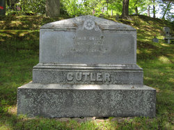
Elihu Cutler
| Birth | : | 25 May 1771 Holliston, Middlesex County, Massachusetts, USA |
| Death | : | 2 Jun 1857 Holliston, Middlesex County, Massachusetts, USA |
| Burial | : | St. Andrew's Churchyard, Cheddar, Sedgemoor District, England |
| Coordinate | : | 51.2736740, -2.7761330 |
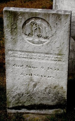
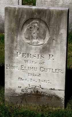
| Inscription | : | Hon. ELIHU CUTLER died June 2, 1857 aged 86 years. |
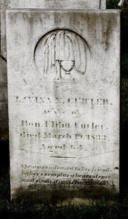
| Description | : | Holliston births: CUTLER, Elihu, s. Simeon and Elizabeth, May 25, 1771. [Hon. Elihu [h. Lavina N.] GR1] Holliston marriages: CUTLER, Elihu and Levina Newton, Nov. 25, 1798. [Elihue and Lavina Newton. CR1] Holliston deaths: CUTLER, Levina, w. Elihu, Mar. 19, 1833, a. 64. [w. Hon. Elihue. CR1] [Lavina N., w. Hon. Elihu. GR1] Holliston marriages: CUTLER, Elihu Esq., widr. [int. omits widr.], 73, justice, s. Elizabeth, wid., and Persis Plympton [int. omits Plympton] Phipps, 41, d. Dea. William and L., Dec. 4, 1844. |
frequently asked questions (FAQ):
-
Where is Elihu Cutler's memorial?
Elihu Cutler's memorial is located at: St. Andrew's Churchyard, Cheddar, Sedgemoor District, England.
-
When did Elihu Cutler death?
Elihu Cutler death on 2 Jun 1857 in Holliston, Middlesex County, Massachusetts, USA
-
Where are the coordinates of the Elihu Cutler's memorial?
Latitude: 51.2736740
Longitude: -2.7761330
Family Members:
Parent
Spouse
Siblings

Children
Flowers:


Nearby Cemetories:
1. St. Andrew's Churchyard
Cheddar, Sedgemoor District, England
Coordinate: 51.2736740, -2.7761330
2. Cheddar Baptist Burial Ground
Cheddar, Sedgemoor District, England
Coordinate: 51.2767330, -2.7792010
3. St. Peter's Churchyard
Draycott, Mendip District, England
Coordinate: 51.2580900, -2.7523800
4. St. Michael Sanatorium Cemetery
Axbridge, Sedgemoor District, England
Coordinate: 51.2904100, -2.8056900
5. St. John the Baptist Churchyard
Axbridge, Sedgemoor District, England
Coordinate: 51.2876300, -2.8162900
6. St. Leonard's Churchyard
Rodney Stoke, Mendip District, England
Coordinate: 51.2455140, -2.7431800
7. St Gregory Churchyard
Weare, Sedgemoor District, England
Coordinate: 51.2699900, -2.8408600
8. St Leonard's Churchyard
Shipham, Sedgemoor District, England
Coordinate: 51.3130980, -2.8001830
9. St. Mary Magdalene Churchyard Extension
Wedmore, Sedgemoor District, England
Coordinate: 51.2327583, -2.8065246
10. Shipham Cemetery
Shipham, Sedgemoor District, England
Coordinate: 51.3201930, -2.7992390
11. St. Mary Churchyard
Wedmore, Sedgemoor District, England
Coordinate: 51.2276790, -2.8110360
12. St Michael and All Angels
Rowberrow, North Somerset Unitary Authority, England
Coordinate: 51.3240000, -2.7915000
13. Allerton Churchyard
Chapel Allerton, Sedgemoor District, England
Coordinate: 51.2479860, -2.8482400
14. Baptist Churchyard
Wedmore, Sedgemoor District, England
Coordinate: 51.2260400, -2.8099800
15. St Lawrence Churchyard
Westbury, Mendip District, England
Coordinate: 51.2354140, -2.7182630
16. St. James the Great Churchyard
Winscombe, North Somerset Unitary Authority, England
Coordinate: 51.3059750, -2.8456900
17. St Congar Churchyard
Badgworth, Sedgemoor District, England
Coordinate: 51.2699300, -2.8674000
18. Holy Trinity Churchyard
Burrington, North Somerset Unitary Authority, England
Coordinate: 51.3307830, -2.7496010
19. Saint Andrew Churchyard
Compton Bishop, Sedgemoor District, England
Coordinate: 51.2943290, -2.8678900
20. Winscombe and Sandford Cemetery
Winscombe, North Somerset Unitary Authority, England
Coordinate: 51.3223861, -2.8386889
21. Methodist Church Burial Ground
Churchill, North Somerset Unitary Authority, England
Coordinate: 51.3344140, -2.8000610
22. Christ Church Theale
Wedmore, Sedgemoor District, England
Coordinate: 51.2113720, -2.7631570
23. St. Lawrence's Churchyard
Priddy, Mendip District, England
Coordinate: 51.2596770, -2.6777600
24. Holy Trinity Churchyard
Blackford, Sedgemoor District, England
Coordinate: 51.2257800, -2.8483000