
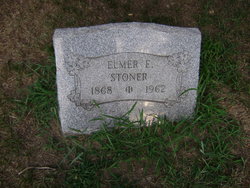
Elmer E Stoner
| Birth | : | 14 Aug 1868 Westmoreland County, Pennsylvania, USA |
| Death | : | 16 Jun 1962 Mount Pleasant, Westmoreland County, Pennsylvania, USA |
| Burial | : | St. Mary's Churchyard, Greasley, Broxtowe Borough, England |
| Coordinate | : | 53.0201100, -1.2720500 |
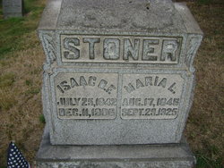
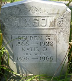
| Description | : | SCOTTDALE - Elmer E. Stoner, 93, of East Huntingdon Township near Scottdale, died at 5:30 a.m. today in Frick Community Hospital in Mount Pleasant. He was born Aug. 14, 1868, in East Huntingdon Twp., a son of the late Isaac and Maria Loucks Stoner. He was a carpenter in the area for many years. He was a member of Mt. Nebo EUB Church and past treasurer of the church. Surviving are two sisters, Mrs. Netta Yoder and Mrs. Katie Hixson of Scottdale. The body will be in the Murphy funeral home after 7 p.m. today where the funeral service will be held at 2... Read More |
frequently asked questions (FAQ):
-
Where is Elmer E Stoner's memorial?
Elmer E Stoner's memorial is located at: St. Mary's Churchyard, Greasley, Broxtowe Borough, England.
-
When did Elmer E Stoner death?
Elmer E Stoner death on 16 Jun 1962 in Mount Pleasant, Westmoreland County, Pennsylvania, USA
-
Where are the coordinates of the Elmer E Stoner's memorial?
Latitude: 53.0201100
Longitude: -1.2720500
Family Members:
Parent

Siblings
Flowers:


Nearby Cemetories:
1. St. Mary's Churchyard
Greasley, Broxtowe Borough, England
Coordinate: 53.0201100, -1.2720500
2. St. Mary's Churchyard
Eastwood, Broxtowe Borough, England
Coordinate: 53.0166227, -1.3084371
3. Eastwood Cemetery
Eastwood, Broxtowe Borough, England
Coordinate: 53.0115814, -1.3073300
4. St John's Church, Aldercar
Amber Valley Borough, England
Coordinate: 53.0266800, -1.3360000
5. St. Mary Magdalene Churchyard
Hucknall, Ashfield District, England
Coordinate: 53.0390630, -1.2058330
6. Northern Cemetery
Bulwell, Nottingham Unitary Authority, England
Coordinate: 52.9979840, -1.2077900
7. Hucknall Cemetery
Hucknall, Ashfield District, England
Coordinate: 53.0293427, -1.1988190
8. Marlpool Municipal Cemetery
Heanor, Amber Valley Borough, England
Coordinate: 53.0082110, -1.3490550
9. All Saints Churchyard
Annesley, Ashfield District, England
Coordinate: 53.0662300, -1.2501190
10. All Saints Church
Strelley, Broxtowe Borough, England
Coordinate: 52.9737900, -1.2470340
11. Park Cemetery
Ilkeston, Erewash Borough, England
Coordinate: 52.9714000, -1.3006350
12. Newstead Hucknall Road Cemetery
Newstead, Gedling Borough, England
Coordinate: 53.0651470, -1.2298350
13. St. Mary's Churchyard
Jacksdale, Ashfield District, England
Coordinate: 53.0577660, -1.3326300
14. St. Mary the Virgin Churchyard
Newstead, Gedling Borough, England
Coordinate: 53.0688200, -1.2273000
15. Ilkeston Stanton Road
Ilkeston, Erewash Borough, England
Coordinate: 52.9645800, -1.3077120
16. Annesley and Felley
Annesley, Ashfield District, England
Coordinate: 53.0771910, -1.2407140
17. Holy Trinity Churchyard
Mapperley, Amber Valley Borough, England
Coordinate: 52.9818800, -1.3536800
18. St. James Churchyard
Papplewick, Gedling Borough, England
Coordinate: 53.0582060, -1.1872990
19. Christ Church Churchyard
Ironville, Amber Valley Borough, England
Coordinate: 53.0628250, -1.3508600
20. Crosshill Cemetery
Codnor, Amber Valley Borough, England
Coordinate: 53.0329710, -1.3764590
21. St. James' Churchyard
Codnor, Amber Valley Borough, England
Coordinate: 53.0343350, -1.3772720
22. All Saints
Kirk Hallam, Erewash Borough, England
Coordinate: 52.9602950, -1.3188150
23. St. Helen's Churchyard
Trowell, Broxtowe Borough, England
Coordinate: 52.9528120, -1.2815590
24. St. Leodegarius Churchyard
Old Basford, Nottingham Unitary Authority, England
Coordinate: 52.9794240, -1.1778650