

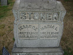
Maria Loucks Stoner
| Birth | : | 17 Aug 1846 Westmoreland County, Pennsylvania, USA |
| Death | : | 29 Sep 1925 Westmoreland County, Pennsylvania, USA |
| Burial | : | St. Mary's Churchyard, Greasley, Broxtowe Borough, England |
| Coordinate | : | 53.0201100, -1.2720500 |
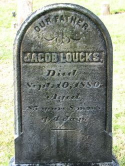
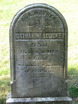
| Description | : | Pennsylvania, Death Certificates, 1906-1944 Name: Maria L Stoner [Maria L Loucks] Gender: Female Race: White Age: 79 Birth Date: 17 Aug 1846 Birth Place: E Huntingdon Twp, Pennsylvania Death Date: 29 Sep 1925 Death Place: East Huntingdon, Westmoreland, Pennsylvania, USA Father Name: Jacob Loucks Father Birth Place: Pennsylvania Mother Name: Katherine Smith Mother Birth Place: Pennsylvania Spouse Name: Isaac Stoner Certificate Number: 92699 (Information courtesy of F.A.G. member# 47347675) |
frequently asked questions (FAQ):
-
Where is Maria Loucks Stoner's memorial?
Maria Loucks Stoner's memorial is located at: St. Mary's Churchyard, Greasley, Broxtowe Borough, England.
-
When did Maria Loucks Stoner death?
Maria Loucks Stoner death on 29 Sep 1925 in Westmoreland County, Pennsylvania, USA
-
Where are the coordinates of the Maria Loucks Stoner's memorial?
Latitude: 53.0201100
Longitude: -1.2720500
Family Members:
Parent
Spouse
Siblings

Children
Flowers:


Nearby Cemetories:
1. St. Mary's Churchyard
Greasley, Broxtowe Borough, England
Coordinate: 53.0201100, -1.2720500
2. St. Mary's Churchyard
Eastwood, Broxtowe Borough, England
Coordinate: 53.0166227, -1.3084371
3. Eastwood Cemetery
Eastwood, Broxtowe Borough, England
Coordinate: 53.0115814, -1.3073300
4. St John's Church, Aldercar
Amber Valley Borough, England
Coordinate: 53.0266800, -1.3360000
5. St. Mary Magdalene Churchyard
Hucknall, Ashfield District, England
Coordinate: 53.0390630, -1.2058330
6. Northern Cemetery
Bulwell, Nottingham Unitary Authority, England
Coordinate: 52.9979840, -1.2077900
7. Hucknall Cemetery
Hucknall, Ashfield District, England
Coordinate: 53.0293427, -1.1988190
8. Marlpool Municipal Cemetery
Heanor, Amber Valley Borough, England
Coordinate: 53.0082110, -1.3490550
9. All Saints Churchyard
Annesley, Ashfield District, England
Coordinate: 53.0662300, -1.2501190
10. All Saints Church
Strelley, Broxtowe Borough, England
Coordinate: 52.9737900, -1.2470340
11. Park Cemetery
Ilkeston, Erewash Borough, England
Coordinate: 52.9714000, -1.3006350
12. Newstead Hucknall Road Cemetery
Newstead, Gedling Borough, England
Coordinate: 53.0651470, -1.2298350
13. St. Mary's Churchyard
Jacksdale, Ashfield District, England
Coordinate: 53.0577660, -1.3326300
14. St. Mary the Virgin Churchyard
Newstead, Gedling Borough, England
Coordinate: 53.0688200, -1.2273000
15. Ilkeston Stanton Road
Ilkeston, Erewash Borough, England
Coordinate: 52.9645800, -1.3077120
16. Annesley and Felley
Annesley, Ashfield District, England
Coordinate: 53.0771910, -1.2407140
17. Holy Trinity Churchyard
Mapperley, Amber Valley Borough, England
Coordinate: 52.9818800, -1.3536800
18. St. James Churchyard
Papplewick, Gedling Borough, England
Coordinate: 53.0582060, -1.1872990
19. Christ Church Churchyard
Ironville, Amber Valley Borough, England
Coordinate: 53.0628250, -1.3508600
20. Crosshill Cemetery
Codnor, Amber Valley Borough, England
Coordinate: 53.0329710, -1.3764590
21. St. James' Churchyard
Codnor, Amber Valley Borough, England
Coordinate: 53.0343350, -1.3772720
22. All Saints
Kirk Hallam, Erewash Borough, England
Coordinate: 52.9602950, -1.3188150
23. St. Helen's Churchyard
Trowell, Broxtowe Borough, England
Coordinate: 52.9528120, -1.2815590
24. St. Leodegarius Churchyard
Old Basford, Nottingham Unitary Authority, England
Coordinate: 52.9794240, -1.1778650