
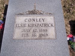
Elsie Kirkpatrick Conley
| Birth | : | 12 Jul 1888 Kingsley, Plymouth County, Iowa, USA |
| Death | : | 16 Feb 1969 Sioux City, Woodbury County, Iowa, USA |
| Burial | : | St Mary the Virgin Churchyard, South Milford, Selby District, England |
| Coordinate | : | 53.7771700, -1.2547300 |
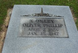
| Description | : | Tuesday, February 18, 1969 Le Mars Daily Sentinel Le Mars, Iowa Mrs. Oliver Conley, 80, Sioux City, died Sunday at a Sioux City hospital after a long illness. Funeral services will be at 2 p.m. Wednesday in the Federated church at Washta. Burial will be in Sunset View cemetery, under the direction of Anderson funeral home, Sioux City. She was born July 12, 1888, near Kingsley. She moved to Washta at the age of 6 months. After graduating from high school there, she taught term school near Wagner. S.D. The former Elsie Kirkpatrick, she married Mr. Conley Feb. 17, 1906, at Battle Creek. They farmed near Washta until 1944 when they moved to Sioux City. Mr. Conley died in January, 1947,... Read More |
frequently asked questions (FAQ):
-
Where is Elsie Kirkpatrick Conley's memorial?
Elsie Kirkpatrick Conley's memorial is located at: St Mary the Virgin Churchyard, South Milford, Selby District, England.
-
When did Elsie Kirkpatrick Conley death?
Elsie Kirkpatrick Conley death on 16 Feb 1969 in Sioux City, Woodbury County, Iowa, USA
-
Where are the coordinates of the Elsie Kirkpatrick Conley's memorial?
Latitude: 53.7771700
Longitude: -1.2547300
Family Members:
Parent
Spouse
Siblings
Flowers:


Nearby Cemetories:
1. St Mary the Virgin Churchyard
South Milford, Selby District, England
Coordinate: 53.7771700, -1.2547300
2. All Saints Churchyard
Sherburn-in-Elmet, Selby District, England
Coordinate: 53.7956000, -1.2605740
3. St Wilfrid’s Churchyard
Monk Fryston, Selby District, England
Coordinate: 53.7618300, -1.2349700
4. Monk Fryston Cemetery
Monk Fryston, Selby District, England
Coordinate: 53.7604400, -1.2291700
5. All Saints Churchyard
Ledsham, Metropolitan Borough of Leeds, England
Coordinate: 53.7622160, -1.3091920
6. St James Churchyard
Fairburn, Selby District, England
Coordinate: 53.7426700, -1.2841000
7. Holy Trinity Churchyard
Barkston Ash, Selby District, England
Coordinate: 53.8189530, -1.2547620
8. St. Mary the Virgin Churchyard
Micklefield, Metropolitan Borough of Leeds, England
Coordinate: 53.7971300, -1.3313700
9. Brotherton United Reformed Church
Brotherton, Selby District, England
Coordinate: 53.7277104, -1.2698131
10. All Saints Churchyard
Saxton, Selby District, England
Coordinate: 53.8261760, -1.2787060
11. St Mary the Virgin Churchyard
Church Fenton, Selby District, England
Coordinate: 53.8243100, -1.2203500
12. St Edward the Confessor Churchyard
Brotherton, Selby District, England
Coordinate: 53.7259200, -1.2709600
13. Hambleton Cemetery
Hambleton, Selby District, England
Coordinate: 53.7715910, -1.1624600
14. St Mary Churchyard
Hambleton, Selby District, England
Coordinate: 53.7715910, -1.1624600
15. St. Peter's Churchyard
Fryston, Metropolitan Borough of Wakefield, England
Coordinate: 53.7355400, -1.3151100
16. St Mary Churchyard
Birkin, Selby District, England
Coordinate: 53.7325000, -1.1979000
17. Lotherton Hall Chapel
Leeds, Metropolitan Borough of Leeds, England
Coordinate: 53.8186380, -1.3189740
18. St. Andrew's Old Churchyard
Ferrybridge, Metropolitan Borough of Wakefield, England
Coordinate: 53.7193380, -1.2748540
19. St. Botolph Churchyard
Knottingley, Metropolitan Borough of Wakefield, England
Coordinate: 53.7108080, -1.2441680
20. United Reformed Churchyard
Knottingley, Metropolitan Borough of Wakefield, England
Coordinate: 53.7104820, -1.2397270
21. St Mary the Virgin Churchyard
Kippax, Metropolitan Borough of Leeds, England
Coordinate: 53.7676520, -1.3686680
22. Ropewalk Methodist Church Burial Ground
Knottingley, Metropolitan Borough of Wakefield, England
Coordinate: 53.7092850, -1.2408320
23. Ferrybridge Cemetery
Ferrybridge, Metropolitan Borough of Wakefield, England
Coordinate: 53.7102530, -1.2795200
24. Castleford New Extension Cemetery
Castleford, Metropolitan Borough of Wakefield, England
Coordinate: 53.7277600, -1.3391000