
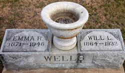
Emma Roda Teasley Wells
| Birth | : | 23 Oct 1871 Ottawa County, Kansas, USA |
| Death | : | 30 Nov 1946 Beloit, Mitchell County, Kansas, USA |
| Burial | : | Glasco Cemetery, Glasco, Cloud County, USA |
| Coordinate | : | 39.3574000, -97.8265000 |
| Plot | : | 1GE2 |
| Description | : | Links to parents sent by Rainbow, 47002487, who also sent her place of birth. ******************* Glasco Sun, Dec. 5, 1946, page 5: Mrs. Emma Wells, daughter of Mr. and Mrs. W.W. Teasley, was born Oct. 23, 1871, near Ottawa, Kans. and passed away at the home of her aunt, Mrs. Fannie Duffy, Beloit, Kans., Nov. 30, 1946. She was the oldest of a family of eight children, all reared on the homestead five miles north of Glasco. Of this pioneer family, the father and mother and five brothers and sisters have preceded her in death. On Feb.... Read More |
frequently asked questions (FAQ):
-
Where is Emma Roda Teasley Wells's memorial?
Emma Roda Teasley Wells's memorial is located at: Glasco Cemetery, Glasco, Cloud County, USA.
-
When did Emma Roda Teasley Wells death?
Emma Roda Teasley Wells death on 30 Nov 1946 in Beloit, Mitchell County, Kansas, USA
-
Where are the coordinates of the Emma Roda Teasley Wells's memorial?
Latitude: 39.3574000
Longitude: -97.8265000
Family Members:
Parent

Spouse

Siblings

Flowers:


Nearby Cemetories:
1. Glasco Cemetery
Glasco, Cloud County, USA
Coordinate: 39.3574000, -97.8265000
2. Saint Marys Catholic Cemetery
Glasco, Cloud County, USA
Coordinate: 39.3574000, -97.8245000
3. Simpson Cemetery
Simpson, Mitchell County, USA
Coordinate: 39.3633003, -97.9471970
4. Bethel Cemetery
Meredith Township, Cloud County, USA
Coordinate: 39.3506000, -97.7029000
5. Delphos Cemetery
Delphos, Ottawa County, USA
Coordinate: 39.2778015, -97.7416992
6. Saint Paul Cemetery
Delphos, Ottawa County, USA
Coordinate: 39.2677994, -97.7518997
7. Asherville Cemetery
Asherville, Mitchell County, USA
Coordinate: 39.4205000, -97.9672900
8. Morrison Cemetery
Center Township, Cloud County, USA
Coordinate: 39.4817009, -97.7975006
9. Summit Cemetery
Jamestown, Cloud County, USA
Coordinate: 39.4813200, -97.8628800
10. Green Mound Cemetery
Asherville, Mitchell County, USA
Coordinate: 39.3203011, -97.9858017
11. Coursen Grove Cemetery
Simpson, Mitchell County, USA
Coordinate: 39.3060989, -97.9792023
12. Hall Cemetery
Cloud County, USA
Coordinate: 39.4455986, -97.7033005
13. Saint Peters Cemetery
Miltonvale, Cloud County, USA
Coordinate: 39.3652350, -97.6483570
14. Bell-Bogardus Cemetery
Asherville, Mitchell County, USA
Coordinate: 39.4242410, -97.9919970
15. Bohemian National Cemetery
Ada, Ottawa County, USA
Coordinate: 39.2193870, -97.9054030
16. Wilcox Cemetery
Cloud County, USA
Coordinate: 39.4925003, -97.7313995
17. West Asher Cemetery
Scottsville, Mitchell County, USA
Coordinate: 39.4815000, -97.9661600
18. Baldwin Cemetery
Ottawa County, USA
Coordinate: 39.2061005, -97.9111023
19. Kindel Cemetery
Center Township, Cloud County, USA
Coordinate: 39.4519005, -97.6464005
20. Smith Cemetery
Asherville, Mitchell County, USA
Coordinate: 39.4516690, -98.0098850
21. McBride Cemetery
Beloit, Mitchell County, USA
Coordinate: 39.4808006, -97.9907990
22. Enterprise Cemetery
Cloud County, USA
Coordinate: 39.4230995, -97.6106033
23. Shiloh Cemetery
Beloit, Mitchell County, USA
Coordinate: 39.3574982, -98.0594025
24. Summit Cemetery #3
Macyville, Cloud County, USA
Coordinate: 39.5258330, -97.9194440