
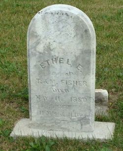
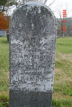
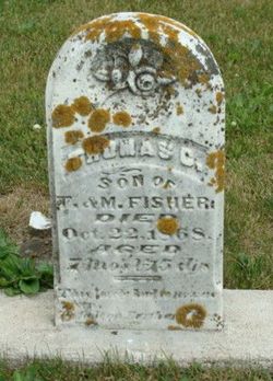
Ethel Esther Fisher
| Birth | : | 31 May 1879 Lodomillo Township, Clayton County, Iowa, USA |
| Death | : | 11 May 1880 Lodomillo Township, Clayton County, Iowa, USA |
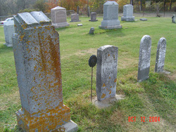
| Burial | : | Bloomfield Cemetery, Bloomfield, Sonoma County, USA |
| Coordinate | : | 38.3135986, -122.8583984 |
| Description | : | Dau. of Thomas Fisher & Margaret Jones. |
frequently asked questions (FAQ):
-
Where is Ethel Esther Fisher's memorial?
Ethel Esther Fisher's memorial is located at: Bloomfield Cemetery, Bloomfield, Sonoma County, USA.
-
When did Ethel Esther Fisher death?
Ethel Esther Fisher death on 11 May 1880 in Lodomillo Township, Clayton County, Iowa, USA
-
Where are the coordinates of the Ethel Esther Fisher's memorial?
Latitude: 38.3135986
Longitude: -122.8583984
Family Members:
Parent
Siblings

Flowers:


Nearby Cemetories:
1. Bloomfield Cemetery
Bloomfield, Sonoma County, USA
Coordinate: 38.3135986, -122.8583984
2. Canfield Cemetery
Sebastopol, Sonoma County, USA
Coordinate: 38.3512430, -122.8147040
3. Pleasant Hills Memorial Park and Mortuary
Sebastopol, Sonoma County, USA
Coordinate: 38.3792000, -122.8350983
4. Jasper O'Farrell Ranch Cemetery
Freestone, Sonoma County, USA
Coordinate: 38.3758300, -122.9090300
5. Tomales Presbyterian Cemetery
Tomales, Marin County, USA
Coordinate: 38.2455215, -122.9075089
6. Tomales Catholic Cemetery
Tomales, Marin County, USA
Coordinate: 38.2482300, -122.9142500
7. Macedonia Methodist Episcopal Church Cemetery
Sebastopol, Sonoma County, USA
Coordinate: 38.3594860, -122.7727270
8. Spring Hill Cemetery
Sebastopol, Sonoma County, USA
Coordinate: 38.3968010, -122.8637009
9. Two Rock Presbyterian Church Cemetery
Two Rock, Sonoma County, USA
Coordinate: 38.2570000, -122.7795029
10. Sebastopol Memorial Lawn Cemetery
Sebastopol, Sonoma County, USA
Coordinate: 38.3981018, -122.8366013
11. Saint Theresa of Avila Church Cemetery
Bodega, Sonoma County, USA
Coordinate: 38.3461342, -122.9723663
12. Calvary Cemetery
Bodega, Sonoma County, USA
Coordinate: 38.3414993, -122.9749985
13. Druids Occidental Cemetery
Occidental, Sonoma County, USA
Coordinate: 38.4104996, -122.9419022
14. Gilliam Cemetery
Graton, Sonoma County, USA
Coordinate: 38.4314995, -122.8816986
15. Liberty Cemetery
Petaluma, Sonoma County, USA
Coordinate: 38.2781990, -122.7055500
16. Green Valley Cemetery
Sebastopol, Sonoma County, USA
Coordinate: 38.4424019, -122.8869019
17. Bodega Bay Cemetery
Bodega Bay, Sonoma County, USA
Coordinate: 38.3172740, -123.0257990
18. Steele Family Cemetery
Santa Rosa, Sonoma County, USA
Coordinate: 38.4523730, -122.8065610
19. Chapel of the Chimes Cemetery and Mausoleum
Santa Rosa, Sonoma County, USA
Coordinate: 38.4141998, -122.7137985
20. Forestview Cemetery
Forestville, Sonoma County, USA
Coordinate: 38.4677010, -122.8834000
21. Miwok Cemetery
Reynolds, Marin County, USA
Coordinate: 38.1491420, -122.8852400
22. Luther Burbank Memorial Home and Gardens Cemetery
Santa Rosa, Sonoma County, USA
Coordinate: 38.4355810, -122.7118050
23. My Pets Cemetery
Petaluma, Sonoma County, USA
Coordinate: 38.2472000, -122.6506000
24. Cypress Hill Memorial Park
Petaluma, Sonoma County, USA
Coordinate: 38.2472000, -122.6505966