
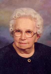
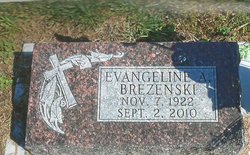
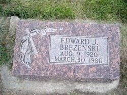
Evangeline A. Staroscik Brezenski
| Birth | : | 7 Nov 1922 Barnesville, Clay County, Minnesota, USA |
| Death | : | 2 Sep 2010 Columbus, Platte County, Nebraska, USA |
| Burial | : | St. Leonard's Churchyard, Rodney Stoke, Mendip District, England |
| Coordinate | : | 51.2455140, -2.7431800 |
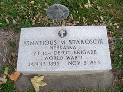
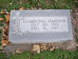
| Description | : | Evangeline died Thursday, September 2, 2010 at Morys Haven in Columbus. Evangeline A. Brezenski was born November 7, 1922 in Barnesville, Minnesota to Ignatius and Clementena (Nosal) Staroscik. She attended grade school in Polk, County and high school in Columbus. On August 9, 1943 Evangeline was united in marriage to Edward Brezenski at St. Stanislaus Church in Duncan. She worked for Becton-Dickinson for over 17 years until retiring in 1985. Evangeline was a member of St. Isidore Church, Christian Mothers and B.D. Retirement. She enjoyed bowling and baking (especially rice krispie treats for her grandchildren). She is survived by: Son: Bernard (Paulette) Brezenski... Read More |
frequently asked questions (FAQ):
-
Where is Evangeline A. Staroscik Brezenski's memorial?
Evangeline A. Staroscik Brezenski's memorial is located at: St. Leonard's Churchyard, Rodney Stoke, Mendip District, England.
-
When did Evangeline A. Staroscik Brezenski death?
Evangeline A. Staroscik Brezenski death on 2 Sep 2010 in Columbus, Platte County, Nebraska, USA
-
Where are the coordinates of the Evangeline A. Staroscik Brezenski's memorial?
Latitude: 51.2455140
Longitude: -2.7431800
Family Members:
Parent
Spouse
Siblings
Children

Flowers:


Nearby Cemetories:
1. St. Leonard's Churchyard
Rodney Stoke, Mendip District, England
Coordinate: 51.2455140, -2.7431800
2. St. Peter's Churchyard
Draycott, Mendip District, England
Coordinate: 51.2580900, -2.7523800
3. St Lawrence Churchyard
Westbury, Mendip District, England
Coordinate: 51.2354140, -2.7182630
4. St. Andrew's Churchyard
Cheddar, Sedgemoor District, England
Coordinate: 51.2736740, -2.7761330
5. Christ Church Theale
Wedmore, Sedgemoor District, England
Coordinate: 51.2113720, -2.7631570
6. Cheddar Baptist Burial Ground
Cheddar, Sedgemoor District, England
Coordinate: 51.2767330, -2.7792010
7. Christ Church Churchyard
Henton, Mendip District, England
Coordinate: 51.2056460, -2.7256380
8. St. Mary Magdalene Churchyard Extension
Wedmore, Sedgemoor District, England
Coordinate: 51.2327583, -2.8065246
9. St. Lawrence's Churchyard
Priddy, Mendip District, England
Coordinate: 51.2596770, -2.6777600
10. St. Mary Churchyard
Wedmore, Sedgemoor District, England
Coordinate: 51.2276790, -2.8110360
11. Baptist Churchyard
Wedmore, Sedgemoor District, England
Coordinate: 51.2260400, -2.8099800
12. St. Matthew Churchyard
Wookey, Mendip District, England
Coordinate: 51.2093000, -2.6893000
13. St. Michael Sanatorium Cemetery
Axbridge, Sedgemoor District, England
Coordinate: 51.2904100, -2.8056900
14. Wells Cemetery
Wells, Mendip District, England
Coordinate: 51.2088240, -2.6640120
15. St. John the Baptist Churchyard
Axbridge, Sedgemoor District, England
Coordinate: 51.2876300, -2.8162900
16. Allerton Churchyard
Chapel Allerton, Sedgemoor District, England
Coordinate: 51.2479860, -2.8482400
17. St Gregory Churchyard
Weare, Sedgemoor District, England
Coordinate: 51.2699900, -2.8408600
18. Holy Trinity Church
Godney, Mendip District, England
Coordinate: 51.1793400, -2.7377400
19. Holy Trinity Churchyard
Blackford, Sedgemoor District, England
Coordinate: 51.2257800, -2.8483000
20. St. Cuthbert Churchyard
Wells, Mendip District, England
Coordinate: 51.2080930, -2.6502690
21. Coxley Methodist Churchyard
Coxley, Mendip District, England
Coordinate: 51.1918900, -2.6723700
22. Christ Church
Coxley, Mendip District, England
Coordinate: 51.1869530, -2.6797580
23. Wells Cathedral
Wells, Mendip District, England
Coordinate: 51.2103610, -2.6433940
24. St Thomas Churchyard
Wells, Mendip District, England
Coordinate: 51.2132380, -2.6370870