
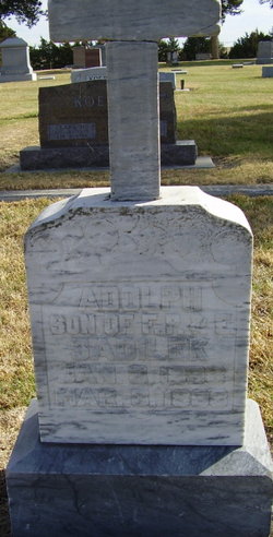
Frank P. Sadilek
| Birth | : | 17 Dec 1873 |
| Death | : | 7 Feb 1928 Blue Hill, Webster County, Nebraska, USA |
| Burial | : | St. Mary the Virgin Churchyard, Wappenham, South Northamptonshire Borough, England |
| Coordinate | : | 52.1057700, -1.0890570 |
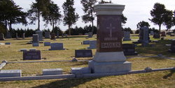
| Plot | : | SW section Lot 42 |
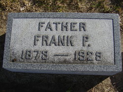
| Inscription | : | Father Frank P. SADILEK 1873 - 1928 |
| Description | : | ("Blue Hill Leader" newspaper dated Feb 10, 1928 page 1) Funeral Services for Frank Sadilek to be Held Friday The death of Frank Sadilek casts a shadow of sorrow over the community this week. He has been a long, patient sufferer with cancer and death relieved him from his suffering Tuesday afternoon at 5 o'clock. He was taken to Omaha several weeks ago where he underwent an operation for the dreaded disease. His desire to spend his last days at home were granted and he was brought home a week ago. Mr. Sadilek was considered one of the best farmers... Read More |
frequently asked questions (FAQ):
-
Where is Frank P. Sadilek's memorial?
Frank P. Sadilek's memorial is located at: St. Mary the Virgin Churchyard, Wappenham, South Northamptonshire Borough, England.
-
When did Frank P. Sadilek death?
Frank P. Sadilek death on 7 Feb 1928 in Blue Hill, Webster County, Nebraska, USA
-
Where are the coordinates of the Frank P. Sadilek's memorial?
Latitude: 52.1057700
Longitude: -1.0890570
Family Members:
Parent
Spouse
Children
Flowers:


Nearby Cemetories:
1. St. Mary the Virgin Churchyard
Wappenham, South Northamptonshire Borough, England
Coordinate: 52.1057700, -1.0890570
2. St. Botolph's Churchyard
Slapton, South Northamptonshire Borough, England
Coordinate: 52.1166000, -1.0666000
3. St. John the Baptist Churchyard
Abthorpe, South Northamptonshire Borough, England
Coordinate: 52.1131262, -1.0529425
4. St Mary and St Peter Churchyard
Weedon Lois, South Northamptonshire Borough, England
Coordinate: 52.1178320, -1.1228690
5. St. Mary Magdalene's Churchyard
Helmdon, South Northamptonshire Borough, England
Coordinate: 52.0838310, -1.1404000
6. St Mary Churchyard
Blakesley, South Northamptonshire Borough, England
Coordinate: 52.1489310, -1.0850410
7. St. Mary's Churchyard
Blakesley, South Northamptonshire Borough, England
Coordinate: 52.1490000, -1.0850000
8. Biddlesden Abbey
Harringworth, East Northamptonshire Borough, England
Coordinate: 52.0539000, -1.0797000
9. St. Margaret's Churchyard
Biddlesden, Aylesbury Vale District, England
Coordinate: 52.0535450, -1.0782870
10. Church of St. Mary The Virgin
Moreton Pinkney, South Northamptonshire Borough, England
Coordinate: 52.1369170, -1.1628810
11. St Bartholomew Churchyard
Greens Norton, South Northamptonshire Borough, England
Coordinate: 52.1434200, -1.0234100
12. All Saints Churchyard
Adstone, South Northamptonshire Borough, England
Coordinate: 52.1574740, -1.1306620
13. Brackley Road Cemetery
Towcester, South Northamptonshire Borough, England
Coordinate: 52.1294010, -0.9997560
14. St. Mary’s Churchyard
Canons Ashby, Daventry District, England
Coordinate: 52.1502747, -1.1568058
15. Canons Ashby
Daventry District, England
Coordinate: 52.1504600, -1.1566400
16. St. James the Less Churchyard
Sulgrave, South Northamptonshire Borough, England
Coordinate: 52.1036130, -1.1883880
17. St. Peter's Churchyard
Greatworth, South Northamptonshire Borough, England
Coordinate: 52.0770540, -1.1954490
18. St. Mary's Churchyard
Turweston, Aylesbury Vale District, England
Coordinate: 52.0345400, -1.1257500
19. Halse Road Cemetery
Brackley, South Northamptonshire Borough, England
Coordinate: 52.0395310, -1.1494450
20. St. Mary's Churchyard
Easton Neston, South Northamptonshire Borough, England
Coordinate: 52.1363720, -0.9756590
21. St. Luke's Churchyard
Cold Higham, South Northamptonshire Borough, England
Coordinate: 52.1759000, -1.0323000
22. St. Peter's Churchyard
Brackley, South Northamptonshire Borough, England
Coordinate: 52.0309710, -1.1390480
23. St James the Great Churchyard
Paulerspury, South Northamptonshire Borough, England
Coordinate: 52.1032000, -0.9565000
24. St. John the Baptist Churchyard
Thorpe Mandeville, South Northamptonshire Borough, England
Coordinate: 52.1003400, -1.2244400