

Frederick Alfred “Fred” Hurst
| Birth | : | 1877 |
| Death | : | 1945 |
| Burial | : | Herne Bay Cemetery, Herne Bay, City of Canterbury, England |
| Coordinate | : | 51.3571810, 1.1304820 |
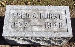
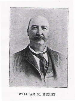
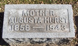
| Description | : | Frederick Alfred Hurst, son of William Kendall Hurst and Augusta Keil (Kuehl) Hurst, was born in Maquoketa, Iowa Dec. 7, 1877. He spent most of his life in Hurstville, Iowa. For more than 30 years he operated a general store at Hurstville and for the last 7 years of his life operated the Rockdale quarry north of Maquoketa. He was married in Maquoketa on Oct 10, 1900 to Miss Gertrude Alden. To them were born two children, William Alden Hurst, and Hazel Augusta. Fred died in 1945 after an extended illness. He is buried at Mt. Hope Cemetery. |
frequently asked questions (FAQ):
-
Where is Frederick Alfred “Fred” Hurst's memorial?
Frederick Alfred “Fred” Hurst's memorial is located at: Herne Bay Cemetery, Herne Bay, City of Canterbury, England.
-
When did Frederick Alfred “Fred” Hurst death?
Frederick Alfred “Fred” Hurst death on 1945 in
-
Where are the coordinates of the Frederick Alfred “Fred” Hurst's memorial?
Latitude: 51.3571810
Longitude: 1.1304820
Family Members:
Parent
Spouse
Siblings

Children
Flowers:


Nearby Cemetories:
1. Herne Bay Cemetery
Herne Bay, City of Canterbury, England
Coordinate: 51.3571810, 1.1304820
2. St Martins
Herne, City of Canterbury, England
Coordinate: 51.3500600, 1.1333200
3. St Martin's Churchyard
Herne, City of Canterbury, England
Coordinate: 51.3497060, 1.1334370
4. St Mary the Virgin Churchyard
Reculver, City of Canterbury, England
Coordinate: 51.3684750, 1.1766050
5. St John the Baptist Churchyard
Swalecliffe, City of Canterbury, England
Coordinate: 51.3645500, 1.0667200
6. St Mary The Virgin Churchyard
Chislet, City of Canterbury, England
Coordinate: 51.3343610, 1.1921020
7. St Mary's Abbey
Reculver, City of Canterbury, England
Coordinate: 51.3795360, 1.1993770
8. All Saints Churchyard
Westbere, City of Canterbury, England
Coordinate: 51.3065380, 1.1437670
9. Sturry Cemetery
Sturry, City of Canterbury, England
Coordinate: 51.3058100, 1.1277700
10. All Saints Churchyard
Whitstable, City of Canterbury, England
Coordinate: 51.3558090, 1.0396670
11. St Nicholas Churchyard
Sturry, City of Canterbury, England
Coordinate: 51.2984830, 1.1201330
12. Whitstable Cemetery
Whitstable, City of Canterbury, England
Coordinate: 51.3529870, 1.0338530
13. St Mary the Virgin Churchyard
Fordwich, City of Canterbury, England
Coordinate: 51.2958300, 1.1270530
14. Stodmarsh St Marys Churchyard
Wickhambreaux, City of Canterbury, England
Coordinate: 51.3009500, 1.1836900
15. St Alphege Churchyard
Whitstable, City of Canterbury, England
Coordinate: 51.3576330, 1.0251080
16. St Cosmus and St Damian Churchyard
Blean, City of Canterbury, England
Coordinate: 51.3052720, 1.0530480
17. St. Nicholas' Churchyard
St Nicholas at Wade, Thanet District, England
Coordinate: 51.3542160, 1.2517980
18. All Saints Churchyard
Stourmouth, Dover District, England
Coordinate: 51.3202600, 1.2365520
19. St Nicholas-at-Wade Cemetery
St Nicholas at Wade, Thanet District, England
Coordinate: 51.3578344, 1.2534168
20. St Gregory's Priory (defunct)
Canterbury, City of Canterbury, England
Coordinate: 51.2831127, 1.0855358
21. St. John the Baptist Hospital Chapelyard
Canterbury, City of Canterbury, England
Coordinate: 51.2832713, 1.0837677
22. St Andrew Churchyard
Wickhambreaux, City of Canterbury, England
Coordinate: 51.2844400, 1.1822300
23. St Gregory Churchyard
Canterbury, City of Canterbury, England
Coordinate: 51.2816050, 1.0887840
24. St Mildred Churchyard
Preston, Dover District, England
Coordinate: 51.2985000, 1.2173980