
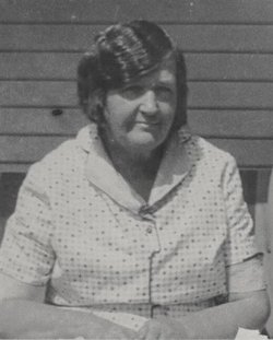
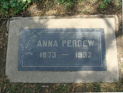
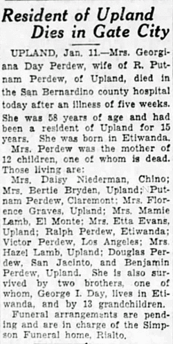
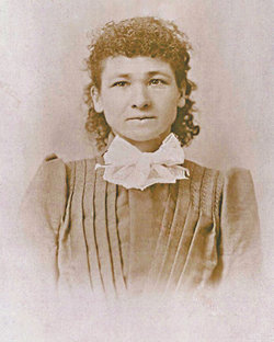
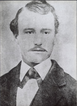
Georgianna “Anna” Day Perdew
| Birth | : | 16 May 1873 Etiwanda, San Bernardino County, California, USA |
| Death | : | 11 Jan 1932 San Bernardino County, California, USA |
| Burial | : | St Johns Churchyard, Hororata, Selwyn District, New Zealand |
| Coordinate | : | -43.5189100, 171.9457550 |
| Plot | : | Bl. 2, Lot 33, Grave 3N (N1/2), Family Plot #3 |
| Description | : | Georgianna's parents were George Isaac Day, who was b. in England and d. Mar. 20, 1875 & Martha Cassinda Wright, b. Mar., 1852 in TX. and d. Dec. 17, 1920 in Artesia, L.A., CA. Martha married Frank Shrode after George Day died). On Jan. 21, 1880 in San Bernardino Co., CA., Rufus Putnam Perdew married Georgianna's sister, Sarah Elizabeth Day who was b. in 1869. Rufus married Sarah when he was 25 and she was 11. (Her mother gave consent, her father being dead.) Put and Sarah Elizabeth (Day) Perdew had three children; 1) Grace... Read More |
frequently asked questions (FAQ):
-
Where is Georgianna “Anna” Day Perdew's memorial?
Georgianna “Anna” Day Perdew's memorial is located at: St Johns Churchyard, Hororata, Selwyn District, New Zealand.
-
When did Georgianna “Anna” Day Perdew death?
Georgianna “Anna” Day Perdew death on 11 Jan 1932 in San Bernardino County, California, USA
-
Where are the coordinates of the Georgianna “Anna” Day Perdew's memorial?
Latitude: -43.5189100
Longitude: 171.9457550
Family Members:
Parent
Spouse
Siblings

Children
Flowers:


Nearby Cemetories:
1. St Johns Churchyard
Hororata, Selwyn District, New Zealand
Coordinate: -43.5189100, 171.9457550
2. Hororata Cemetery
Hororata, Selwyn District, New Zealand
Coordinate: -43.5196600, 171.9461100
3. South Malvern Cemetery
Glentunnel, Selwyn District, New Zealand
Coordinate: -43.4807300, 171.9475200
4. Glenroy War Memorial
Glenroy, Selwyn District, New Zealand
Coordinate: -43.5199750, 171.8345040
5. Greendale Cemetery
Greendale, Selwyn District, New Zealand
Coordinate: -43.5447560, 172.0772460
6. Trinity Church Columbarium
Darfield, Selwyn District, New Zealand
Coordinate: -43.4888350, 172.1052750
7. St Joseph's Catholic Cemetery
Darfield, Selwyn District, New Zealand
Coordinate: -43.4918030, 172.1081060
8. Rockwood Station Cemetery
Windwhistle, Selwyn District, New Zealand
Coordinate: -43.4928406, 171.7730184
9. Waddington Cemetery
Waddington, Selwyn District, New Zealand
Coordinate: -43.4001830, 172.0424870
10. Kimberley Cemetery
Darfield, Selwyn District, New Zealand
Coordinate: -43.4485800, 172.1208100
11. Barrhill Cemetery
Barrhill, Ashburton District, New Zealand
Coordinate: -43.6756950, 171.8480790
12. Kowai Pass Cemetery
Springfield, Selwyn District, New Zealand
Coordinate: -43.3399830, 171.9334560
13. Highbank Cemetery
Highbank, Ashburton District, New Zealand
Coordinate: -43.6228060, 171.7387780
14. Kirwee Cemetery
Kirwee, Selwyn District, New Zealand
Coordinate: -43.4935800, 172.2118100
15. St George's Anglican Churchyard
Kirwee, Selwyn District, New Zealand
Coordinate: -43.4940826, 172.2182446
16. Dunsandel Cemetery
Dunsandel, Selwyn District, New Zealand
Coordinate: -43.6710940, 172.1382620
17. Rakaia Cemetery
Rakaia, Ashburton District, New Zealand
Coordinate: -43.7548910, 171.9939270
18. Methven Cemetery
Methven, Ashburton District, New Zealand
Coordinate: -43.6346810, 171.6563070
19. St Matthew's Churchyard
Courtenay, Selwyn District, New Zealand
Coordinate: -43.4819060, 172.2792350
20. Halkett Presbyterian Churchyard
Halkett, Selwyn District, New Zealand
Coordinate: -43.5011000, 172.3220900
21. Brookside Cemetery
Brookside, Selwyn District, New Zealand
Coordinate: -43.6751800, 172.2683700
22. Chertsey Cemetery
Chertsey, Ashburton District, New Zealand
Coordinate: -43.8030500, 171.9319400
23. Oxford Cemetery
Oxford, Waimakariri District, New Zealand
Coordinate: -43.2976980, 172.2000500
24. Killinchy Cemetery
Leeston, Selwyn District, New Zealand
Coordinate: -43.7325610, 172.2411540