

Godfrey Rust
| Birth | : | 4 Mar 1827 Hanover, Region Hannover, Lower Saxony (Niedersachsen), Germany |
| Death | : | 11 Jan 1895 Carroll, Carroll County, Iowa, USA |
| Burial | : | Clifton United Jewish Cemetery, Cincinnati, Hamilton County, USA |
| Coordinate | : | 39.1470871, -84.5292816 |
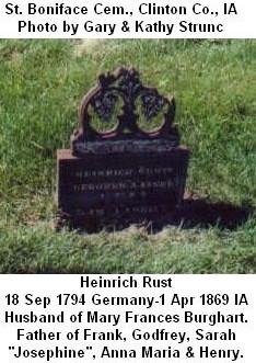
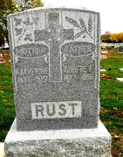
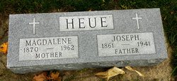
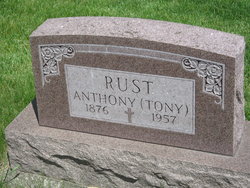
| Description | : | SON of Heinrich Rust and Mary Frances Burghart. BROTHER of Franz "Frank", Sarah Josephine (Larch/Lerch), Anna Maria (Simmons/Simons) and Heinrich Wilhelm "Henry." HUSBAND of Catharina Wucherpfenning & Katherine Helmer. FATHER OF: by Catharina Wucherpfenning; Godfrey, Paulina "Lina" (Sister M. Aegidia) and Joseph. by Katherine Helmer; Anna (Grote), Helen Magdalena (Heue), Anton "Tony" and Mary Catherine. Immigrated with 2nd wife Katharina (Helmer) and 6 children, listed as Gottfried, Lina, Josef, Anna, Magdalena & Anton. Arrived at Port of New York on May 19, 1880 on the German ship, Gellert, originating from Hamburg. |
frequently asked questions (FAQ):
-
Where is Godfrey Rust's memorial?
Godfrey Rust's memorial is located at: Clifton United Jewish Cemetery, Cincinnati, Hamilton County, USA.
-
When did Godfrey Rust death?
Godfrey Rust death on 11 Jan 1895 in Carroll, Carroll County, Iowa, USA
-
Where are the coordinates of the Godfrey Rust's memorial?
Latitude: 39.1470871
Longitude: -84.5292816
Family Members:
Parent
Spouse
Siblings

Children
Flowers:


Nearby Cemetories:
1. Hillside Chapel Crematory and Columbarium
Cincinnati, Hamilton County, USA
Coordinate: 39.1393509, -84.5247192
2. Vine Street Hill Cemetery
Cincinnati, Hamilton County, USA
Coordinate: 39.1516991, -84.5091019
3. Spring Grove Cemetery
Cincinnati, Hamilton County, USA
Coordinate: 39.1647900, -84.5231500
4. Wesleyan Cemetery
Cincinnati, Hamilton County, USA
Coordinate: 39.1599998, -84.5468979
5. Third Quaker Cemetery (Defunct)
Cincinnati, Hamilton County, USA
Coordinate: 39.1542400, -84.5523720
6. Saint John Cemetery
Saint Bernard, Hamilton County, USA
Coordinate: 39.1643982, -84.5053024
7. Methodist Protestant Cemetery (Defunct)
Cincinnati, Hamilton County, USA
Coordinate: 39.1324770, -84.4983160
8. Baltimore Pike Cemetery
Cincinnati, Hamilton County, USA
Coordinate: 39.1397018, -84.5681000
9. Second Quaker Cemetery (Defunct)
Cincinnati, Hamilton County, USA
Coordinate: 39.1153090, -84.5305240
10. First German Protestant Cemetery
Avondale, Hamilton County, USA
Coordinate: 39.1492004, -84.4863968
11. Martini United Church of Christ Cemetery
Fairmount, Hamilton County, USA
Coordinate: 39.1296272, -84.5664902
12. Christ Church Cemetery
Over-The-Rhine, Hamilton County, USA
Coordinate: 39.1126480, -84.5157623
13. Saint Mary Cemetery
Saint Bernard, Hamilton County, USA
Coordinate: 39.1664009, -84.4880981
14. Lincoln Park Potters Field (Defunct)
Cincinnati, Hamilton County, USA
Coordinate: 39.1097710, -84.5346450
15. Christ Episcopal Churchyard (Defunct)
Cincinnati, Hamilton County, USA
Coordinate: 39.1100520, -84.5177220
16. Potters Field
Cincinnati, Hamilton County, USA
Coordinate: 39.1094440, -84.5188890
17. Walnut Hills Cemetery
Cincinnati, Hamilton County, USA
Coordinate: 39.1355950, -84.4809040
18. Presbyterian Burying Ground
Cincinnati, Hamilton County, USA
Coordinate: 39.1082510, -84.5175720
19. Thomas Williams Cemetery (Defunct)
Cincinnati, Hamilton County, USA
Coordinate: 39.1085060, -84.5146050
20. Chestnut Street Cemetery
Over-The-Rhine, Hamilton County, USA
Coordinate: 39.1071610, -84.5212210
21. Catherine Street Burying Ground
Cincinnati, Hamilton County, USA
Coordinate: 39.1067490, -84.5252700
22. Enon Baptist Church Burying Ground (Defunct)
Cincinnati, Hamilton County, USA
Coordinate: 39.1065420, -84.5238110
23. Catherine Street Methodist Cemetery (Defunct)
Cincinnati, Hamilton County, USA
Coordinate: 39.1064840, -84.5243150
24. Walnut Hills Jewish Cemetery
Evanston, Hamilton County, USA
Coordinate: 39.1403700, -84.4731300