
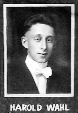
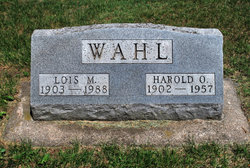
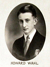
Harold Oliver Wahl
| Birth | : | 9 Apr 1902 Paton, Greene County, Iowa, USA |
| Death | : | 26 Jul 1957 Greene County, Iowa, USA |
| Burial | : | Rakaia Cemetery, Rakaia, Ashburton District, New Zealand |
| Coordinate | : | -43.7548910, 171.9939270 |
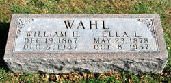
| Description | : | SERVICES FOR HAROLD WAHL HELD IN PATON Funeral services for Harold Oliver Wahl, 55, were held at 2 p.m., Monday in the Methodist church at Paton, with the Rev. Duane Manning, minister of the Methodist churches in Paton and Dana, officiating. Interment was in charge of Gem Lodge No. 429 A.F. & A.M. at the Paton Twp. cemetery. Harold Oliver Wahl, son of William H. and Ella Lang Wahl, was born in Paton on April 9, 1902. He passed away as a result of an auto accident on July 26, at the age of 55 years, 3 months and 17 days. Harold spent all... Read More |
frequently asked questions (FAQ):
-
Where is Harold Oliver Wahl's memorial?
Harold Oliver Wahl's memorial is located at: Rakaia Cemetery, Rakaia, Ashburton District, New Zealand.
-
When did Harold Oliver Wahl death?
Harold Oliver Wahl death on 26 Jul 1957 in Greene County, Iowa, USA
-
Where are the coordinates of the Harold Oliver Wahl's memorial?
Latitude: -43.7548910
Longitude: 171.9939270
Family Members:
Parent

Spouse
Siblings
Flowers:


Nearby Cemetories:
1. Chertsey Cemetery
Chertsey, Ashburton District, New Zealand
Coordinate: -43.8030500, 171.9319400
2. Barrhill Cemetery
Barrhill, Ashburton District, New Zealand
Coordinate: -43.6756950, 171.8480790
3. Dunsandel Cemetery
Dunsandel, Selwyn District, New Zealand
Coordinate: -43.6710940, 172.1382620
4. Dorie Cemetery
Dorie, Ashburton District, New Zealand
Coordinate: -43.8772900, 172.0862500
5. Killinchy Cemetery
Leeston, Selwyn District, New Zealand
Coordinate: -43.7325610, 172.2411540
6. Kyle Cemetery
Dorie, Ashburton District, New Zealand
Coordinate: -43.9193236, 172.0979192
7. Bishops Corner Cemetery
Southbridge, Selwyn District, New Zealand
Coordinate: -43.7824100, 172.2422900
8. St James Churchyard
Southbridge, Selwyn District, New Zealand
Coordinate: -43.8092360, 172.2502680
9. Ellesmere Public Cemetery
Leeston, Selwyn District, New Zealand
Coordinate: -43.7775690, 172.2599220
10. Ellesmere Catholic Cemetery
Leeston, Selwyn District, New Zealand
Coordinate: -43.7845860, 172.2690990
11. Ashburton Public Cemetery
Ashburton, Ashburton District, New Zealand
Coordinate: -43.8903240, 171.7702810
12. Brookside Cemetery
Brookside, Selwyn District, New Zealand
Coordinate: -43.6751800, 172.2683700
13. Greendale Cemetery
Greendale, Selwyn District, New Zealand
Coordinate: -43.5447560, 172.0772460
14. Highbank Cemetery
Highbank, Ashburton District, New Zealand
Coordinate: -43.6228060, 171.7387780
15. St Luke's Anglican Churchyard
Brookside, Selwyn District, New Zealand
Coordinate: -43.6903100, 172.3029000
16. Pioneer Park Memorial
Ashburton, Ashburton District, New Zealand
Coordinate: -43.9106400, 171.7485300
17. Hororata Cemetery
Hororata, Selwyn District, New Zealand
Coordinate: -43.5196600, 171.9461100
18. St Johns Churchyard
Hororata, Selwyn District, New Zealand
Coordinate: -43.5189100, 171.9457550
19. Sedgemere Cemetery
Sedgemere, Selwyn District, New Zealand
Coordinate: -43.8366600, 172.3149500
20. Glenroy War Memorial
Glenroy, Selwyn District, New Zealand
Coordinate: -43.5199750, 171.8345040
21. Methven Cemetery
Methven, Ashburton District, New Zealand
Coordinate: -43.6346810, 171.6563070
22. St Joseph's Catholic Cemetery
Darfield, Selwyn District, New Zealand
Coordinate: -43.4918030, 172.1081060
23. South Malvern Cemetery
Glentunnel, Selwyn District, New Zealand
Coordinate: -43.4807300, 171.9475200
24. Trinity Church Columbarium
Darfield, Selwyn District, New Zealand
Coordinate: -43.4888350, 172.1052750