

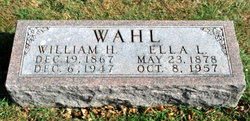
William Harold Wahl
| Birth | : | 19 Dec 1867 Muscatine County, Iowa, USA |
| Death | : | 6 Dec 1947 Paton, Greene County, Iowa, USA |
| Burial | : | Rakaia Cemetery, Rakaia, Ashburton District, New Zealand |
| Coordinate | : | -43.7548910, 171.9939270 |
frequently asked questions (FAQ):
-
Where is William Harold Wahl's memorial?
William Harold Wahl's memorial is located at: Rakaia Cemetery, Rakaia, Ashburton District, New Zealand.
-
When did William Harold Wahl death?
William Harold Wahl death on 6 Dec 1947 in Paton, Greene County, Iowa, USA
-
Where are the coordinates of the William Harold Wahl's memorial?
Latitude: -43.7548910
Longitude: 171.9939270
Family Members:
Parent

Spouse
Children
Flowers:


Nearby Cemetories:
1. Chertsey Cemetery
Chertsey, Ashburton District, New Zealand
Coordinate: -43.8030500, 171.9319400
2. Barrhill Cemetery
Barrhill, Ashburton District, New Zealand
Coordinate: -43.6756950, 171.8480790
3. Dunsandel Cemetery
Dunsandel, Selwyn District, New Zealand
Coordinate: -43.6710940, 172.1382620
4. Dorie Cemetery
Dorie, Ashburton District, New Zealand
Coordinate: -43.8772900, 172.0862500
5. Killinchy Cemetery
Leeston, Selwyn District, New Zealand
Coordinate: -43.7325610, 172.2411540
6. Kyle Cemetery
Dorie, Ashburton District, New Zealand
Coordinate: -43.9193236, 172.0979192
7. Bishops Corner Cemetery
Southbridge, Selwyn District, New Zealand
Coordinate: -43.7824100, 172.2422900
8. St James Churchyard
Southbridge, Selwyn District, New Zealand
Coordinate: -43.8092360, 172.2502680
9. Ellesmere Public Cemetery
Leeston, Selwyn District, New Zealand
Coordinate: -43.7775690, 172.2599220
10. Ellesmere Catholic Cemetery
Leeston, Selwyn District, New Zealand
Coordinate: -43.7845860, 172.2690990
11. Ashburton Public Cemetery
Ashburton, Ashburton District, New Zealand
Coordinate: -43.8903240, 171.7702810
12. Brookside Cemetery
Brookside, Selwyn District, New Zealand
Coordinate: -43.6751800, 172.2683700
13. Greendale Cemetery
Greendale, Selwyn District, New Zealand
Coordinate: -43.5447560, 172.0772460
14. Highbank Cemetery
Highbank, Ashburton District, New Zealand
Coordinate: -43.6228060, 171.7387780
15. St Luke's Anglican Churchyard
Brookside, Selwyn District, New Zealand
Coordinate: -43.6903100, 172.3029000
16. Pioneer Park Memorial
Ashburton, Ashburton District, New Zealand
Coordinate: -43.9106400, 171.7485300
17. Hororata Cemetery
Hororata, Selwyn District, New Zealand
Coordinate: -43.5196600, 171.9461100
18. St Johns Churchyard
Hororata, Selwyn District, New Zealand
Coordinate: -43.5189100, 171.9457550
19. Sedgemere Cemetery
Sedgemere, Selwyn District, New Zealand
Coordinate: -43.8366600, 172.3149500
20. Glenroy War Memorial
Glenroy, Selwyn District, New Zealand
Coordinate: -43.5199750, 171.8345040
21. Methven Cemetery
Methven, Ashburton District, New Zealand
Coordinate: -43.6346810, 171.6563070
22. St Joseph's Catholic Cemetery
Darfield, Selwyn District, New Zealand
Coordinate: -43.4918030, 172.1081060
23. South Malvern Cemetery
Glentunnel, Selwyn District, New Zealand
Coordinate: -43.4807300, 171.9475200
24. Trinity Church Columbarium
Darfield, Selwyn District, New Zealand
Coordinate: -43.4888350, 172.1052750