
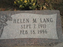
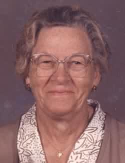
Helen May Lang
| Birth | : | 7 Sep 1911 Emerson, Mills County, Iowa, USA |
| Death | : | 18 Feb 1996 Nevada, Story County, Iowa, USA |
| Burial | : | All Saints Churchyard, Wrington, North Somerset Unitary Authority, England |
| Coordinate | : | 51.3610710, -2.7657110 |
| Plot | : | 3rd Addition, Lot |
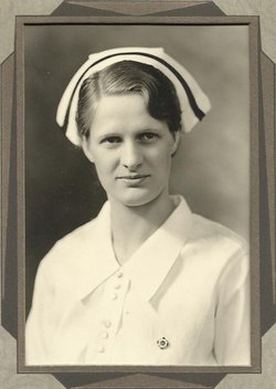
| Description | : | HELEN M. LANG Helen M. Lang, 84, of Nevada, Iowa, died Sunday, February 18, 1996 from cancer at Story County Long Term Care Facility in Nevada, Iowa. Helen was born on September 7, 1911 in Emerson, Iowa to Charles D. and Gertrude (Brown) Lang. She has been a resident in Nevada since 1951. She graduated from Emerson High School in 1930 and graduated from Iowa Methodist School of Nursing in 1934. Helen took post graduate courses at Barnes Hospital in St. Louis, Missouri and worked at the University Hospital in Ann Arbor, Michigan, then moved to Des Moines to work... Read More |
frequently asked questions (FAQ):
-
Where is Helen May Lang's memorial?
Helen May Lang's memorial is located at: All Saints Churchyard, Wrington, North Somerset Unitary Authority, England.
-
When did Helen May Lang death?
Helen May Lang death on 18 Feb 1996 in Nevada, Story County, Iowa, USA
-
Where are the coordinates of the Helen May Lang's memorial?
Latitude: 51.3610710
Longitude: -2.7657110
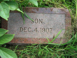
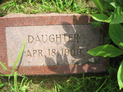
Family Members:
Parent
Siblings
Flowers:


Nearby Cemetories:
1. All Saints Churchyard
Wrington, North Somerset Unitary Authority, England
Coordinate: 51.3610710, -2.7657110
2. Wrington Chapel
Wrington, North Somerset Unitary Authority, England
Coordinate: 51.3651900, -2.7638270
3. Langford Chapelyard
Lower Langford, North Somerset Unitary Authority, England
Coordinate: 51.3434850, -2.7715630
4. St Mary's Church
Lower Langford, North Somerset Unitary Authority, England
Coordinate: 51.3399805, -2.7813469
5. Christ Church Churchyard
Redhill, North Somerset Unitary Authority, England
Coordinate: 51.3657790, -2.7245240
6. St Andrew Churchyard
Congresbury, North Somerset Unitary Authority, England
Coordinate: 51.3701100, -2.8121320
7. Holy Trinity Churchyard
Cleeve, North Somerset Unitary Authority, England
Coordinate: 51.3908200, -2.7773600
8. Holy Trinity Churchyard
Burrington, North Somerset Unitary Authority, England
Coordinate: 51.3307830, -2.7496010
9. Methodist Church Burial Ground
Churchill, North Somerset Unitary Authority, England
Coordinate: 51.3344140, -2.8000610
10. Saint John the Baptist Churchyard
Churchill, North Somerset Unitary Authority, England
Coordinate: 51.3384750, -2.8092710
11. St. Nicholas' Churchyard
Brockley, North Somerset Unitary Authority, England
Coordinate: 51.3988950, -2.7686830
12. Yatton Parish Council Burial Grounds
Yatton, North Somerset Unitary Authority, England
Coordinate: 51.3840541, -2.8182519
13. St Michael and All Angels
Rowberrow, North Somerset Unitary Authority, England
Coordinate: 51.3240000, -2.7915000
14. St. Mary's Churchyard
Yatton, North Somerset Unitary Authority, England
Coordinate: 51.3847720, -2.8185510
15. St. Michael and All Angels Churchyard
Butcombe, North Somerset Unitary Authority, England
Coordinate: 51.3538470, -2.6973670
16. Shipham Cemetery
Shipham, Sedgemoor District, England
Coordinate: 51.3201930, -2.7992390
17. St Andrew Churchyard
Blagdon, North Somerset Unitary Authority, England
Coordinate: 51.3275610, -2.7127710
18. St Katharine and The Noble Army Churchyard
Felton, North Somerset Unitary Authority, England
Coordinate: 51.3876440, -2.6979950
19. Saint Bridget's Churchyard
Chelvey, North Somerset Unitary Authority, England
Coordinate: 51.4117570, -2.7689680
20. St Leonard's Churchyard
Shipham, Sedgemoor District, England
Coordinate: 51.3130980, -2.8001830
21. Holy Saviour Churchyard
Puxton, North Somerset Unitary Authority, England
Coordinate: 51.3652680, -2.8536510
22. St. Andrew's Churchyard
Backwell, North Somerset Unitary Authority, England
Coordinate: 51.4118600, -2.7297400
23. Winscombe and Sandford Cemetery
Winscombe, North Somerset Unitary Authority, England
Coordinate: 51.3223861, -2.8386889
24. Blessed Virgin Mary Churchyard
Nempnett Thrubwell, Bath and North East Somerset Unitary Authority, England
Coordinate: 51.3407790, -2.6721100