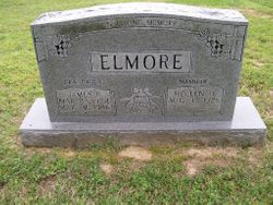
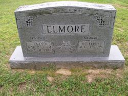
Hellen Oneida Cole Elmore
| Birth | : | 17 Aug 1928 Crockett County, Tennessee, USA |
| Death | : | 17 Nov 2014 Bells, Crockett County, Tennessee, USA |
| Burial | : | Lebanon United Methodist Church Cemetery, Friendship, Crockett County, USA |
| Coordinate | : | 35.8450880, -89.3062070 |
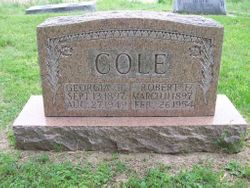
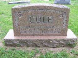
| Description | : | Wife of James R. Elmore who she married Sept. 26, 1950. ================== Hellen Oneida Elmore, age 86, of Halls died Monday, November 17, 2014 at Bells Nursing Home And Rehab of Bells, TN. Hellen was born August 17, 1928 in Crockett Co., TN. She is the daughter of the late Robert Edward and the late Georgia (Rowland) Cole. She married the late James Royce Elmore. She was a Homemaker. She is survived by one daughter: Kristi Elmore Sugg of Halls, TN and one son: Mike Elmore of Halls, TN; ; She also has three grandchildren. Grandson, James Ashley Elmore of Halls, TN; granddaughter, Anna... Read More |
frequently asked questions (FAQ):
-
Where is Hellen Oneida Cole Elmore's memorial?
Hellen Oneida Cole Elmore's memorial is located at: Lebanon United Methodist Church Cemetery, Friendship, Crockett County, USA.
-
When did Hellen Oneida Cole Elmore death?
Hellen Oneida Cole Elmore death on 17 Nov 2014 in Bells, Crockett County, Tennessee, USA
-
Where are the coordinates of the Hellen Oneida Cole Elmore's memorial?
Latitude: 35.8450880
Longitude: -89.3062070
Family Members:
Parent
Spouse
Children
Flowers:
Nearby Cemetories:
1. Lebanon United Methodist Church Cemetery
Friendship, Crockett County, USA
Coordinate: 35.8450880, -89.3062070
2. Glenn Cemetery
Crockett County, USA
Coordinate: 35.8509390, -89.3087660
3. Carter Cemetery
Chestnut Bluff, Crockett County, USA
Coordinate: 35.8500090, -89.3122250
4. Beasley-Albritton Cemetery
Chestnut Bluff, Crockett County, USA
Coordinate: 35.8584710, -89.3160610
5. Rowland Cemetery
Chestnut Bluff, Crockett County, USA
Coordinate: 35.8534820, -89.3267150
6. Siloam Cemetery
Dog Hill, Crockett County, USA
Coordinate: 35.8398940, -89.2832260
7. South Fork Cemetery
Chestnut Bluff, Crockett County, USA
Coordinate: 35.8646420, -89.3206200
8. Brooks Cemetery
Chestnut Bluff, Crockett County, USA
Coordinate: 35.8593500, -89.3319110
9. Parker - York Cemetery
Chestnut Bluff, Crockett County, USA
Coordinate: 35.8625990, -89.3290210
10. Riddick Cemetery #2
Crockett County, USA
Coordinate: 35.8347200, -89.2718080
11. Buck Cemetery
Frog Jump, Crockett County, USA
Coordinate: 35.8315620, -89.3441880
12. Dean Cemetery
Frog Jump, Crockett County, USA
Coordinate: 35.8162630, -89.2778440
13. Bucks Chapel Church Cemetery
Frog Jump, Crockett County, USA
Coordinate: 35.8126320, -89.2813750
14. Floyds Chapel Cemetery
Broadview, Crockett County, USA
Coordinate: 35.8403860, -89.2592840
15. Browder Family Cemetery
Broadview, Crockett County, USA
Coordinate: 35.8646890, -89.2623010
16. Antioch Cemetery
Friendship, Crockett County, USA
Coordinate: 35.8581090, -89.2577800
17. Scarborough Cemetery
Broadview, Crockett County, USA
Coordinate: 35.8432570, -89.2546330
18. Archers Chapel Methodist Cemetery
Frog Jump, Crockett County, USA
Coordinate: 35.8115250, -89.3406590
19. Riddick Cemetery #1
Maury City, Crockett County, USA
Coordinate: 35.8298200, -89.2429960
20. Stallcup Family Cemetery
Cross Roads, Dyer County, USA
Coordinate: 35.8980720, -89.3245320
21. Rucker Cemetery
Maury City, Crockett County, USA
Coordinate: 35.8054790, -89.2473390
22. Robertson-Warren Cemetery
Friendship, Crockett County, USA
Coordinate: 35.8830700, -89.2427200
23. Mount Moriah Cemetery
Friendship, Crockett County, USA
Coordinate: 35.8955420, -89.2576300
24. Cock and Irvin Cemetery
Hawkinsville, Dyer County, USA
Coordinate: 35.9104430, -89.3046210


