

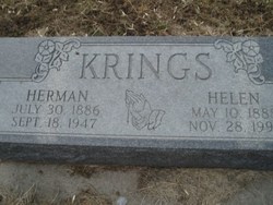
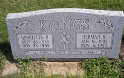
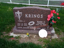
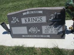
Herman Hilger Krings
| Birth | : | 16 Jan 1933 Tarnov, Platte County, Nebraska, USA |
| Death | : | 6 Nov 1983 Columbus, Platte County, Nebraska, USA |
| Burial | : | Our Lady and St Patrick's Church, Walton-le-Dale, South Ribble Borough, England |
| Coordinate | : | 53.7407250, -2.6408280 |
| Description | : | Son of Herman & Helen (Wagner) Krings. Married to Henrietta H. Shemek. |
frequently asked questions (FAQ):
-
Where is Herman Hilger Krings's memorial?
Herman Hilger Krings's memorial is located at: Our Lady and St Patrick's Church, Walton-le-Dale, South Ribble Borough, England.
-
When did Herman Hilger Krings death?
Herman Hilger Krings death on 6 Nov 1983 in Columbus, Platte County, Nebraska, USA
-
Where are the coordinates of the Herman Hilger Krings's memorial?
Latitude: 53.7407250
Longitude: -2.6408280
Family Members:
Parent
Spouse
Siblings
Children
Flowers:


Nearby Cemetories:
1. All Saints Churchyard
Walton-le-Dale, South Ribble Borough, England
Coordinate: 53.7407250, -2.6408280
2. Our Lady and St Patrick's Church
Walton-le-Dale, South Ribble Borough, England
Coordinate: 53.7407250, -2.6408280
3. St Leonard Churchyard
Walton-le-Dale, South Ribble Borough, England
Coordinate: 53.7476530, -2.6666950
4. St Mary's Churchyard Brownedge
Bamber Bridge, South Ribble Borough, England
Coordinate: 53.7305472, -2.6669416
5. St. Saviour's Churchyard
Bamber Bridge, South Ribble Borough, England
Coordinate: 53.7197301, -2.6598985
6. St. Leonard the Less Churchyard
Samlesbury, South Ribble Borough, England
Coordinate: 53.7680000, -2.6237000
7. St. Mary's and St. John RC Churchyard, Southworth
Samlesbury, South Ribble Borough, England
Coordinate: 53.7676690, -2.6183400
8. Preston Old Cemetery
Ribbleton, City of Preston, England
Coordinate: 53.7686352, -2.6623154
9. St. Josephs Roman Catholic Churchyard
Brindle, Chorley Borough, England
Coordinate: 53.7350780, -2.5880640
10. St. Bedes Churchyard
Clayton-le-Woods, Chorley Borough, England
Coordinate: 53.7079260, -2.6390320
11. Our Lady and Saint Gerards Churchyard
Lostock Hall, South Ribble Borough, England
Coordinate: 53.7279090, -2.6921460
12. St James's Churchyard
Brindle, Chorley Borough, England
Coordinate: 53.7133333, -2.6086111
13. Preston New Cemetery
Ribbleton, City of Preston, England
Coordinate: 53.7717400, -2.6620900
14. St Augustine of Canterbury
Preston, City of Preston, England
Coordinate: 53.7560420, -2.6912650
15. St. James' Churchyard
Preston, City of Preston, England
Coordinate: 53.7566010, -2.6941110
16. Holy Trinity Churchyard
Hoghton, Chorley Borough, England
Coordinate: 53.7279300, -2.5848550
17. St John Churchyard
Preston, City of Preston, England
Coordinate: 53.7582080, -2.6959750
18. St. Paul Churchyard
Preston, City of Preston, England
Coordinate: 53.7625360, -2.6947080
19. St. Ignatius RC Churchyard
Preston, City of Preston, England
Coordinate: 53.7635270, -2.6965870
20. St. George the Martyr
Preston, City of Preston, England
Coordinate: 53.7591220, -2.7025660
21. St. Wilfrid's Catholic Cemetery
Preston, City of Preston, England
Coordinate: 53.7581670, -2.7044930
22. St Paul Churchyard
Farington, South Ribble Borough, England
Coordinate: 53.7199900, -2.7017200
23. Friends Meeting House Burial Ground (Defunct)
Preston, City of Preston, England
Coordinate: 53.7610250, -2.7030380
24. Holy Trinity
Preston, City of Preston, England
Coordinate: 53.7613030, -2.7030580