

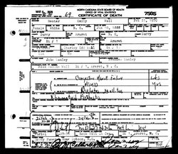
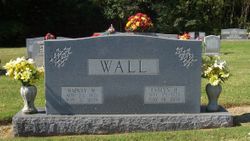
Hester Emily Danley Wall
| Birth | : | 10 Jan 1888 North Carolina, USA |
| Death | : | 25 Feb 1970 Ararat, Surry County, North Carolina, USA |
| Burial | : | Millers Chapel Cemetery, Dyersburg, Dyer County, USA |
| Coordinate | : | 35.9385986, -89.3163986 |
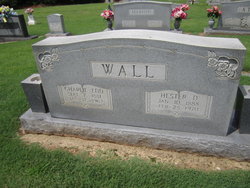
| Description | : | Wife of Charlie Edd Wall; daughter of John and Frances Danley. |
frequently asked questions (FAQ):
-
Where is Hester Emily Danley Wall's memorial?
Hester Emily Danley Wall's memorial is located at: Millers Chapel Cemetery, Dyersburg, Dyer County, USA.
-
When did Hester Emily Danley Wall death?
Hester Emily Danley Wall death on 25 Feb 1970 in Ararat, Surry County, North Carolina, USA
-
Where are the coordinates of the Hester Emily Danley Wall's memorial?
Latitude: 35.9385986
Longitude: -89.3163986
Family Members:
Parent
Spouse
Siblings
Children

Flowers:


Nearby Cemetories:
1. Millers Chapel Cemetery
Dyersburg, Dyer County, USA
Coordinate: 35.9385986, -89.3163986
2. Williams Chapel Cemetery
Bonicord, Dyer County, USA
Coordinate: 35.9472008, -89.3221970
3. Shelton Cemetery
Fowlkes, Dyer County, USA
Coordinate: 35.9416530, -89.3281750
4. Murray Cemetery
Bonicord, Dyer County, USA
Coordinate: 35.9485000, -89.2969000
5. Staggs Cemetery
Friendship, Dyer County, USA
Coordinate: 35.9397930, -89.2896620
6. Pate Family Cemetery
Bonicord, Dyer County, USA
Coordinate: 35.9575110, -89.3389720
7. Bell-Walker Cemetery
Tigrett, Dyer County, USA
Coordinate: 35.9581400, -89.2913360
8. Cock and Irvin Cemetery
Hawkinsville, Dyer County, USA
Coordinate: 35.9104430, -89.3046210
9. Nash Cemetery
Dyersburg, Dyer County, USA
Coordinate: 35.9252500, -89.2822230
10. Mount Pisgah Cemetery
Friendship, Dyer County, USA
Coordinate: 35.9162470, -89.2901740
11. Hardin Cemetery
Friendship, Dyer County, USA
Coordinate: 35.9243270, -89.2766430
12. Mose M. Thompson Cemetery
Friendship, Dyer County, USA
Coordinate: 35.9243680, -89.2765870
13. Zion Hill Church Cemetery
Friendship, Dyer County, USA
Coordinate: 35.9095110, -89.2900760
14. Palestine Cemetery
Bruceville, Dyer County, USA
Coordinate: 35.9183080, -89.3536090
15. Peal and Bailey Land Cemetery
Bruceville, Dyer County, USA
Coordinate: 35.9256960, -89.3584940
16. Jones Cemetery
Tigrett, Dyer County, USA
Coordinate: 35.9552230, -89.2747450
17. Stallcup Family Cemetery
Cross Roads, Dyer County, USA
Coordinate: 35.8980720, -89.3245320
18. Clay Cemetery
Fowlkes, Dyer County, USA
Coordinate: 35.9760780, -89.3453920
19. Sorrell Chapel Cemetery
Bonicord, Dyer County, USA
Coordinate: 35.9772470, -89.3458570
20. Holly Springs Cemetery
Fowlkes, Dyer County, USA
Coordinate: 35.9622940, -89.3685410
21. Hodge Cemetery
Dyersburg, Dyer County, USA
Coordinate: 35.9836620, -89.3532490
22. McCoy Cemetery
Dyer County, USA
Coordinate: 35.9536018, -89.3827972
23. Saint Peter Cemetery
Tigrett, Dyer County, USA
Coordinate: 35.9616440, -89.2520140
24. Bellevernon Cemetery
Friendship, Crockett County, USA
Coordinate: 35.9135830, -89.2495910