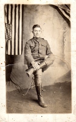
Hiram H. Odom
| Birth | : | 1896 |
| Death | : | 1 Nov 1979 Hamblen County, Tennessee, USA |
| Burial | : | Central United Methodist Church Cemetery, Bean Station, Grainger County, USA |
| Coordinate | : | 36.3422740, -83.2798470 |
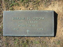
| Inscription | : | "PFC US Army World War I" |
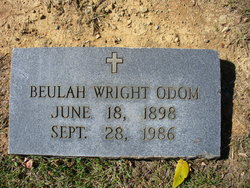
| Description | : | "ODOM, HIRAM HOWARD -- age 83, of Bean Station, died in Morristown-Hamblen Hospital, 5 a.m. Thursday. He was a WWI veteran and a retired farmer. Member of Barnard's Grove Baptist Church. Survivors: wife, Mrs. Beulah W. Odom, 4 daughters, Mrs. Frank (Imogene) Bly, Cupertino, Calif., Mrs. J. Walker (Mae) Hale, Birmingham, Ala., Mrs. Charles (June) Haynes, Oak Ridge, Mrs. John D. (Ruth) Brooks, Knoxville; sister, Mrs. Laura Wilder, Whitesburg; 10 grandchildren; 1 great-grandchild. Graveside services 10 a.m. Saturday, Central United Methodist Church Cemetery, Rev. Warren Stewart officiating. In lieu of flowers, memorials may be made to the Bean Station Rescue... Read More |
frequently asked questions (FAQ):
-
Where is Hiram H. Odom's memorial?
Hiram H. Odom's memorial is located at: Central United Methodist Church Cemetery, Bean Station, Grainger County, USA.
-
When did Hiram H. Odom death?
Hiram H. Odom death on 1 Nov 1979 in Hamblen County, Tennessee, USA
-
Where are the coordinates of the Hiram H. Odom's memorial?
Latitude: 36.3422740
Longitude: -83.2798470
Family Members:
Flowers:
Nearby Cemetories:
1. Central United Methodist Church Cemetery
Bean Station, Grainger County, USA
Coordinate: 36.3422740, -83.2798470
2. Moores Chapel Cemetery
Bean Station, Grainger County, USA
Coordinate: 36.3488998, -83.2897034
3. DeBord Cemetery
Bean Station, Grainger County, USA
Coordinate: 36.3315000, -83.2834000
4. Meadow Branch Cemetery
Bean Station, Grainger County, USA
Coordinate: 36.3572006, -83.2822037
5. Holt Cemetery #2
Bean Station, Grainger County, USA
Coordinate: 36.3630560, -83.2844440
6. County Line Cemetery
Bean Station, Grainger County, USA
Coordinate: 36.3207700, -83.2789850
7. Meek Cemetery
Bean Station, Grainger County, USA
Coordinate: 36.3207180, -83.2797150
8. Garrett Cemetery
Grainger County, USA
Coordinate: 36.3414001, -83.3082962
9. First Independent Freewill Baptist Church Cemetery
Bean Station, Grainger County, USA
Coordinate: 36.3158860, -83.2855850
10. Samsel Cemetery
Bean Station, Grainger County, USA
Coordinate: 36.3424020, -83.3167060
11. Adriel Baptist Church Cemetery
Bean Station, Grainger County, USA
Coordinate: 36.3125000, -83.2897034
12. Samsel Lakeview Cemetery
Bean Station, Grainger County, USA
Coordinate: 36.3475800, -83.3189468
13. Samsel Cemetery
Bean Station, Grainger County, USA
Coordinate: 36.3114014, -83.2925034
14. Dalton Cemetery
Bean Station, Grainger County, USA
Coordinate: 36.3428001, -83.3296967
15. Dodson Cemetery
Bean Station, Grainger County, USA
Coordinate: 36.2989006, -83.2869034
16. Rocky Summit Cemetery
Bean Station, Grainger County, USA
Coordinate: 36.2984750, -83.2799030
17. Grantham Cemetery
Grainger County, USA
Coordinate: 36.2946860, -83.2794570
18. Harris Cemetery
Grainger County, USA
Coordinate: 36.3055992, -83.3308029
19. Taylor Family Cemetery
Bean Station, Grainger County, USA
Coordinate: 36.2876670, -83.2907330
20. Ford Cemetery
Grainger County, USA
Coordinate: 36.2902985, -83.3071976
21. Noeton Baptist Church Cemetery Original
Bean Station, Grainger County, USA
Coordinate: 36.3012600, -83.3342200
22. Armstrong Cemetery
Hawkins County, USA
Coordinate: 36.3417015, -83.2031021
23. Livingston Cemetery
Bean Station, Grainger County, USA
Coordinate: 36.2785988, -83.2791977
24. Harrell Cemetery
Bean Station, Grainger County, USA
Coordinate: 36.3074989, -83.3463974


