
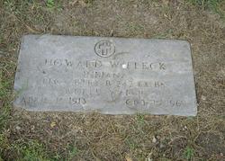
Howard Woodrow Fleck
| Birth | : | 15 Apr 1913 Kalamazoo, Kalamazoo County, Michigan, USA |
| Death | : | 15 Oct 1969 Kalamazoo, Kalamazoo County, Michigan, USA |
| Burial | : | Adriel Baptist Church Cemetery, Bean Station, Grainger County, USA |
| Coordinate | : | 36.3125000, -83.2897034 |
| Plot | : | Sec OP, lot 290, sp 4 |
| Description | : | Served as Private in US Army Battery B 242nd FA BN during World War II. |
frequently asked questions (FAQ):
-
Where is Howard Woodrow Fleck's memorial?
Howard Woodrow Fleck's memorial is located at: Adriel Baptist Church Cemetery, Bean Station, Grainger County, USA.
-
When did Howard Woodrow Fleck death?
Howard Woodrow Fleck death on 15 Oct 1969 in Kalamazoo, Kalamazoo County, Michigan, USA
-
Where are the coordinates of the Howard Woodrow Fleck's memorial?
Latitude: 36.3125000
Longitude: -83.2897034
Family Members:
Parent
Siblings


Nearby Cemetories:
1. Adriel Baptist Church Cemetery
Bean Station, Grainger County, USA
Coordinate: 36.3125000, -83.2897034
2. Samsel Cemetery
Bean Station, Grainger County, USA
Coordinate: 36.3114014, -83.2925034
3. First Independent Freewill Baptist Church Cemetery
Bean Station, Grainger County, USA
Coordinate: 36.3158860, -83.2855850
4. Meek Cemetery
Bean Station, Grainger County, USA
Coordinate: 36.3207180, -83.2797150
5. County Line Cemetery
Bean Station, Grainger County, USA
Coordinate: 36.3207700, -83.2789850
6. Dodson Cemetery
Bean Station, Grainger County, USA
Coordinate: 36.2989006, -83.2869034
7. Rocky Summit Cemetery
Bean Station, Grainger County, USA
Coordinate: 36.2984750, -83.2799030
8. Grantham Cemetery
Grainger County, USA
Coordinate: 36.2946860, -83.2794570
9. DeBord Cemetery
Bean Station, Grainger County, USA
Coordinate: 36.3315000, -83.2834000
10. Taylor Family Cemetery
Bean Station, Grainger County, USA
Coordinate: 36.2876670, -83.2907330
11. Ford Cemetery
Grainger County, USA
Coordinate: 36.2902985, -83.3071976
12. Central United Methodist Church Cemetery
Bean Station, Grainger County, USA
Coordinate: 36.3422740, -83.2798470
13. Garrett Cemetery
Grainger County, USA
Coordinate: 36.3414001, -83.3082962
14. Harris Cemetery
Grainger County, USA
Coordinate: 36.3055992, -83.3308029
15. Livingston Cemetery
Bean Station, Grainger County, USA
Coordinate: 36.2785988, -83.2791977
16. Moores Chapel Cemetery
Bean Station, Grainger County, USA
Coordinate: 36.3488998, -83.2897034
17. Samsel Cemetery
Bean Station, Grainger County, USA
Coordinate: 36.3424020, -83.3167060
18. Noeton Baptist Church Cemetery Original
Bean Station, Grainger County, USA
Coordinate: 36.3012600, -83.3342200
19. Samsel Lakeview Cemetery
Bean Station, Grainger County, USA
Coordinate: 36.3475800, -83.3189468
20. N L Henard Cemetery
Morristown, Hamblen County, USA
Coordinate: 36.2708221, -83.2726048
21. Dalton Cemetery
Bean Station, Grainger County, USA
Coordinate: 36.3428001, -83.3296967
22. Meadow Branch Cemetery
Bean Station, Grainger County, USA
Coordinate: 36.3572006, -83.2822037
23. Harrell Cemetery
Bean Station, Grainger County, USA
Coordinate: 36.3074989, -83.3463974
24. Holt Cemetery #2
Bean Station, Grainger County, USA
Coordinate: 36.3630560, -83.2844440